
Montsec Range facts for kids
Quick facts for kids Montsec |
|
|---|---|

Serrat de la Corona ridges of the Montsec d'Ares; central sector of the Montsec Range
|
|
| Highest point | |
| Elevation | 1,676 m (5,499 ft) |
| Geography | |

Montsec
Location in Pyrenees
|
|
| Location | Aragon & Catalonia |
| Parent range | Pre-Pyrenees |
| Geology | |
| Mountain type | Limestone |
The Montsec Range is a cool mountain system in the Pre-Pyrenees area of Spain. It's known for its unique rock formations and beautiful views. The name "Montsec" comes from the Latin words Montus sectus, which means "cut mountain." This name perfectly describes its steep cliffs and deep gorges.
Contents
What is the Montsec Range?
The Montsec Range is a group of mountain ranges made mostly of calcareous rock, which is a type of rock containing calcium carbonate. These mountains stretch for about 40 kilometers (25 miles) from east to west. The entire area covers about 187 square kilometers (72 square miles). You can find the Montsec Range in two parts of Spain: the Catalan province of Lleida and the Aragonese province of Huesca.
Exploring Montsec's Geography
The Montsec Range acts as the southern edge of the Pallars region. It's split into three main parts by three important rivers in Catalonia. These rivers have carved out amazing features over time.
- Montsec de Rúbies: This is the eastern part of the range. It's separated by the Segre River to the east and the Noguera Pallaresa River in the middle.
- Montsec d'Ares: This is the central part of the range. It's located between the Noguera Pallaresa and Noguera Ribagorçana rivers.
- Montsec d'Estall: This part is in Aragon, to the west. The Noguera Ribagorçana River separates it from the central Montsec d'Ares.
Two famous gorges, called congostos, have been formed by these rivers and by the movement of the Earth's crust. These are the Terradets gorge and the Montrebei gorge. The highest point in the Montsec Range is a peak called Santalís, which is 1,678 meters (5,505 feet) tall. From Santalís, you can see amazing views of Àger and the plains of Lleida to the south, and the tall Pyrenees mountains to the north.
The southern side of Montsec looks like a giant wall, while the northern side, though not as steep, still rises about 1,000 meters (3,280 feet) above the Tremp basin below.
How was Montsec Formed?
The Montsec Range has a long and interesting history of how it was made. It all started when thick layers of sediment, thousands of meters deep, settled at the bottom of a sea during the Cretaceous period. This was a very long time ago, when dinosaurs roamed the Earth!
Later, these layers were pushed up and partly covered by another sea during the Eocene period. Finally, the powerful forces that created the Pyrenees mountains pushed them up even higher. This process, called folding, shaped the Montsec into the mountains we see today. Because of this history, it's quite easy to find fossils from the Mesozoic era in the Montsec area. The fossil deposits near Vilanova de Meià are some of the most important in the world!
Montsec's Past: A Strategic Location
The Montsec Range has always been a great natural fortress. Its high position over the plains and protection from cold northern winds made it very important for defense. This was especially true during the Reconquista, a time when Christian kingdoms were trying to take back land from the Arab rulers in Spain.
In the 10th century, when the caliphate of Córdoba was very powerful, the city of Balaguer was the northernmost Arab city. Castles like Castelló de Farfanya, Algerri, and Os de Balaguer, along with many watchtowers, formed a strong line of defense against the Christian armies to the north of Montsec.
In the 11th and 18th centuries, this area was one of the most populated parts of Catalonia. However, the number of people living here started to drop in the early 1900s. Today, many people have moved away, and some villages are almost empty.
What is the Economy Like in Montsec?
Farming in the Montsec area is quite difficult because it's hard to get enough water for irrigation. Local farmers mostly grow barley and almonds. Hydroelectric power, which uses water to create electricity, is another important resource. However, many people believe that developing tourism will be the best way to help the region grow and bring more opportunities.
Images for kids
-
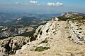
Sant Alís is a 1,675 meter high peak in the Serra del Montsec.
-
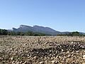
Cliffs at the Montsec de Rúbies seen from Montadó.
-
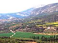
A view of Corçà, in the Àger municipality, with the Montsec d'Estall in the background.


.jpg)
See also
 In Spanish: Sierra del Montsec para niños
- Geology of the Pyrenees
- Pallars
