
Pre-Pyrenees facts for kids
Quick facts for kids Pre-Pyrenees |
|
|---|---|

Montsec d'Ares, part of the Pyrenees Foothills
|
|
| Dimensions | |
| Length | 425 km (264 mi) E/W |
| Width | 40 km (25 mi) N/S |
| Geography | |

Topographic map of the Pyrenees
|
|
| Countries | Spain and France |
| Range coordinates | 42°20′N 1°0′E / 42.333°N 1.000°E |
| Geology | |
| Orogeny | Alpine orogeny |

- Pyrenees
- Pre-Pyrenees
- Catalan Central Depression
- Smaller mountain ranges of the Central Depression
- Catalan Transversal Range
- Catalan Pre-Coastal Range
- Catalan Coastal Range
- Catalan Coastal Depression and other coastal and pre-coastal plains
The Pre-Pyrenees are like the smaller, lower mountains that sit right in front of the much bigger Pyrenees mountain range. Think of them as the "foothills" or the start of the Pyrenees.
Contents
What are the Pre-Pyrenees?
The Pre-Pyrenees are a mountain system that is actually part of the larger Pyrenees. They stretch out in a line from west to east, running right next to the main mountain range.
On the French side, the Pyrenees mountains drop down quite steeply. Because of this, the Pre-Pyrenees on the northern side are mostly found in an area called the Corbières Massif. This is towards the eastern end of the mountain system. There's also the Massif de Plantaurel further west, which is also a foothill, but not as clearly defined.
However, on the Spanish side, things look very different! Here, you'll find a huge and complicated system of foothill ranges. These stretch all the way from Navarre, across northern Aragon, and reach the Mediterranean coast in Catalonia. At the eastern end on the southern side, there's a special area known as the Sub-Pyrenees.
Important Mountain Ranges
Even though the highest peaks in the Pre-Pyrenees aren't as tall as those in the main Pyrenees, some of these ranges are still very big. Some mountain tops here can reach up to 2,600 meters (about 8,500 feet) high!
Northern slope
- Corbières Massif
- Massif de Plantaurel
Southern slope
The main ranges on the southern side are:
- In Catalonia
- Serra d'Aubenç
- Serra dels Bastets
- Serra de Bellmunt
- Cingles de Beví
- Serra de Boumort
- Serra de Busa
- Serra del Cadí
- Montsec de Tost
- Serra de Boumort
- Serra de Camporan
- Serra de les Canals
- Serra de Capsacosta
- Serra de Malforat
- Serra de la Cau
- Serra de Malforat
- Serra de Carreu
- El Catllaràs
- Serra de Comiols
- Serra del Port del Comte
- Serra de Querol
- Serra del Verd
- Serra de Conivella
- Serrat de la Creueta
- Serra d'Ensija
- La Faiada de Malpàs
- Serra de Falgars
- Serra de la Gessa
- Serra de Sant Mamet
- Serra de Moixeró
- Serra de Milany
- Mare de Déu del Mont
- Serra de Monebui
- Serra de Montclús
- Montsec range
- Montsec de Rúbies, the eastern massif, is separated by the river Segre in the east and the Noguera Pallaresa in the middle.
- Serra del Cucuc
- Montsec d'Ares, the central massif.
- Montrebei
- Montsec d'Estall, in Aragon, located to the west, separated by the Noguera Ribagorçana from the central massif.
- Montsec de Rúbies, the eastern massif, is separated by the river Segre in the east and the Noguera Pallaresa in the middle.
- Serra de Montgrony
- Serra de Prada
- Serra de Picamill
- Serra de Picancel
- Serra de Queralt
- Serra de Sant Gervàs
- Serra de Setcomelles
- Serra de Sant Joan
- Serra de Sant Marc
- Serra de serra de Sobremunt
- Serra del Volterol
- Serra dels Tossals
- Serra de Turp
- Rasos de Peguera
- Serrat de la Figuerassa
- In Aragon
- Sierra Caballera
- Sierra del Castillo de Llaguarres
- Sierra de la Carrodilla
- Cotiella
- Serra d'Esdolomada
- Sierra Ferrera
- Sierra de Giró
- Serra del Jordal
- Sierra de las Ares
- Sierra de Guara
- El Turbón
- Sierra de Sis
- Sierra de Santo Domingo
- Sierra de Loarre
- Sierra de Javierre
- Sierra Caballera
- In Navarre
- Sierra de Leire
Amazing Views and Landscapes
-
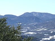
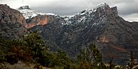
Serra del Cucuc and Montsec de Rúbies at Gavet de la Conca
-
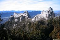
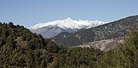
Summits of the Corbières Massif, the only foothill of the Pyrenees on their northern side
-
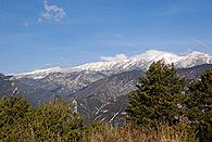
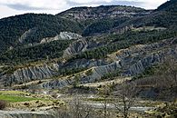
View of Serra del Cadí
-
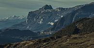
View of Serra Ferrera
-
View of the Mountains of Sis
-
Cotiella
-
View of Serra del Jordal


.jpg)


See also
 In Spanish: Prepirineo para niños
- Geology of the Pyrenees
- Sub-Pyrenees
- List of mountains in Catalonia
- List of mountains in Aragon
