
Moroni, Comoros facts for kids
Quick facts for kids
Moroni
موروني
Mūrūnī |
|
|---|---|
 .jpg)   (from top: left to right) Moroni in early July 2008, Mosque in Moroni, Moroni Catholic Church and Itsandra beach.
|
|

Moroni, Comoros
Location in Comoros
|
|
| Country | Comoros |
| Island | Grande Comore |
| Area | |
| • Total | 30 km2 (10 sq mi) |
| Elevation | 29 m (95 ft) |
| Population
(2016)
|
|
| • Total | 111,326 |
| • Density | 3,700/km2 (9,600/sq mi) |
| Time zone | UTC+03:00 (East Africa Time) |
| • Summer (DST) | (Not Observed) |
| Area code(s) | 269 |
Moroni is the largest city and the capital of the Union of the Comoros. This country is a group of islands in the Indian Ocean. The name Moroni means "at the river" in the local language, Shingazidja.
Moroni is also the capital of Ngazidja, which is the biggest of the three main islands in the country. In 2003, about 41,557 people lived in Moroni. The city has a port and many mosques, like the famous Badjanani Mosque.
Contents
History of Moroni

The early history of Moroni is not fully known. People started settling in the Comoros Islands around the 7th century. These early settlers were likely Arab sailors and farmers who spoke Bantu languages. Old pottery found from the 7th to 10th centuries shows that the islands were part of the growing Swahili civilization.
By the middle of the 1400s, Moroni was a busy town. It traded with other places across the Indian Ocean. The Badjanani Mosque, built in 1427, shows how rich the city was back then. Moroni and a nearby port called Ikoni were important centers of power for the Bambao kingdom.
Moroni became even more important in 1886. At that time, the Sultan of Bambao, Said Ali ibn Said Omar, made a deal with France. This made Moroni the main city for the French colonial government.
The city grew slowly during the 1900s. In 1958, only 6,545 people lived there. But that same year, it was decided to move the capital of the Comoros islands from Dzaoudzi to Moroni. After this, Moroni grew to become the biggest city in the country.
In 1999, there were some political changes in Moroni. A new leader, Colonel Azali Assoumani, took charge. Later, in 2003, an important agreement called the Moroni Agreement was signed. This helped the different islands of the Comoros work together. In 2010, the U.S. Navy's Seabees helped build the Hamramba School in Moroni. This was a helpful project done with the local military and government.
Geography of Moroni
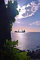
Moroni is located on the western coast of the island of Ngazidja. The city has a rocky coastline made of volcanic rock, so there are not many sandy beaches.
Famous Places in Moroni


The old part of Moroni is called the Medina. It has many narrow streets and old buildings. The most famous mosque is the Badjanani Mosque, also known as the Ancienne Mosquée de Vendredi (old Friday mosque). It was first built in 1427.
Moroni also has places for performances and events. The Alliance Franco-Comorienne has a theatre that can hold 300 people. There are also other venues like the Al-Kamar and the Palais du Peuple.
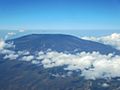
The nearby Mount Karthala volcano is a popular spot for hiking when it is not active.
Climate of Moroni
Moroni has a tropical rainforest climate. This means it gets a lot of rain throughout the year. The average yearly rainfall is about 2,700 millimeters (106 inches). The monsoon season, which brings heavy rains, lasts from November to April.
The temperature in Moroni stays pretty warm all year. High temperatures are usually between 32 to 34 degrees Celsius (90-93°F). Low temperatures are between 14 to 20 degrees Celsius (57-68°F). The area often has cyclones because it is in the western part of the Indian Ocean.
| Climate data for Moroni, Comoros | |||||||||||||
|---|---|---|---|---|---|---|---|---|---|---|---|---|---|
| Month | Jan | Feb | Mar | Apr | May | Jun | Jul | Aug | Sep | Oct | Nov | Dec | Year |
| Record high °C (°F) | 34 (93) |
34 (93) |
35 (95) |
34 (93) |
33 (91) |
32 (90) |
31 (88) |
31 (88) |
31 (88) |
33 (91) |
34 (93) |
36 (97) |
36 (97) |
| Mean daily maximum °C (°F) | 30.4 (86.7) |
30.4 (86.7) |
30.8 (87.4) |
30.4 (86.7) |
29.5 (85.1) |
28.4 (83.1) |
27.7 (81.9) |
27.7 (81.9) |
28.1 (82.6) |
29.1 (84.4) |
30.3 (86.5) |
30.8 (87.4) |
29.5 (85.1) |
| Mean daily minimum °C (°F) | 23.4 (74.1) |
23.3 (73.9) |
23.0 (73.4) |
22.6 (72.7) |
21.2 (70.2) |
19.6 (67.3) |
18.8 (65.8) |
18.4 (65.1) |
19.0 (66.2) |
20.3 (68.5) |
21.6 (70.9) |
22.6 (72.7) |
21.2 (70.2) |
| Record low °C (°F) | 20 (68) |
20 (68) |
20 (68) |
20 (68) |
17 (63) |
14 (57) |
14 (57) |
14 (57) |
15 (59) |
16 (61) |
18 (64) |
19 (66) |
14 (57) |
| Average rainfall mm (inches) | 364 (14.3) |
293 (11.5) |
279 (11.0) |
316 (12.4) |
256 (10.1) |
266 (10.5) |
244 (9.6) |
150 (5.9) |
108 (4.3) |
97 (3.8) |
108 (4.3) |
219 (8.6) |
2,700 (106.3) |
| Average rainy days | 18 | 16 | 18 | 18 | 12 | 12 | 12 | 10 | 11 | 12 | 12 | 16 | 167 |
| Average relative humidity (%) | 79 | 77 | 76 | 74 | 69 | 66 | 65 | 65 | 70 | 73 | 69 | 72 | 71 |
| Mean monthly sunshine hours | 187 | 177 | 225 | 192 | 232 | 231 | 236 | 232 | 221 | 237 | 230 | 212 | 2,612 |
| Source 1: World Meteorological Organization | |||||||||||||
| Source 2: BBC weather, Danish Meteorological Institute (sun and relative humidity, 1931–1960) | |||||||||||||
Mount Karthala
.jpg)
Moroni is located at the base of Mount Karthala. This active volcano is about 10 kilometers (6 miles) northwest of the city. It is one of the largest active volcanoes in the world. Mount Karthala erupts about every eleven years. In 2005, an eruption caused many people to move because of the volcanic ash.
Wildlife Around Moroni
The volcano near Moroni is home to many different bird species. Some of these include the Comoro pigeon, Karthala scops owl, and Comoro cuckoo-roller. You can also find birds like the Comoro drongo, Comoro thrush, and Comoro bulbul here.
People of Moroni
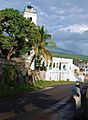
As of 2011, Moroni had about 54,000 people. Most people (98%) are Sunni Muslims. There is also a small group of Roman Catholics. The official languages of the Comoros are Shikomori, which is like Swahili, along with Arabic and French.
Places of Worship
Most places of worship in Moroni are Muslim mosques. There are also Christian churches and temples. These include churches for the Catholic Church, Protestant churches, and Evangelical Churches.
Economy of Moroni
Moroni produces several goods. These include vanilla, soft drinks, and essential oils. They also make metal and wood products, and a type of cement called pozzolana. These goods are sent out from the port.
Moroni has several banks, such as Banque Centrale des Comores. There are also a few markets, including the old market and the larger Volo Volo market.
Transport in Moroni


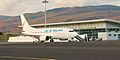
Moroni is served by the Prince Said Ibrahim International Airport. This airport is about 15 kilometers (9 miles) north of the city in Hahaya. It is a civilian airport with a paved runway. Airlines like Ethiopian Airlines, Air Tanzania, Air Austral, and Kenya Airways fly here. For travel between the islands, local airlines like Int'Air Iles and AB Aviation are used.
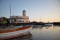
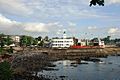
Moroni also has a main harbor, though it is small. It has regular boat services to the African mainland and other islands in the Comoros archipelago. Boats also travel to Madagascar and other Indian Ocean islands. The port has a small dock that is 80 meters (262 feet) long. It is not deep enough for very large ships because of coral reefs. The harbor has storage places like warehouses for goods coming in and going out, and for storing petroleum.
Images for kids
-
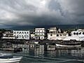
Moroni Harbour
-
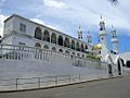
Mosque in Moroni
-
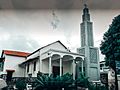
Catholic Church in Moroni
-
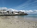
Itsandra beach
-
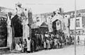
Moroni in 1908
-
Badjanani Mosque
-
Friday Mosque view from the old port
-
Mount Karthala
-
Prince Said Ibrahim International Airport
-
Moroni Harbour
-
Moroni Port in the foreground

See also
 In Spanish: Moroni (Comoras) para niños
