
Mount Boswell facts for kids
Quick facts for kids Mount Boswell |
|
|---|---|

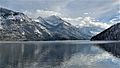
Mount Boswell above Waterton Lake
|
|
| Highest point | |
| Elevation | 2,454 m (8,051 ft) |
| Prominence | 194 m (636 ft) |
| Parent peak | Miche Wabun Peak (2701 m) |
| Listing | Mountains of Alberta |
| Geography | |

Mount Boswell
Location in Alberta

Mount Boswell
Location in Canada
|
|
| Location | Alberta, Canada |
| Parent range | Canadian Rockies |
| Topo map | NTS 82H04 |
| Geology | |
| Age of rock | Cambrian |
Mount Boswell is a tall mountain in Waterton Lakes National Park. It stands about 2,454 meters (8,051 feet) high. This peak is part of the Canadian Rockies in Alberta, Canada.
Mount Boswell sits on the east side of Waterton Lake. It is also very close to the border between Canada and the United States. The closest mountain that is taller than Mount Boswell is Miche Wabun Peak. It's about 5 kilometers (3.1 miles) away.
Mountain History
Mount Boswell got its name in 1917. It was named after Dr. W.G. Boswell. He was a veterinarian (an animal doctor) who worked for the group that marked the border between Canada and the United States.
The mountain's name became official in 1943. This was decided by the Geographical Names Board of Canada.
How Mountains Formed
Mount Boswell, like other mountains in Waterton Lakes National Park, is made of sedimentary rock. This type of rock forms from layers of sand, mud, and tiny bits of plants and animals that build up over millions of years. These layers were laid down from the Precambrian to Jurassic periods.
Long ago, this area was covered by shallow seas. The rock layers formed at the bottom of these seas. Later, during a time called the Laramide orogeny, huge forces pushed these rock layers. They were pushed up and over younger rocks, creating the mountains we see today.

Mountain Weather
Mount Boswell has a subarctic climate. This means it has very cold and snowy winters. The summers are usually mild.
Winter temperatures can drop below −20 degrees Celsius (−4 degrees Fahrenheit). With wind, it can feel even colder, sometimes below −30 degrees Celsius (−22 degrees Fahrenheit). All the rain and melting snow from Mount Boswell flows into Waterton Lake. From there, the water goes into the Waterton River.
Images for kids
-
Winter scene
-
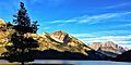
Mount Boswell centered, (Mt. Cleveland to right)
-
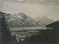
circa 1919


.jpg)
