
Mount Chardonnay facts for kids
Quick facts for kids Mount Chardonnay |
|
|---|---|

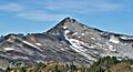
Mount Chardonnay, southeast aspect
|
|
| Highest point | |
| Elevation | 7,020 ft (2,140 m) |
| Prominence | 1,740 ft (530 m) |
| Geography | |

Mount Chardonnay
Location in Washington (state)

Mount Chardonnay
Location in the United States
|
|
| Location |
|
| Parent range | North Cascades Cascade Range |
| Topo map | USGS Mount Sefrit |
| Climbing | |
| Easiest route | Scramble |
Mount Chardonnay is a tall mountain peak in Washington state. It stands about 7,020 feet (2,140 meters) high. This mountain is part of the Skagit Range, which is a smaller group of mountains within the larger North Cascades. You can find Mount Chardonnay in Whatcom County.
The mountain is located inside the Mount Baker Wilderness. This special area is managed by the Mount Baker-Snoqualmie National Forest. Mount Chardonnay is not far from other peaks like Granite Mountain and Goat Mountain. Its closest higher neighbor is Mount Sefrit, which is about 2.77 miles (4.46 km) away. Rain and melting snow from Mount Chardonnay flow into Silesia Creek, which then joins the Fraser River.
Weather Around Mount Chardonnay
Mount Chardonnay is in a place with a "marine west coast" climate. This means it gets a lot of weather from the Pacific Ocean.

Most of the weather systems start over the Pacific Ocean. They travel northeast towards the Cascade Mountains. When these weather systems hit the tall peaks of the North Cascades, they are forced to rise. As they go higher, they drop their moisture as rain or snow. This is why the western side of the North Cascades gets a lot of rain and snow, especially in winter.
Because of the mild ocean influence, the area rarely gets extremely cold or hot. Temperatures are usually not below 0°F (-18°C) or above 80°F (27°C). Winters are often cloudy. However, during the summer, high-pressure systems over the Pacific Ocean bring clear skies. The snow here tends to be wet and heavy, which can increase the risk of avalanches. The best time to visit or climb Mount Chardonnay is usually from July to September, when the weather is most pleasant.
How Mount Chardonnay Was Formed

The North Cascades mountains, where Mount Chardonnay is located, have very rugged and dramatic landscapes. You can see sharp peaks, long ridges, and deep valleys carved by glaciers. The amazing shapes of these mountains and the big changes in elevation were created by geological events over millions of years. These events also led to the different climates you find across the Cascade Range.
The Cascade Mountains began forming millions of years ago. This happened when the North American Plate slowly moved over the Pacific Plate. This movement caused many volcanic eruptions over time. Also, small pieces of the Earth's crust, called terranes, came together to form the North Cascades about 50 million years ago.
Over the last two million years, during the Pleistocene period, huge sheets of ice called glaciers moved across the land. These glaciers repeatedly advanced and then melted back. As they moved, they scraped and shaped the landscape, leaving behind piles of rock. The river valleys in the area have a U-shape, which is a clear sign that glaciers were once there. The combination of the land being pushed up (uplift) and cracks in the Earth's crust (faulting), along with the action of glaciers, created the tall peaks and deep valleys we see in the North Cascades today.
Images for kids
-
Mount Chardonnay, southeast aspect
-
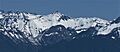
Chardonnay above Mamie Peak
-
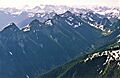
Skagit Range seen from Mount Larrabee. Mt. Chardonnay slightly right of center
