
Mount Larrabee facts for kids
Quick facts for kids Mount Larrabee |
|
|---|---|

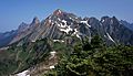
Mount Larrabee and the Border Peaks seen from Winchester Mountain Lookout
|
|
| Highest point | |
| Elevation | 7,865 ft (2,397 m) NAVD 88 |
| Prominence | 981 ft (299 m) |
| Isolation | 1.34 mi (2.16 km) |
| Parent peak | American Border Peak (7,994 ft} |
| Geography | |

Mount Larrabee
Location in Washington (state)

Mount Larrabee
Location in the United States
|
|
| Location |
|
| Parent range | Cascade Range North Cascades Skagit Range |
| Topo map | USGS Mount Larrabee |
| Climbing | |
| First ascent | September 11, 1908 by James J. McArthur and party |
| Easiest route | class 3 scramble |
Mount Larrabee is a mountain peak in the Skagit Range of the North Cascades. It stands 7,865 feet (2,397 meters) tall. You can find it in Washington state, about 1.4 miles south of the border with Canada.
This mountain is located right next to American Border Peak. It's part of the Mount Baker Wilderness, which is inside the Mount Baker-Snoqualmie National Forest. It's also quite close to North Cascades National Park.
Mount Larrabee is special because of its reddish color. This color comes from Iron in the rocks that has rusted, a process called oxidation. The rocks themselves are made of reddish layers of phyllite and greenstone.
The mountain was first called Red Mountain. But in 1951, its name was changed to honor Charles F. Larrabee (1895–1950). He was from the well-known Larrabee family in Bellingham, Washington. The new name was officially approved in 1951 by the United States Board on Geographic Names.
Contents
Seeing Mount Larrabee
You can see Mount Larrabee from the Mt. Baker Highway. Good viewing spots include Heather Meadows and Artist Point. People in the Fraser Valley in Canada can also see it.
On the east side of Mount Larrabee, there are sharp, jagged rock towers called The Pleiades. The mountain's northwest side connects to American Border Peak.
Water from the west side of Mount Larrabee flows into Tomyhoi Lake and Tomyhoi Creek. Water from the east side drains into Silesia Creek. There's also an unnamed glacier on the steep north face, sometimes called Larrabee Glacier.
Below this glacier is the Boundary Red Mountain Mine. Gold was found here in the early 1900s. Another mine, the Gargett Mine, was on the southwest slope.
Amazing Views from the Top
From the summit of Mount Larrabee, you get incredible wide-open views. You can see Tomyhoi Peak, American Border Peak, and Slesse Mountain. Other peaks visible include Mount Challenger, the Picket Range, Mount Shuksan, and Mount Baker.
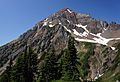
To reach the top, people usually use the Twin Lakes Road and High Pass Trail. The Winchester Mountain Lookout offers a great spot to take photos of Mount Larrabee. It also provides a place to stay overnight.
Weather and Climate

Mount Larrabee is in a marine west coast climate zone. This means it's near the ocean and has mild, wet weather. Most of the weather systems start over the Pacific Ocean. They then travel northeast towards the Cascade Mountains.
As these weather systems hit the North Cascades, the mountains force the air upward. This causes the air to cool and drop its moisture. So, the west side of the North Cascades gets a lot of rain or snowfall, especially in winter.
Because of the ocean's influence, the snow here is often wet and heavy. This can lead to a high risk of avalanches. The temperatures rarely go below 0°F (-18°C) or above 80°F (27°C).
In winter, it's usually cloudy. But in summer, high pressure systems over the Pacific Ocean often bring clear skies. The best months to visit or climb Mount Larrabee are July, August, and September.
How the Mountains Formed

The North Cascades have some of the roughest land in the Cascade Range. You'll find jagged peaks, sharp ridges, and deep valleys carved by glaciers. The way the land looks today is due to huge geological events that happened millions of years ago. These events created big changes in height and led to different climates and types of plants.
The Cascade Mountains started forming millions of years ago, during the late Eocene Epoch. The North American Plate was slowly moving over the Pacific Plate. This movement caused many volcanic eruptions. Also, small pieces of the Earth's crust, called terranes, came together to form the North Cascades about 50 million years ago.
During the Pleistocene period, which was over two million years ago, glaciers repeatedly moved across the land. They scraped away rock and left behind debris. The "U"-shaped valleys you see in the rivers were formed by these glaciers. The mountains' tall peaks and deep valleys were mainly created by the land being pushed up (called uplift) and broken along cracks (called faulting), combined with the action of glaciers.
Images for kids
-
from Winchester Mountain
-
from High Pass
-
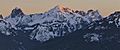
Winter sunrise


