
Ruth Mountain facts for kids
Quick facts for kids Ruth Mountain |
|
|---|---|

Ruth Mountain seen from Hannegan Peak
|
|
| Highest point | |
| Elevation | 7,115 ft (2,169 m) |
| Prominence | 1,315 ft (401 m) |
| Isolation | 2.85 mi (4.59 km) |
| Parent peak | Seahpo Peak (7,441 ft) |
| Geography | |

Ruth Mountain
Location in Washington (state)

Ruth Mountain
Location in the United States
|
|
| Location |
|
| Parent range | North Cascades |
| Topo map | USGS Mount Shuksan |
| Climbing | |
| First ascent | 1916 |
| Easiest route | Scramble, glacier travel |
Ruth Mountain is a tall mountain peak in Washington state. It stands about 7,115 ft (2,170 m) high in the Skagit Range. You can find it in the North Cascades, about two miles south of Hannegan Pass.
This mountain was named after Ruth Cleveland. She was the daughter of Grover Cleveland, who was a president of the United States. The name was officially chosen in 1952 by the United States Board on Geographic Names. This group helps decide names for places in the U.S.
Ruth Mountain sits right on the edge of two important areas. One is the North Cascades National Park. The other is the Mount Baker Wilderness. This wilderness area is part of the larger Mount Baker-Snoqualmie National Forest.
From the top of Ruth Mountain, you can see many other amazing peaks. These include Mount Shuksan, Seahpo Peak, and the jagged Picket Range. There's also the East Nooksack Glacier nearby.
A glacier on the north side of Ruth Mountain is called the Ruth Glacier. As it melts, its water forms the beginning of the Chilliwack River. Water from the mountain also flows into the Nooksack and Baker Rivers.
Mountain Weather and Climate
Ruth Mountain is in a place with a "marine west coast" climate. This means it gets a lot of moisture from the Pacific Ocean. Most of the weather systems come from the Pacific and move towards the Cascade Mountains.

When these weather systems hit the tall Cascade Mountains, they are forced to rise. This causes them to drop their moisture as rain or snowfall. Because of this, the western side of the North Cascades gets a lot of rain and snow. This is especially true in winter.
In winter, the weather is often cloudy. But in summer, high-pressure systems over the Pacific Ocean bring clear skies. This means there's often little or no cloud cover. The snow here tends to be wet and heavy. This can make avalanches more likely. The best time to visit or climb Ruth Mountain is usually from July to September. This is when the weather is most pleasant.
How the Mountains Formed
The North Cascades are known for their very rugged and steep landscape. They have sharp peaks, long ridges, and deep valleys carved by glaciers. These amazing features were created by geological events that happened millions of years ago. These events caused big changes in elevation. This also led to different climates and types of plants in the area.
The Cascade Mountains started forming a very long time ago. This was during the late Eocene Epoch. At that time, the North American Plate was slowly moving over the Pacific Plate. This movement caused many volcanic eruptions.
Also, small pieces of the Earth's crust, called terranes, came together. These pieces formed the North Cascades about 50 million years ago.
During the Pleistocene period, which was over two million years ago, glaciers played a big role. These huge ice sheets moved forward and backward many times. As they moved, they scraped and shaped the land. They left behind piles of rock. The "U"-shaped valleys you see in the rivers today were carved by these glaciers.
The main forces that created the tall peaks and deep valleys of the North Cascades were:
- Uplift: When the land slowly pushed upwards.
- Faulting: When cracks in the Earth's crust caused blocks of land to move.
- Glaciation: The powerful action of ice sheets.
Images for kids
-
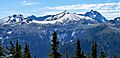
Icy Peak, Ruth Mountain, Mt. Shuksan from northeast
-
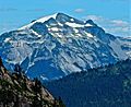
Ruth Mountain, west aspect
-
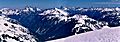
Ruth Mountain summit vista. Peaks include Tomyhoi Peak, Mount Larrabee, Mount Chardonnay, Slesse Mountain, Hannegan Peak, and Mount Rexford


