Mount Churchill facts for kids
Quick facts for kids Mount Churchill |
|
|---|---|

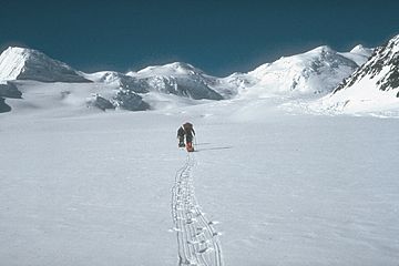
U.S. Geological Survey climbing party ascending the Klutlan Glacier en route to Mount Churchill
|
|
| Highest point | |
| Elevation | 15,638 ft (4,766 m) |
| Prominence | 1,188 ft (362 m) |
| Geography | |
| Parent range | Saint Elias Mountains |
| Topo map | USGS McCarthy B-2 Quadrangle |
| Geology | |
| Mountain type | Stratovolcano with caldera |
| Volcanic arc/belt | Wrangell Volcanic Field |
| Last eruption | 700 AD ± 200 years |
| Climbing | |
| First ascent | August 20, 1951 by R. Gates, J. Lindberg |
| Easiest route | snow climb |
Mount Churchill is a huge volcano in eastern Alaska. It is part of the Saint Elias Mountains and the Wrangell Volcanic Field. This giant mountain is covered in ice. It is the fourth highest volcano in the United States. It is also the seventh highest in all of North America. Mount Churchill is very close to another big volcano called Mount Bona. They are only about 2 miles (3.2 kilometers) apart.
Giant Volcanic Eruptions
Mount Churchill is famous for its past eruptions. It caused two of the biggest volcanic eruptions in North America. These happened over the last 2,000 years. The eruptions created something called the White River Ash. Ash is like fine rock dust that volcanoes throw out.
This ash covers a huge area. It spreads over more than 130,000 square miles (336,700 square kilometers). This area includes eastern Alaska and parts of Canada. One ash cloud, the northern one, was from 1,900 years ago. It traveled over 250 miles (400 kilometers). The other, bigger ash cloud was from about 1,250 years ago. This eastern ash cloud stretched over 500 miles (800 kilometers).
The total amount of ash was enormous. It was about 12 cubic miles (50 cubic kilometers) of ash. This is about 50 times more than the ash from the 1980 Mount St. Helens eruption! You can still see ash layers up to 2 feet (60 centimeters) thick. They are just below the ground along the Alaska Highway.
Finding the Source of the Ash
People first noticed the large ash deposits in 1883. This was near the White and Yukon Rivers. But where the ash came from was a mystery for a long time. In the 1960s, geologists traced the ash back to the Saint Elias Mountains. They thought the ash might have come from a spot hidden under the Klutlan Glacier. This glacier flows east for over 40 miles (64 kilometers). It goes from the Bona-Churchill mountains into Canada.
More detailed studies happened in the 1990s. The United States Geological Survey finally found the answer. They used aerial photos. These photos showed a large, oval-shaped dip in the ice. It was about 2.6 by 1.7 miles (4.2 by 2.7 kilometers) wide. This dip was at 14,500 feet (4,420 meters) high. It was just east of Mount Churchill's top.
This dip was a caldera. A caldera is a large bowl-shaped hollow. It forms when a volcano's top collapses after a huge eruption. Geologists found thick, young pumice deposits there. Pumice is a light, bubbly volcanic rock. These rocks were exactly like the White River Ash. This proved Mount Churchill was the source.
Mountain History
Mount Churchill was first climbed in 1951. R. Gates and J. Lindberg were the first to reach its peak. At that time, the mountain did not have a name. It was just seen as a smaller part of Mount Bona.
The mountain got its name in 1965. The Alaska State Legislature named it after the famous English leader Winston Churchill.
Mount Churchill is a very tall mountain. It is over 15,000 feet (4,572 meters) high. However, it is not as visually striking as some other peaks. This is because it sits on the gentler, northern side of the Bona mountain group. Its peak is also not very far below Mount Bona's peak.
The most common way to climb Mount Churchill today is the South Ridge route. Climbers often combine it with a climb of Mount Bona. They usually start their climb from a special ski-equipped plane. The plane lands on the Klutlan Glacier at about 10,000 feet (3,048 meters) high.
See also
 In Spanish: Monte Churchill para niños
 | William L. Dawson |
 | W. E. B. Du Bois |
 | Harry Belafonte |


