
Mount Ellen (Utah) facts for kids
Quick facts for kids Mount Ellen |
|
|---|---|

Mount Ellen Ridge
|
|
| Highest point | |
| Elevation | 11,527 ft (3,513 m) NAVD 88 |
| Prominence | 5,842 ft (1,781 m) |
| Listing |
|
| Naming | |
| Etymology | Ellen Powell Thompson |
| Geography | |

Mount Ellen
Location in Utah
|
|
| Location | Garfield County, Utah, U.S. |
| Parent range | Henry Mountains |
| Topo map | USGS Mount Ellen |
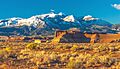
Mount Ellen is a tall mountain located in Garfield County, Utah, in the United States. It's part of the Henry Mountains and is the highest point in that mountain range and in Garfield County.
Contents
About Mount Ellen
Mount Ellen is the highest point in the Henry Mountains. It's also the tallest mountain in Garfield County. You can reach its top with a short hike from a dirt road. The Henry Mountains were the very last mountains in the lower 48 United States to be fully mapped by the USGS. You can see Mount Ellen from far away, even from Mount Peale in the La Sal Mountains located in eastern Utah.
What Makes Mount Ellen Stand Out?
Mount Ellen is known as an "ultra prominent peak." This means it stands out a lot from other mountains nearby. It rises more than 5,000 feet (about 1,500 meters) from the land around it.
The mountain is part of the watershed of the Fremont River. A watershed is an area of land where all the water drains into a single river or lake. The Fremont River joins with Muddy Creek to form the Dirty Devil River. This river then flows into the mighty Colorado River, which eventually reaches the Gulf of California in Mexico.
How Mount Ellen Got Its Name
The Paiute people, who lived in this area, called Mount Ellen "Un tar re." They also sometimes called it "First Mountain."
In June 1872, a man named Almon Harris Thompson climbed to the top of the mountain. He decided to name it after his wife, Ellen. Her full name was Ellen Powell Thompson. She was also the sister of a famous explorer, John Wesley Powell.
A Record-Breaking Signal
Many years ago, on September 10, 1895, something amazing happened on Mount Ellen. A group of soldiers from the U.S. Army Signal Corps set up a special communication system. They used a heliograph, which is a device that sends messages by flashing sunlight with mirrors.
They set up one heliograph on Mount Ellen and another on Mount Uncompahgre in Colorado. Using mirrors that were 8 inches (about 20 cm) wide and telescopes, they sent flashing signals. They managed to communicate over an incredible distance of 183 miles (about 295 kilometers)! This set a world record for visual signaling at the time.
Images for kids
-
Mount Ellen from Highway 95

