Mount Elsay facts for kids
Quick facts for kids Mount Elsay |
|
|---|---|

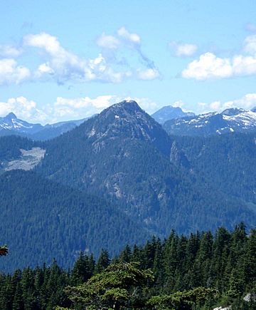
Mount Elsay seen from Eagle Peak in the East
|
|
| Highest point | |
| Elevation | 1,419 m (4,656 ft) |
| Prominence | 254 m (833 ft) |
| Geography | |
| Location | British Columbia, Canada |
| Parent range | Fannin Range, North Shore Mountains, Pacific Ranges |
| Topo map | NTS 92G/07 |
| Climbing | |
| First ascent | 1909 Unnamed BCMC party |
| Easiest route | trail |
Mount Elsay is a cool mountain in southwestern British Columbia, Canada. It's found inside Mount Seymour Provincial Park in the District of North Vancouver. This mountain is part of the North Shore Mountains. It stands tall at about 1,419 meters (4,656 feet) above Indian Arm. The mountain gets its name from a nearby lake and creek, which might have been named by a Scottish settler.
Contents
Mount Elsay's History
Many people used to think Mount Elsay was first called Mount Jarrett. They thought it was named after George Jarrett, who was the first secretary of the British Columbia Mountaineering Club (BCMC) in 1909. But that's not quite right! The name Jarrett was actually given to a different peak nearby, which is sometimes called Deacon Peak.
The first time people officially climbed Mount Elsay was on May 6, 1923. A large group of 29 hikers from the BCMC made the climb. They were led by a famous BCMC leader named Tom Fyles. He was born in England in 1887 and passed away in 1979. There's even a mountain named after him, Mount Fyles, near Bella Coola!
Hiking Mount Elsay
Mount Elsay is not as busy as its neighbor, Mount Seymour. But it's still a great place for an adventure! There are two main ways to hike up Mount Elsay. The best way to explore is to go up one path and come back down the other.
West Trail Route
To find the West Trail, you first hike towards Mount Seymour. Then, when you reach the dip between Second and Third Peaks, you turn left (west). This path is a bit rough and not always clearly marked. It takes you around the west side of Mount Seymour. You'll cross a small valley below Runner Peak. After that, the trail goes uphill to a ridge, and then you'll find a rocky section leading to the top.
Elsay Lake Trail Route
Another way to reach Mount Elsay is by taking the Elsay Lake Trail. This trail goes to the east of Mount Seymour. You'll cross a few areas with loose rocks. Then, you'll go up a large slope made of small, broken rocks. Make sure to stay to the right towards the lowest part of the ridge. This path will eventually join the West Trail on the mountain's south side.
If you want to go to Vicar Lakes, Mount Bishop, or the Indian Arm Trail, you'll turn left shortly after the ridge starts to go up towards Mount Elsay. Remember, this area is wild and rugged. It's important to be careful and have some hiking experience before you go.
Plane Crash Discovery
On April 28, 1947, a plane called a Lockheed 18 Lodestar went missing in southwestern British Columbia. It was a Trans-Canada Air Lines (now Air Canada) flight with 15 people on board. Sadly, no one survived. The crash site was found many years later, in September 1994, right on Mount Elsay.
 | Tommie Smith |
 | Simone Manuel |
 | Shani Davis |
 | Simone Biles |
 | Alice Coachman |


