Mount Erie (Washington) facts for kids
Quick facts for kids Mount Erie |
|
|---|---|

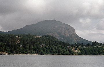
Mount Erie from Burrows Bay
|
|
| Highest point | |
| Elevation | 1,273 ft (388 m) NAVD 88 |
| Prominence | 1,273 ft (388 m) |
| Geography | |
| Location | Skagit County, Washington, U.S. |
| Climbing | |
| Easiest route | Paved road |
Mount Erie is a mountain located on Fidalgo Island in Skagit County, Washington, United States. It's a public park managed by the city of Anacortes. You can find it in the southern part of the Anacortes Community Forest Lands.
This mountain was named in 1841 by the Wilkes Expedition. It got its name from the Battle of Lake Erie. People started exploring Mount Erie for climbing in the 1960s. Local climbers, like Dallas Kloke, were among the first.
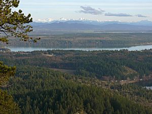
Mount Erie is famous for its rock climbing spots. It also offers amazing views from its top. You can reach the summit by driving up a single-lane, paved road. At 1,273 feet (388 meters) tall, Mount Erie is the highest point on Fidalgo Island. On a clear day, you can see Mount Baker, about 43 miles (69 km) away. You might also spot Mount Rainier, which is about 117 miles (188 km) to the southeast.
How Mount Erie Was Formed
Mount Erie is part of a special area called the Fidalgo Complex. It is mostly made of a rock called diorite. This rock contains minerals like feldspar and hornblende. Scientists believe Mount Erie formed during the Jurassic period, which was about 155 to 170 million years ago.
During that time, hot, melted rock pushed up from deep inside the Earth. This created large bodies of diorite rock. This process also helped form the island chains around the San Juan Islands. Later, the land was pushed up and worn down by wind and water. This exposed the diorite rocks we see today.
Over time, other rocks called gabbro dikes pushed into the diorite. This suggests the area might have been underwater at times. This constant pushing up, wearing down, and adding new rock helped create the unique rock formations in the San Juan Islands.
Mount Erie and Glaciers
During the Quaternary Period, which includes the last 2.6 million years, glaciers covered this area many times. These huge sheets of ice moved across the land. As they moved, they scraped and carved the rocks.
You can still see signs of this glacial activity on Mount Erie. There are large scratch marks, called striations, on the diorite and gabbro rocks at the summit. These marks show where the glaciers dragged rocks across the mountain. The periods of ice were separated by warmer times, and this process continues even today.
Some large rocks found far from Mount Erie actually came from here. These are called glacial erratics. For example, Big Rock in Coupeville, Washington, and the Wedgwood Rock in Seattle, Washington, were both carried by glaciers from Mount Erie to their current spots.
In Popular Culture
The American indie rock band Mount Eerie is named after this mountain. Before 2004, the band was known as The Microphones. The main singer and songwriter, Phil Elverum, grew up near Mount Erie.
 | Lonnie Johnson |
 | Granville Woods |
 | Lewis Howard Latimer |
 | James West |


