
Mount Fryatt facts for kids
Quick facts for kids Mount Fryatt |
|
|---|---|
 |
|
| Highest point | |
| Elevation | 3,361 m (11,027 ft) |
| Prominence | 1,608 m (5,276 ft) |
| Parent peak | Mount Edith Cavell |
| Listing | |
| Geography | |

Mount Fryatt
Location in Alberta

Mount Fryatt
Location in Canada
|
|
| Location | Alberta, Canada |
| Parent range | Canadian Rockies |
| Topo map | NTS 83C/12 |
| Climbing | |
| First ascent | 1926 J. Hickson; H. Palmer; H. Fuhrer |
| Easiest route | South-West Face (Normal Route) II 5.4 West Ridge Direct III 5.8 |
Mount Fryatt is a tall mountain located in Alberta, Canada. It stands as the 26th highest peak in Alberta! This impressive mountain is found within Jasper National Park, nestled between the Athabasca River and Whirlpool River. It was named in 1920 after Captain Charles Fryatt, a brave British merchant seaman from World War I.
How Mount Fryatt Was Formed
Mount Fryatt is made up of different kinds of sedimentary rock. This rock was formed over millions of years, from the Precambrian to the Jurassic periods. Imagine shallow seas covering this area long, long ago. Tiny bits of sand, mud, and shells settled at the bottom of these seas, slowly turning into layers of rock.
Later, during a time called the Laramide orogeny, huge forces pushed these rock layers. It was like giant plates of the Earth's crust slowly crashing into each other. This pushing caused the older sedimentary rock to be lifted up and even pushed over the top of younger rock. This is how Mount Fryatt and many other mountains in the Canadian Rockies were created!
Weather and Climate at Mount Fryatt
Mount Fryatt has a subarctic climate. This means it has very cold, snowy winters and mild summers. If you visit, be prepared for chilly weather! Temperatures can drop below -20 °C (which is -4 °F). With the wind, it can feel even colder, sometimes below -30 °C (-22 °F).
All the rain and melting snow that falls on Mount Fryatt eventually flows into nearby streams and rivers. This water then drains into the Athabasca River and its smaller branches.
Images for kids
-
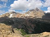
Mount Fryatt seen from Fryatt Valley
-
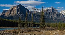
Mount Fryatt behind its smaller peaks, as seen from the Icefields Parkway


