
Mount Katmai facts for kids
Quick facts for kids Mount Katmai |
|
|---|---|

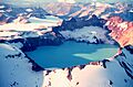
Mount Katmai and its crater lake in September 1980.
|
|
| Highest point | |
| Elevation | 6,716 ft (2,047 m) |
| Geography | |
| Location | Katmai National Park and Preserve, Alaska, United States |
| Parent range | Aleutian Range |
| Topo map | USGS Mount Katmai B-3 |
| Geology | |
| Mountain type | Stratovolcano |
| Volcanic arc/belt | Aleutian Arc |
| Last eruption | June to July 1912 |
| Climbing | |
| Easiest route | Basic snow/ice climb |
Mount Katmai (which is Катмай in Russian) is a very large stratovolcano, also known as a composite volcano. It's located on the Alaska Peninsula in southern Alaska, inside the beautiful Katmai National Park and Preserve.
This volcano is about 6.3 miles (10.1 kilometers) wide. It has a huge, lake-filled bowl at its top called a caldera. This caldera is about 2 by 3 miles (3.2 by 4.8 kilometers) in size. It formed during a massive eruption in 1912, which was caused by another nearby volcano called Novarupta. The highest point of the caldera rim reaches about 6,716 feet (2,047 meters) above sea level. The lake inside the caldera is quite deep, and small glaciers have even formed on benches beside it.
What is Mount Katmai Made Of?


Mount Katmai is one of five volcanoes that surround the Novarupta volcano. Novarupta was the source of a huge eruption in 1912. This eruption was so powerful it scored a 6 on the Volcanic Explosivity Index (VEI).
Mount Katmai itself is mostly made up of hardened lava flows and pyroclastic rocks. These are rocks formed from volcanic ash and fragments. A lot of the volcano is covered in snow and ice. Several valley glaciers also flow down its sides.
The volcano sits on top of older sedimentary rocks. These rocks are from the Late Jurassic period. You can see them near the caldera rim and in other parts of the volcano.
Mount Katmai's Big Eruption in 1912
Before 1912, not much was known about Mount Katmai's history. Old maps suggested its top was once about 7,500 feet (2,300 meters) high. Local people said that one of the volcanoes in the area sometimes "smoked."
From June 6 to 9, 1912, the biggest volcanic eruption in Alaska's recorded history happened. It was also the largest measured eruption of the 20th century! This massive event created the large caldera we see today at the top of Mount Katmai.
The actual eruption happened at a different vent, about 6 miles (9.7 kilometers) west of Mount Katmai. This vent belonged to the Novarupta volcano. Over 60 hours, Novarupta erupted a huge amount of ash and rock. This caused the ground beneath Mount Katmai to collapse, forming its caldera.
The eruption created a massive cloud of ash and gas. It made the sky dark for people living in the town of Kodiak. Ash fell everywhere, and people had to shelter on a ship in the harbor. The captain decided it was too dangerous to try to leave.
After the collapse, a small dacitic lava dome called Horseshoe Island formed on the caldera floor. This was the only new material that came out of Katmai during this eruption. It was seen in 1916 but has since been covered by the crater lake.
In 1919, scientists saw a lake covering most of the caldera floor. But by 1923, the lake was gone! Instead, there were many fumaroles (steam vents) and mud pots. The lake has since refilled and is now over 800 feet (240 meters) deep. You can even find Pumice (a light, porous volcanic rock) floating on Naknek Lake nearby.
Images for kids
-
Mount Katmai and its crater lake in September 1980.
-
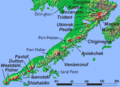
A map showing volcanoes on the Alaska Peninsula.
-
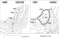
How Katmai's caldera looked before and after the 1912 eruption.
See also
 In Spanish: Monte Katmai para niños
