Mount Kynoch, Queensland facts for kids
Quick facts for kids Mount KynochToowoomba, Queensland |
|||||||||||||||
|---|---|---|---|---|---|---|---|---|---|---|---|---|---|---|---|

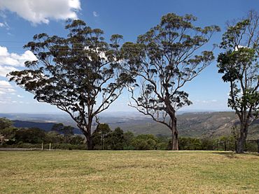
View southeastwards from Mount Kynoch lookout, 2014
|
|||||||||||||||
| Population | 271 (2021 census) | ||||||||||||||
| • Density | 82.1/km2 (213/sq mi) | ||||||||||||||
| Postcode(s) | 4350 | ||||||||||||||
| Area | 3.3 km2 (1.3 sq mi) | ||||||||||||||
| Time zone | AEST (UTC+10:00) | ||||||||||||||
| Location |
|
||||||||||||||
| LGA(s) | Toowoomba Region | ||||||||||||||
| State electorate(s) | Toowoomba North | ||||||||||||||
|
|||||||||||||||
Mount Kynoch is a small rural area in the Toowoomba Region of Queensland, Australia. It's a quiet place where 271 people lived in 2021.
Contents
Exploring Mount Kynoch's Location
Mount Kynoch is about 6 kilometers (3.7 miles) north of the Toowoomba city center.
Mountains and Railways
The famous Great Dividing Range runs through the eastern part of Mount Kynoch. The highest point in the area is a mountain also called Mount Kynoch. It stands tall at 709 meters (2,326 feet) above sea level.
The main railway line forms the eastern edge of Mount Kynoch. There's a train stop called Rangeview railway station that serves the area.
Major Roads
The New England Highway passes right through Mount Kynoch. It comes in from the south (near Harlaxton) and continues north (towards Blue Mountain Heights).
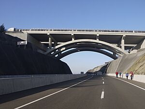
There's also the Toowoomba Bypass, a major road that enters from the southeast (near Ballard). It goes under the New England Highway without connecting to it, then leaves Mount Kynoch to the south.
A Look at Mount Kynoch's Past
The name "Kynoch" was first used for a special measuring point on a mountain once known as Stony Pinch. Later, both the mountain and the area were named Mount Kynoch. This was done to honor John Kynoch, who was an early leader of the Shire of Highfields.
Who Lives in Mount Kynoch?
In 2016, Mount Kynoch had 237 people living there. By 2021, the population grew slightly to 271 people.
Learning Opportunities Near Mount Kynoch
Mount Kynoch doesn't have its own schools. For primary school, kids usually go to nearby Harlaxton or Highfields. For high school, students attend Toowoomba State High School in Mount Lofty or Wilsonton State High School in Wilsonton Heights.
Important Services in Mount Kynoch
Water Treatment Plant
At the top of Mount Kynoch, you'll find the Mount Kynoch Water Treatment Plant. This important facility cleans water for the community. It gets its water from three dams: Cooby Dam, Cressbrook Dam, and Perseverance Dam.
Fun Places to Visit in Mount Kynoch
There are a few parks in the area where you can relax and play:
- Hillsdale Crescent Road Park
- Shuttlewood Court Park
Amazing Lookouts
Mount Kynoch is home to two fantastic lookouts, one on each side of the New England Highway.
- The northbound lookout is on Shuttlewood Court, right next to the water treatment plant. It's a great spot with picnic tables and park facilities.
- The southbound lookout offers amazing views over the Lockyer Valley to the east. It's a perfect place to stop and enjoy the scenery.
 | James Van Der Zee |
 | Alma Thomas |
 | Ellis Wilson |
 | Margaret Taylor-Burroughs |


