Cranley, Queensland facts for kids
Quick facts for kids CranleyToowoomba, Queensland |
|||||||||||||||
|---|---|---|---|---|---|---|---|---|---|---|---|---|---|---|---|
| Population | 2,281 (2021 census) | ||||||||||||||
| • Density | 221.5/km2 (574/sq mi) | ||||||||||||||
| Postcode(s) | 4350 | ||||||||||||||
| Area | 10.3 km2 (4.0 sq mi) | ||||||||||||||
| Time zone | AEST (UTC+10:00) | ||||||||||||||
| Location |
|
||||||||||||||
| LGA(s) | Toowoomba Region | ||||||||||||||
| State electorate(s) | Toowoomba North | ||||||||||||||
| Federal Division(s) | Groom | ||||||||||||||
|
|||||||||||||||
Cranley is a rural area in the Toowoomba Region, Queensland, Australia. A "locality" is like a small community or district. In 2021, about 2,281 people lived in Cranley.
Contents
Where is Cranley?
Cranley is located about 6 kilometers (4 miles) north-west of the Toowoomba city center. The Gowrie Creek forms its northern and eastern borders. Boundary Road is its western border.
Most of Cranley has small farms and homes that are spread out. It's a very open area. There are a few special places here. These include the Baillie Henderson Hospital, which helps people with mental health. There is also a waste water treatment plant and a retirement village called Palm Lake Resort.
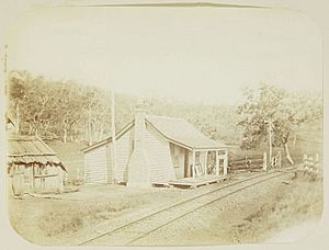
There were once several railway stations in Cranley. They were all on the Southern and Western railway lines. These stations are now closed. They included Pengarry, Wetalla, and Cranley railway stations.
Cranley's History
The Cranley railway station was built in the 1870s. It was part of the Southern railway line that went from Toowoomba to Warwick. The station was named after James Cranley. He was a farmer and land owner in the area.
James Cranley was also a local council member in Toowoomba. He served from 1864 to 1866. He was born in Ireland around 1811. He moved to Australia in 1853 with his family. He settled near Toowoomba around 1857. He passed away in Toowoomba in 1890.
A big new road project started in Cranley in 2016. This road is called the Toowoomba Second Range Crossing. It opened in 2019. It is now the new route for the Warrego Highway. This road helps traffic go around the city center of Toowoomba. It connects the Warrego Highway and the New England Highway. This means less traffic in the middle of Toowoomba. It might also lead to new businesses opening in Cranley.
Population Growth
The number of people living in Cranley has grown quite a bit over the years.
- In 2006, there were 724 people.
- In 2011, the population grew to 852 people.
- By 2016, it had increased to 1,446 people.
- In 2021, the population reached 2,281 people.
Schools Near Cranley
There are no schools directly in Cranley. However, there are many schools nearby.
The closest government primary schools are:
- Rockville State School in Rockville (to the south-east)
- Fairview Heights State School in Wilsonton (to the south)
- Gowrie State School in Gowrie Junction (to the north-west)
- Harlaxton State School in Harlaxton (to the south-east)
The closest government high schools are:
- Wilsonton State High School in Wilsonton Heights (to the south)
- Toowoomba State High School in Mount Lofty (to the south-east)
Important Places
One place in Cranley is listed for its heritage. This means it's an important historical site.
- Baillie Henderson Hospital, located at 1 Hogg Street.
 | Kyle Baker |
 | Joseph Yoakum |
 | Laura Wheeler Waring |
 | Henry Ossawa Tanner |


