Mount Michener facts for kids
Quick facts for kids Mount Michener |
|
|---|---|

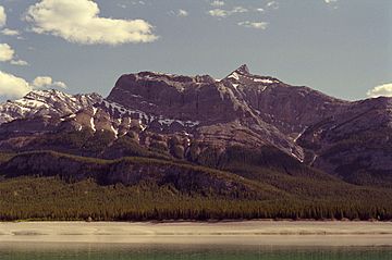
North face from Abraham Lake
|
|
| Highest point | |
| Elevation | 2,545 m (8,350 ft) |
| Prominence | 564 m (1,850 ft) |
| Parent peak | Kista Peak (2576 m) |
| Geography | |
| Location | Alberta, Canada |
| Parent range | Ram Range |
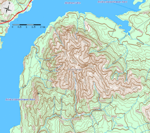
| Topo map | NTS 83C/01 |
Mount Michener is a tall mountain located in Alberta, Canada. It stands 2,545 meters (about 8,350 feet) high. This impressive peak is part of the Canadian Rockies, a huge mountain range in western North America.
The mountain is found on the eastern edge of the Rockies and is the northern part of the Ram Range. You can easily see Mount Michener's north, west, and south sides from the David Thompson Highway, especially when driving near Abraham Lake.
The mountain was officially named in 1982 after Daniel Roland Michener. He was an important person in Canada, serving as the Governor General of Canada from 1967 to 1974. Before its current name, the mountain had other interesting names like Eye Opener Mountain and Phoebe's Teat. These names came from stories about a woman from Rocky Mountain House who visited miners in Nordegg during the 1930s.
How Mount Michener Was Formed
The Rocky Mountains, including Mount Michener, were created a very long time ago. This process started in the Late Cretaceous Period and finished in the Early Tertiary Period. Imagine giant pieces of the Earth's crust pushing against each other.
This immense pressure caused huge amounts of rock to be pushed upwards along cracks in the Earth, called fault lines. If you look closely at the top of Mount Michener, you can see twisted layers of rock. These "contorted beds" are clear signs of the incredible forces that shaped the mountain.
Mount Michener also has a system of limestone caves hidden inside. However, these caves have not been fully explored or documented yet.
 | Percy Lavon Julian |
 | Katherine Johnson |
 | George Washington Carver |
 | Annie Easley |


