Nordegg facts for kids
Quick facts for kids
Nordegg
Brazeau
|
|
|---|---|
|
Hamlet
|
|

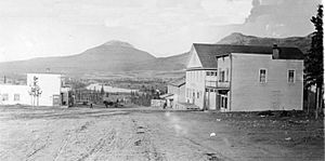
Nordegg, 1914
|
|
| Country | Canada |
| Province | Alberta |
| Region | Central Alberta |
| Census Division | No. 9 |
| Municipal district | Clearwater County |
| Founded | 1914 |
| Named for | Martin Nordegg |
| Elevation | 1,287 m (4,222 ft) |
| Population
(1986)
|
|
| • Total | 53 |
| Time zone | UTC−7 (MST) |
| • Summer (DST) | UTC−6 (MDT) |
| Postal code span |
T0M 2H0
|
| Area code(s) | +1-403 |
| Highways | Highway 11 |
| Waterways | Lake Abraham, Shunda Creek |
Nordegg is a small community known as a hamlet in west-central Alberta, Canada. It is located in the beautiful North Saskatchewan River valley, nestled in the foothills of the Canadian Rockies. Nordegg is just east of where the David Thompson Highway meets the Highway 734 spur.
This area was once a busy coal mining town. It was named after Martin Nordegg, who helped start the coal operations there. The name "Nordegg" likely means "North Corner" in a German language. For a while, the local train station was called Brazeau, but the post office has always been known as Nordegg. The name Brazeau is not used anymore.
Contents
History
The Start of Nordegg
In 1907, a man named Martin Cohn (who later changed his last name to Nordegg) found large amounts of coal near the Blackstone, Bighorn, and North Saskatchewan rivers. He worked with a company called Brazeau Collieries Ltd. to mine this coal. The Canadian Northern Railway (which later became part of the Canadian National Railway) agreed to build a train line to the area. This led to the creation of Nordegg, a town built specifically for coal mining.
A small camp was set up at the future town site in 1911. Coal production began in 1912, and the train line, called the Brazeau Branch, reached the town in 1913. Before the train, the only way to get to Nordegg was by horse. In 1914, the town was officially founded as one of Alberta's first planned communities. It was named in honor of Martin Nordegg's hard work by railway builder William Mackenzie.
Challenges and Growth
When World War I started, German businesses in Canada faced difficulties. Martin Nordegg was allowed to stay and manage the mine for a while. However, in 1915, he was asked to leave Canada. He returned in 1921 but no longer worked with the mine.
The coal found at Nordegg is part of the Gates Formation. Miners mainly worked in two coal layers, called No. 2 and No. 3 Seams. These layers were about 7.75 feet and 15.92 feet thick. They were separated by about 123 feet of rock. The coal layers sloped at an angle of 12 degrees. Miners used underground methods, digging out "rooms" and leaving "pillars" of coal to support the roof.
Coal production reached its highest point in 1923, with about 500,000 short tons of coal mined. At that time, about 800 people worked at the mine. In 1937, five small briquetting plants were added. These plants turned powdery, fine coal into solid blocks called briquettes, which were easier to sell.
Mine Disaster and Closure
On October 31, 1941, a large explosion happened in the No. 3 Mine. Sadly, 29 miners lost their lives. Mining started again six weeks later. In 1942, the Nordegg mine was one of Alberta's top coal producers. The town's population grew to about 2,500 people in the early 1940s. A surface mining operation, where coal is dug from the ground's surface, was added in 1946.
In 1950, a fire destroyed the coal processing building, called a tipple, and five wooden briquetting plants. A new, more modern briquetting plant made of metal was built. It started working in late 1951. However, the company had taken on a large debt to build it. The demand for coal began to drop. This was mainly because railroads were replacing steam locomotives with diesel engines, which did not use coal. Because of this, Brazeau Collieries closed permanently in 1955. Most people left Nordegg after the mine closed, but a few families chose to stay.
The coal reserves at Nordegg were not completely used up, but mining never started again. In total, about 9.6 million tonnes of a type of coal called bituminous coal were produced.
Climate
Nordegg has a subarctic climate (Dfc). This type of climate is also considered a subalpine climate because of Nordegg's high elevation. Places at the same latitude but lower down usually have warmer weather. Summers in Nordegg are mild, with a few warm days. Winters are cold and snowy.
| Climate data for Nordegg, Alberta (1981–2010 normals) | |||||||||||||
|---|---|---|---|---|---|---|---|---|---|---|---|---|---|
| Month | Jan | Feb | Mar | Apr | May | Jun | Jul | Aug | Sep | Oct | Nov | Dec | Year |
| Record high °C (°F) | 16.7 (62.1) |
19.5 (67.1) |
17.2 (63.0) |
26.0 (78.8) |
29.5 (85.1) |
37.2 (99.0) |
32.0 (89.6) |
32.2 (90.0) |
31.0 (87.8) |
26.0 (78.8) |
18.3 (64.9) |
15.5 (59.9) |
37.2 (99.0) |
| Mean daily maximum °C (°F) | −2.6 (27.3) |
0.0 (32.0) |
3.5 (38.3) |
8.8 (47.8) |
13.7 (56.7) |
17.5 (63.5) |
20.4 (68.7) |
20.0 (68.0) |
15.1 (59.2) |
9.2 (48.6) |
0.9 (33.6) |
−3.2 (26.2) |
8.6 (47.5) |
| Daily mean °C (°F) | −9.7 (14.5) |
−7.6 (18.3) |
−4.0 (24.8) |
1.6 (34.9) |
6.4 (43.5) |
10.3 (50.5) |
12.8 (55.0) |
12.1 (53.8) |
7.4 (45.3) |
2.2 (36.0) |
−5.6 (21.9) |
−9.7 (14.5) |
1.4 (34.4) |
| Mean daily minimum °C (°F) | −16.8 (1.8) |
−15.2 (4.6) |
−11.5 (11.3) |
−5.5 (22.1) |
−0.8 (30.6) |
3.0 (37.4) |
5.1 (41.2) |
4.2 (39.6) |
−0.3 (31.5) |
−4.9 (23.2) |
−12.0 (10.4) |
−16.2 (2.8) |
−5.9 (21.4) |
| Record low °C (°F) | −47.2 (−53.0) |
−47.0 (−52.6) |
−40.5 (−40.9) |
−26.0 (−14.8) |
−16.5 (2.3) |
−12.2 (10.0) |
−6.7 (19.9) |
−6.7 (19.9) |
−16.0 (3.2) |
−35.0 (−31.0) |
−43.0 (−45.4) |
−45.0 (−49.0) |
−47.2 (−53.0) |
| Average precipitation mm (inches) | 22.1 (0.87) |
18.0 (0.71) |
26.2 (1.03) |
34.2 (1.35) |
68.2 (2.69) |
105.4 (4.15) |
106.7 (4.20) |
86.8 (3.42) |
63.0 (2.48) |
32.6 (1.28) |
21.8 (0.86) |
18.3 (0.72) |
603.3 (23.76) |
| Average rainfall mm (inches) | 0.0 (0.0) |
0.5 (0.02) |
1.3 (0.05) |
9.7 (0.38) |
47.0 (1.85) |
105.3 (4.15) |
106.7 (4.20) |
86.8 (3.42) |
57.3 (2.26) |
11.2 (0.44) |
0.9 (0.04) |
0.1 (0.00) |
426.8 (16.81) |
| Average snowfall cm (inches) | 23.4 (9.2) |
18.4 (7.2) |
27.6 (10.9) |
25.8 (10.2) |
20.2 (8.0) |
0.1 (0.0) |
0.0 (0.0) |
0.0 (0.0) |
5.7 (2.2) |
21.6 (8.5) |
22.8 (9.0) |
18.5 (7.3) |
184.1 (72.5) |
| Average precipitation days (≥ 0.2 mm) | 7.0 | 6.5 | 8.3 | 9.5 | 13.7 | 16.9 | 16.7 | 16.0 | 12.8 | 9.3 | 7.1 | 6.5 | 130.3 |
| Average rainy days | 0.0 | 0.24 | 0.79 | 4.9 | 12.3 | 16.9 | 16.7 | 16.0 | 12.3 | 5.7 | 0.54 | 0.08 | 86.4 |
| Average snowy days (≥ 0.2 cm) | 7.1 | 6.3 | 7.8 | 6.5 | 3.7 | 0.09 | 0.0 | 0.0 | 1.6 | 4.8 | 6.8 | 6.5 | 51.2 |
| Source: Environment Canada | |||||||||||||
Population History
|
|||||||||||||||||||||||||||||||||
The population of Nordegg has changed a lot over the years. In the 1986 Census, which is a count of people done by Statistics Canada, Nordegg had 53 residents.
What to See and Do
Many of the old coal handling, processing, and support buildings at Nordegg are still standing today. These buildings were recognized as a Provincial Historic Resource in 1992, meaning they are important to the history of Alberta. In 2002, they were also named a National Historic Site of Canada, showing their importance to all of Canada.
During the summer months, you can take guided tours of these old surface facilities. Unfortunately, you cannot tour the underground mine tunnels because most of them have collapsed. However, about 16 feet (5 meters) into the entrances of the No. 2 and No. 3 Mines have been fixed up, and you can go inside that short distance. Beyond that, the entrances are blocked for safety.
Nordegg is also seeing new developments. A new mountain community, called the North Nordegg Subdivision, is being built north of Highway 11. Clearwater County has also shared plans to redevelop the downtown area of Nordegg, much of it on the same land where the original town once stood.
 | William Lucy |
 | Charles Hayes |
 | Cleveland Robinson |


