
Mount Pocono, Pennsylvania facts for kids
Quick facts for kids
Borough of Mount Pocono
|
||
|---|---|---|

Mount Pocono Knob Lookout, looking east toward Delaware Water Gap.
|
||
|
||

Location of Mount Pocono in Monroe County, Pennsylvania.
|
||

Borough of Mount Pocono
Location in Pennsylvania

Borough of Mount Pocono
Location in the United States
|
||
| Country | United States | |
| State | Pennsylvania | |
| County | Monroe | |
| Incorporated | 1927 | |
| Area | ||
| • Total | 3.46 sq mi (8.95 km2) | |
| • Land | 3.45 sq mi (8.95 km2) | |
| • Water | 0.00 sq mi (0.01 km2) | |
| Elevation | 1,988 ft (606 m) | |
| Population
(2020)
|
||
| • Total | 3,089 | |
| • Density | 894.33/sq mi (345.31/km2) | |
| Time zone | UTC-5 (EST) | |
| • Summer (DST) | UTC-4 (EDT) | |
| ZIP Code |
18344
|
|
| Area codes | 570 and 272 | |
| FIPS code | 42-51912 | |

Mount Pocono is a small town, called a borough, in Monroe County, Pennsylvania. It's a busy spot for roads and welcomes many tourists. These visitors come to enjoy the beautiful Pocono Mountains area. In 2020, about 3,083 people lived here.
Contents
Where is Mount Pocono?
Mount Pocono is located at 41°7′23″N 75°21′34″W / 41.12306°N 75.35944°W. It's almost in the middle of Monroe County. This county is part of the larger Pocono Mountains region in Northeastern Pennsylvania.
The town covers about 3.5 square miles (9.0 square kilometers) of land. It's a great place to explore the natural beauty of the Poconos.
Who Lives in Mount Pocono?
| Historical population | |||
|---|---|---|---|
| Census | Pop. | %± | |
| 1930 | 466 | — | |
| 1940 | 648 | 39.1% | |
| 1950 | 619 | −4.5% | |
| 1960 | 935 | 51.1% | |
| 1970 | 1,019 | 9.0% | |
| 1980 | 1,237 | 21.4% | |
| 1990 | 1,795 | 45.1% | |
| 2000 | 2,742 | 52.8% | |
| 2010 | 3,170 | 15.6% | |
| 2020 | 3,083 | −2.7% | |
| 2021 (est.) | 3,097 | −2.3% | |
| Sources: | |||
In 2010, there were 3,170 people living in Mount Pocono. There were 1,225 homes. About 32% of these homes had children under 18 living there. The average family size was about three people.
The population includes people of different backgrounds. About 58.6% were White, and 18.6% were Black or African American. About 17.7% of the population was Hispanic or Latino.
Learning in Mount Pocono
The Pocono Mountain School District (PMSD) is in charge of public schools in Mount Pocono. Students attend schools in the East district of PMSD.
- Pocono Mountain East High School is for students in grades 9-12.
- Pocono Mountain East Junior High School is for students in grades 7-8.
- Swiftwater Intermediate School teaches students in grades 4-6.
- Swiftwater Elementary Center is for the youngest students, from kindergarten to third grade.
The school district also has an online learning program called the PMSD Cyber Program. It's a free option for students in all grades.
Mount Pocono's Past
In the early 1800s, people first settled in this area. They mostly used the land for cutting down trees (lumbering). A post office called "New Mount Pocono" opened in 1848.
The town's name changed to "Forks" in 1864. This was because of a special five-way intersection. Here, Pennsylvania Route 611 and Pennsylvania Route 940 cross, and Pennsylvania Route 196 begins. In 1886, the name changed back to "Mount Pocono."
Trains from New York City and Philadelphia started coming to Mount Pocono. This made the town a popular summer resort. People came for the fresh mountain air, clean spring water, fancy hotels, and great fishing.
Mount Pocono used to be part of another area called Coolbaugh Township. But in 1927, Mount Pocono became its own official borough.
The town was very popular until the mid-1900s. Many of the big resort hotels either burned down or closed. Train service for passengers also stopped in 1965.
One famous place was Mount Airy Lodge in nearby Paradise Township. It was a huge resort with 895 rooms. It was a popular place for honeymoons, known for its heart-shaped bathtubs. It closed in 2001 and was later taken down.
Later, in 2004, Casino gambling in Pennsylvania became legal. A new place called Mount Airy Casino Resort was built on the old Mount Airy Lodge site. It opened in 2007.
Today, Mount Pocono is a main shopping area for the northern part of Monroe County. You can find many different stores here. Many local businesses are part of the Mount Pocono Association.
Old Hotels in Mount Pocono
Mount Pocono was once famous for its many large hotels. Here are a few examples:
- Pine Hill Lodge (opened 1875)
- Pocono Mountain House (opened 1878, burned 1973)
- Princess Poconita Resort (opened 1880)
- Mount Airy Lodge (opened 1898, closed 2001)
Getting Around Mount Pocono
Roads and Highways
_from_the_overpass_for_the_rail_line_just_south_of_Fork_Street_in_Mount_Pocono,_Monroe_County,_Pennsylvania.jpg)
Mount Pocono has about 21.55 miles of public roads. Some are kept up by the state, and others by the borough itself.
Three main highways serve Mount Pocono:
- Pennsylvania Route 196
- Pennsylvania Route 611
- Pennsylvania Route 940
These roads help people travel through and around the town.
Railroad

The Delaware, Lackawanna and Western Railroad used to run through Mount Pocono. It connected the town to New York City. A train station was built in 1886. Most of it was taken down in 1937 when the highway was made wider.
Regular passenger train service stopped in 1965. Now, the tracks are used by freight trains. Sometimes, special excursion trains from Steamtown National Historic Site also use them.
Bus Service
The Monroe County Transit Authority (MCTA) has bus routes in Monroe County. The Blue Route serves Mount Pocono's Main Street. It goes north to Tobyhanna and south to Tannersville. You can connect to other MCTA routes at the Giants Supermarket.
Long-distance bus companies like Martz Trailways and Greyhound Lines also serve Mount Pocono. Martz Trailways connects Mount Pocono to New York City. Greyhound Lines connects it to Philadelphia and Scranton.
Air Travel
The Pocono Mountains Municipal Airport is located just two miles north of Mount Pocono.
News and Media
People in Mount Pocono can read local news from several sources:
- The Pocono Record is a daily newspaper. It covers news from the Poconos, including Mount Pocono.
- The Pocono Plateau is a community newspaper. It covers Mount Pocono and nearby areas. It's given out for free at stores and restaurants.
- The Boro & Towne News started as an online news site for Mount Pocono. It now prints a newspaper every other week. It is mailed to homes and businesses in Mount Pocono and nearby towns.
Mount Pocono's Weather
Mount Pocono has a temperate climate. This means it has warm summers and cold winters. It rains or snows throughout the year.
Most summer days are comfortable. But sometimes it can get very hot and humid. The highest temperature ever recorded was 103°F (39°C). July usually has the most thunderstorms. October is often the wettest month, sometimes with rain from tropical storms.
Winters are cold. The average coldest temperature in a year is about -10.1°F (-23.4°C). The coldest temperature ever recorded was -35°F (-37°C). It often snows a lot, especially from December to March. Large snowstorms with 12 inches (30 cm) or more of snow happen almost every year.
| Climate data for Mount Pocono, Pennsylvania (Pocono Mountains Municipal Airport), 1991–2020 normals, extremes 1901–present | |||||||||||||
|---|---|---|---|---|---|---|---|---|---|---|---|---|---|
| Month | Jan | Feb | Mar | Apr | May | Jun | Jul | Aug | Sep | Oct | Nov | Dec | Year |
| Record high °F (°C) | 69 (21) |
70 (21) |
81 (27) |
88 (31) |
94 (34) |
92 (33) |
103 (39) |
95 (35) |
95 (35) |
89 (32) |
77 (25) |
67 (19) |
103 (39) |
| Mean maximum °F (°C) | 54.3 (12.4) |
53.2 (11.8) |
62.7 (17.1) |
76.9 (24.9) |
83.2 (28.4) |
85.7 (29.8) |
87.9 (31.1) |
85.9 (29.9) |
83.1 (28.4) |
74.7 (23.7) |
65.1 (18.4) |
55.6 (13.1) |
89.2 (31.8) |
| Mean daily maximum °F (°C) | 30.2 (−1.0) |
33.4 (0.8) |
41.4 (5.2) |
54.6 (12.6) |
65.3 (18.5) |
73.0 (22.8) |
77.7 (25.4) |
75.7 (24.3) |
68.5 (20.3) |
57.1 (13.9) |
45.7 (7.6) |
34.9 (1.6) |
54.8 (12.7) |
| Daily mean °F (°C) | 22.6 (−5.2) |
25.2 (−3.8) |
32.7 (0.4) |
44.4 (6.9) |
55.0 (12.8) |
63.2 (17.3) |
67.9 (19.9) |
66.0 (18.9) |
59.0 (15.0) |
48.0 (8.9) |
37.8 (3.2) |
28.1 (−2.2) |
45.8 (7.7) |
| Mean daily minimum °F (°C) | 15.1 (−9.4) |
16.9 (−8.4) |
24.0 (−4.4) |
34.3 (1.3) |
44.6 (7.0) |
53.4 (11.9) |
58.1 (14.5) |
56.3 (13.5) |
49.6 (9.8) |
38.9 (3.8) |
29.8 (−1.2) |
21.3 (−5.9) |
36.9 (2.7) |
| Mean minimum °F (°C) | −3.5 (−19.7) |
−0.1 (−17.8) |
6.1 (−14.4) |
21.3 (−5.9) |
30.9 (−0.6) |
39.0 (3.9) |
46.8 (8.2) |
45.4 (7.4) |
35.5 (1.9) |
25.7 (−3.5) |
14.0 (−10.0) |
3.9 (−15.6) |
−5.6 (−20.9) |
| Record low °F (°C) | −35 (−37) |
−25 (−32) |
−14 (−26) |
0 (−18) |
18 (−8) |
25 (−4) |
34 (1) |
31 (−1) |
22 (−6) |
12 (−11) |
−2 (−19) |
−22 (−30) |
−35 (−37) |
| Average precipitation inches (mm) | 2.98 (76) |
2.45 (62) |
3.83 (97) |
4.24 (108) |
4.06 (103) |
4.69 (119) |
4.73 (120) |
4.64 (118) |
5.59 (142) |
5.15 (131) |
4.08 (104) |
3.78 (96) |
50.22 (1,276) |
| Average precipitation days (≥ 0.01 in) | 11.4 | 11.6 | 12.9 | 13.9 | 15.6 | 15.2 | 15.1 | 15.1 | 13.4 | 13.4 | 11.4 | 12.3 | 161.3 |
| Source: NOAA | |||||||||||||
Nature and Environment
Mount Pocono is in an area where the main type of natural plant life is Northern Hardwood forest. This means you'll find many trees like oak, maple, and birch.
The best time to see flowers bloom in spring is usually early May. The leaves change to beautiful fall colors in early October. The area is in a plant hardiness zone (5b), which means certain types of plants can survive the winter cold here.
Images for kids
-
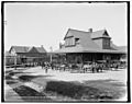
Mount Pocono Station (1886, demolished 1937), c. 1905.
-
Montanesca Hotel (1901, burned 1911).
-
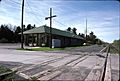
Pocono Summit Station, in 1988.
-
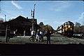
Mount Pocono Station, in 1991.
-
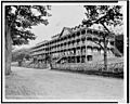
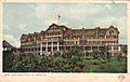
Pocono Mountain House in 1905.


See also
 In Spanish: Mount Pocono para niños
