Mount Queets facts for kids
Quick facts for kids Mount Queets |
|
|---|---|
 |
|
| Highest point | |
| Elevation | 6,476 ft (1,974 m) |
| Prominence | 516 ft (157 m) |
| Geography | |
| Location | Olympic National Park Jefferson County, Washington, United States |
| Parent range | Olympic Mountains |
| Topo map | USGS Mount Queets |
| Geology | |
| Age of rock | Eocene |
| Type of rock | basalt |
| Climbing | |
| First ascent | 1890 Harry Fisher (aka James B. Hanmore), Nelson Linsley |
| Easiest route | Scrambling YDS 2 via North Ridge |
Mount Queets is a tall mountain, about 6,476-foot (1,974-metre) (1,974 meters) high. It's found deep inside Olympic National Park in Jefferson County, Washington state. If the weather is clear, you can even see its top from the visitor center at Hurricane Ridge.
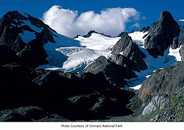
Its neighbor, Mount Meany, is a bit taller at 6,695 feet (2,041 meters). It's only about 0.8 mi (1.3 km) south of Mount Queets. Even though it's not the tallest mountain, Mount Queets gets a lot of snow in winter. This snow forms the Queets Glacier on its northern side, nestled in a bowl-shaped area called a cirque. Water from the mountain flows into the beginnings of both the Elwha River and Queets River.
People who like to climb can find different ways to reach the top. Some routes are easier, like "scrambling" (a mix of walking and easy climbing) up the North Ridge. Other routes are more challenging, especially those involving the Queets Glacier.
Mountain's Name and History
The area around Mount Queets and Mount Meany was once called Mount Mesachie. This name appeared on an old map from 1896. The word mesachie comes from an old trading language called Chinook Jargon, and it means wicked or bad.
Later, during an exploration trip in 1889-1890, the mountain was named "Mt. Hearst." This was done to honor William Randolph Hearst, who owned a newspaper called the San Francisco Examiner. However, today the official name is Mount Queets.
The name "Queets" first appeared on a map of Washington Territory. It referred to the Queets River. Later, it was used for the glacier on the mountain, which is where the river starts. The word "Queets" comes from the name of the Quai'tso (Queets) tribe, who lived in the area.
The first time anyone climbed to the top of Mount Queets was in 1890. This was done by Harry Fisher (also known as James B. Hanmore) and Nelson Linsley. They were part of an exploration group called the O’Neil Expedition.
Weather and Climate
Mount Queets is in a place with a "marine west coast" climate. This means it's near the ocean and gets a lot of rain and snow. Most of the weather systems come from the Pacific Ocean and move towards the Olympic Mountains.
When these weather systems hit the tall Olympic peaks, they are forced to rise. As they go higher, they drop their moisture as rain or snow. This is why the Olympic Mountains get so much precipitation, especially in winter.
During winter, the weather is usually cloudy. But in the summer, high-pressure systems over the Pacific Ocean often bring clear skies. The best months for climbing Mount Queets are usually from June through September, when the weather is nicer.
 | Janet Taylor Pickett |
 | Synthia Saint James |
 | Howardena Pindell |
 | Faith Ringgold |


