
Mount Roraima National Park facts for kids
Quick facts for kids Mount Roraima National Park |
|
|---|---|
| Parque Nacional do Monte Roraima | |
|
IUCN Category II (National Park)
|
|

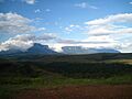
Skyline from the top of Mount Roraima
|
|

Mount Roraima National Park
Location in Brazil
|
|
| Nearest city | Boa Vista, Roraima |
| Area | 116,747.80 hectares (288,490.1 acres) |
| Designation | National park |
| Created | 28 June 1989 |
| Administrator | Chico Mendes Institute for Biodiversity Conservation |
Mount Roraima National Park (Portuguese: Parque Nacional do Monte Roraima) is a special national park located in the state of Roraima, in northern Brazil. It was created to protect a unique part of nature.
This park includes the Brazilian side of Mount Roraima, which is a famous flat-topped mountain. It also covers other mountains along the borders with Venezuela and Guyana. Inside the park, you can find different types of environments, like dense tropical rainforests and open savannas.
The entire park is located within the Raposa Serra do Sol indigenous territory. This means the park has two important jobs: to protect the environment and to support the rights of the indigenous people who live there.
Contents
Exploring Mount Roraima National Park
Mount Roraima National Park is found in the Uiramutã area of Roraima state. It covers a large area of about 116,747.80 hectares (288,490.1 acres), which is like protecting many football fields!
The park is named after Mount Roraima, which is the highest of the Tepui mountains. These are ancient, flat-topped mountains that look like giant tables. Mount Roraima stands almost 3,000 metres (9,800 ft) tall. At its flat top, there's a special monument called the Marco da Triplice Fronteira. This is where the borders of Venezuela, Guyana, and Brazil all meet. Imagine standing in three countries at once!
The land inside the park goes from about 920 metres (3,020 ft) up to 2,780 metres (9,120 ft) above sea level. The mountains here often have huge, flat tops with very steep cliffs around them. These cliffs are surrounded by lower areas with deep valleys and ravines.
The park is also home to the sources of some important rivers that flow south into the Branco River. These include the Cotingo River, which starts near Mount Roraima, and the Ireng River (also called Maú), which forms part of the border between Brazil and Guyana. These rivers have many rapids and beautiful waterfalls, like the amazing Garã Garã waterfall on the Maú River.
The park is also home to indigenous people who have lived there for a long time. There have been discussions about how to best use the land, balancing nature protection with the needs of the local communities.
Nature and Wildlife
Mount Roraima National Park is part of the Amazon biome, which is one of the most biodiverse places on Earth. Even though the park is not huge, its different landscapes help protect many kinds of plants and animals.
The temperatures in the park can range from 2 to 18 °C (36 to 64 °F), with an average of about 10 °C (50 °F). The park gets a lot of rain, about 1,900 millimetres (75 in) each year.
About 8.7% of the park is covered by savanna, which is a type of grassland with scattered trees. The rest of the park has different kinds of forests. Some parts have dense forests with very tall trees, while other areas have forests with a closed roof of leaves on the slopes.
Many unique species of plants and animals live here. They have adapted to the tough mountain climate, where temperatures can change a lot in just one day, sometimes from 4 to 25 °C (39 to 77 °F)!
How the Park Was Created

Mount Roraima National Park was officially created on June 28, 1989. It is managed by the Chico Mendes Institute for Biodiversity Conservation (ICMBio), which is a Brazilian government agency that protects nature.
The main goals of the park are to:
- Protect its beautiful natural ecosystems and amazing scenery.
- Allow for scientific research to learn more about the area.
- Provide environmental education so people can learn about nature.
- Offer opportunities for recreation and tourism that respect the environment.
Early on, other countries in the Amazon region suggested connecting Mount Roraima National Park with Venezuela's Canaima National Park. This would create a huge protected area across borders, making it easier to manage tourism, research, and conservation together.
For a while, the park mostly existed "on paper" because there wasn't enough money to fully set it up. In 2001, the United Nations provided funds to help Brazil create and manage its parks.
When the park started to be set up, there were some concerns from the local Ingarikó and Macushi people. These indigenous groups had used the land for hunting, farming, and religious practices for many years. The government worked with the indigenous communities to find a way for them to continue their traditions while also protecting the park's environment.
In 2005, a special agreement was made. The area became part of the Raposa Serra do Sol Indigenous Territory. This means Mount Roraima National Park now has a dual role: it protects nature and also ensures the constitutional rights of the indigenous people living there.
Images for kids
-
Plateau and mountains in the park
See also
 In Spanish: Parque nacional del Monte Roraima para niños
