
Mount Ross facts for kids
Quick facts for kids Mount Ross |
|
|---|---|

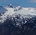
Mount Ross seen from Diablo Lake Overlook
|
|
| Highest point | |
| Elevation | 6,052 ft (1,845 m) |
| Prominence | 452 ft (138 m) |
| Geography | |

Mount Ross
Location in Washington (state)

Mount Ross
Location in the United States
|
|
| Parent range | North Cascades |
| Topo map | USGS Diablo Dam |
| Climbing | |
| First ascent | August 17, 1969 by Jack Roper, Maurine Roper, Jan Bergerson |
| Easiest route | Scramble |

Mount Ross is a mountain peak that stands 6,052 feet (about 1,845 meters) tall in the North Cascades mountain range. It is located in Washington, United States. This mountain is part of the beautiful North Cascades National Park and the Stephen Mather Wilderness, which are protected natural areas.
Mount Ross rises sharply from the North Cascades Highway and the town of Newhalem, Washington, which are both at its southern base. Even though it's not the tallest mountain around, it's very noticeable because it rises so steeply from the land around it. The mountain is named after James Delmage Ross (1872–1939). He was in charge of the Skagit River Hydroelectric Project, which built dams to make electricity. Ross Dam and Ross Lake are also named after him.
The first people to climb Mount Ross were Jack Roper, Maurine Roper, and Jan Bergerson on August 17, 1969. The closest mountain that is taller than Mount Ross is The Roost, which is about 1.09 miles (1.75 kilometers) to the north. All the rain and snow that falls on Mount Ross eventually flows into the Skagit River.
What's the Weather Like on Mount Ross?
Mount Ross is in a "marine west coast" climate zone. This means it's near the ocean, so the weather is often mild and wet. Most of the weather systems that bring rain and snow start over the Pacific Ocean. They then travel northeast towards the Cascade Mountains.
When these weather systems hit the tall peaks of the North Cascades, the air is forced to rise. As it goes higher, it cools down and drops its moisture as rain or snow. This process is called "orographic lift." Because of this, the western side of the North Cascades gets a lot of rain and snow, especially in winter.
During the winter, it's usually cloudy. But in the summer, high-pressure systems over the Pacific Ocean often bring clear skies. Because the weather is influenced by the ocean, the snow tends to be wet and heavy. This can create a high risk of avalanches, which are large slides of snow down the mountain.
How Was Mount Ross Formed?
The North Cascades mountains have very rugged and dramatic landscapes. You can see jagged peaks, long ridges, and deep valleys carved by glaciers. The way the land looks today was created by huge geological events that happened millions of years ago. These events caused big changes in elevation and led to different climates and types of plants in the area.
The Cascade Mountains started forming millions of years ago, during a time called the late Eocene Epoch. This happened because the North American Plate (a huge piece of Earth's crust) was slowly moving over the Pacific Plate. This movement caused a lot of volcanic activity, creating many volcanoes.
Also, smaller pieces of Earth's crust, called terranes, joined together to form the North Cascades about 50 million years ago.
During the Pleistocene period, which was over two million years ago, huge sheets of ice called glaciers moved across the land many times. As they moved, they carved out the landscape, leaving behind rock debris. The river valleys in this area have a "U" shape, which is a clear sign that glaciers once moved through them. The combination of the land being pushed up (uplift), cracks forming in the Earth (faulting), and glaciers carving the land has created the tall peaks and deep valleys you see in the North Cascades today.
- Weather: Mount Ross
Images for kids
-
Mt. Ross (centered) and Mt. Triumph (behind, left), seen from Ruby Mountain
-

J.D. Ross, 1930


