
Naches Peak facts for kids
Quick facts for kids Naches Peak |
|
|---|---|

Naches Peak seen from Highway 410
|
|
| Highest point | |
| Elevation | 6,452 ft (1,967 m) |
| Prominence | 692 ft (211 m) |
| Isolation | 1.45 mi (2.33 km) |
| Parent peak | Tahtlum Peak (6,567 ft) |
| Geography | |

Naches Peak
Location in Washington (state)

Naches Peak
Location in the United States
|
|
| Location | Mount Rainier National Park Pierce County, Washington, U.S. |
| Parent range | Cascades |
| Topo map | USGS Chinook Pass |
| Climbing | |
| Easiest route | Scrambling class 4 |
Naches Peak is a mountain in Washington state. It stands 6,452 feet (1,967 meters) tall. This peak is special because it sits right on the border of Mount Rainier National Park and the William O. Douglas Wilderness. It also marks the line between Pierce County and Yakima County.
Naches Peak is part of the Cascade Range, a long chain of mountains. It's located just southeast of a mountain pass called Chinook Pass. The closest taller mountain is Tahtlum Peak, about 1.45 miles (2.33 km) to the east. The name Naches Peak was suggested by the Yakima Chamber of Commerce and approved in 1927.
A very popular trail called the Naches Peak Loop Trail goes all the way around the peak. It's about 3.5 miles long. Water from the west side of Naches Peak flows into Chinook Creek, which then joins the Ohanapecosh River. Water from the east side flows into smaller streams that feed the American River.
Contents
Weather and Climate at Naches Peak
Naches Peak is in a "marine west coast" climate zone. This means it gets a lot of moisture from the Pacific Ocean. Most of the weather systems, like big clouds and storms, start over the Pacific. They then travel northeast towards the Cascade Mountains.
How Mountains Affect Weather
When these weather systems reach the tall Cascade Mountains, they are forced to rise. As the air goes higher, it cools down. This cooling causes the moisture in the air to turn into rain or snow. This process is called Orographic lift. Because of this, the western side of the Cascades gets a lot of rain and snow, especially in winter.
Winter and Summer Weather
The snow here tends to be wet and heavy. This can sometimes lead to a high risk of avalanches, which are large slides of snow down a mountain. During winter, the weather is often cloudy. However, in summer, high-pressure systems over the Pacific Ocean usually bring clear skies. The best time to visit Naches Peak for hiking or enjoying the views is from July to September.
Images for kids
-
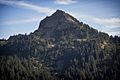
Naches Peak from north
-
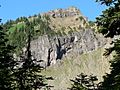
West side of Naches Peak
-
East side of Naches Peak
-
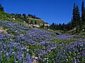
Beautiful lupine wildflowers along the loop trail
-
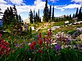
Indian paintbrush flowers along the loop trail
-
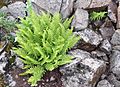
A fern growing along the loop trail
-
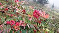
A Sitka Mountain-ash tree

.JPG)

.jpg)
.jpeg)
_(7993253369).jpg)
_(7967518190).jpg)
