Nance County, Nebraska facts for kids
Quick facts for kids
Nance County
|
|
|---|---|

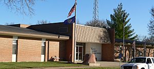
Nance County courthouse in Fullerton
|
|

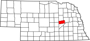
Location within the U.S. state of Nebraska
|
|
 Nebraska's location within the U.S. |
|
| Country | |
| State | |
| Founded | 1879 |
| Named for | Albinus Nance |
| Seat | Fullerton |
| Largest city | Fullerton |
| Area | |
| • Total | 448 sq mi (1,160 km2) |
| • Land | 442 sq mi (1,140 km2) |
| • Water | 6.6 sq mi (17 km2) 1.50%% |
| Population
(2020)
|
|
| • Total | 3,380 |
| • Density | 7.545/sq mi (2.913/km2) |
| Time zone | UTC−6 (Central) |
| • Summer (DST) | UTC−5 (CDT) |
| Congressional district | 3rd |
Nance County is a county located in the state of Nebraska in the United States. It's like a smaller region within the state. In 2020, about 3,380 people lived there. The main town and county seat (where the county government is) is Fullerton.
If you see a Nebraska license plate, Nance County is shown by the number 58. This is because it had the fifty-eighth largest number of vehicles registered in the county back in 1922 when the license plate system started.
Contents
History of Nance County
The land that is now Nance County was once a special area called the Pawnee Reservation. This reservation was created in 1857 after the Pawnee Native American tribe signed an agreement with the United States. They gave up their lands in exchange for this reservation.
After Nebraska became a state in 1867, the state government took over the land. They sold it and used the money to help the Pawnee people get new lands elsewhere. By the mid-1870s, the rest of the reservation was sold. In 1876, the Pawnee tribe moved to their current home in central Oklahoma.
The official borders for Nance County were set in 1879. The county was named after Governor Albinus Nance, who was a important leader at that time.
Most of the land in Nance County was bought by people who wanted to settle there or by investors who planned to sell it later. This was different from other parts of Nebraska, where people often got land through the Homestead Act. The Homestead Act allowed settlers to claim land if they lived on it and improved it.
Geography of Nance County
Nance County has rolling hills that gently slope towards the northeast. The Loup River flows through the middle of the county, moving from west to east. Another river, the Cedar River, flows southeast and joins the Loup River near the town of Fullerton.
The county covers a total area of about 448 square miles. Most of this area, about 442 square miles, is land. The remaining 6.6 square miles is water, which makes up about 1.5% of the county's total area.
Main Roads
These are the most important highways that run through Nance County:
Neighboring Counties
Nance County shares its borders with these other counties:
- Platte County to the northeast
- Merrick County to the south
- Greeley County to the west
- Boone County to the north
Population of Nance County
| Historical population | |||
|---|---|---|---|
| Census | Pop. | %± | |
| 1870 | 44 | — | |
| 1880 | 1,212 | 2,654.5% | |
| 1890 | 5,773 | 376.3% | |
| 1900 | 8,222 | 42.4% | |
| 1910 | 8,926 | 8.6% | |
| 1920 | 8,712 | −2.4% | |
| 1930 | 8,718 | 0.1% | |
| 1940 | 7,653 | −12.2% | |
| 1950 | 6,512 | −14.9% | |
| 1960 | 5,635 | −13.5% | |
| 1970 | 5,142 | −8.7% | |
| 1980 | 4,740 | −7.8% | |
| 1990 | 4,275 | −9.8% | |
| 2000 | 4,038 | −5.5% | |
| 2010 | 3,735 | −7.5% | |
| 2020 | 3,380 | −9.5% | |
| 2021 (est.) | 3,390 | −9.2% | |
| US Decennial Census 1790-1960 1900-1990 1990-2000 2010 |
|||
According to the 2000 United States Census, there were 4,038 people living in Nance County. These people lived in 1,577 households, and 1,107 of these were families.
About 32.8% of the households had children under 18 living with them. Most households, 60.5%, were married couples living together. About 27.6% of all households were made up of people living alone.
The population of the county included many different age groups. About 27.9% of the people were under 18 years old. About 19.7% were 65 years old or older. The average age in the county was 40 years.
Towns and Villages
Nance County has several communities, including cities, a village, and smaller unincorporated areas.
Cities
Village
Unincorporated Communities
These are smaller places that are not officially organized as cities or villages:
Townships
Townships are smaller divisions within the county, often used for local government or land organization:
- Beaver
- Cedar
- Cottonwood
- Council Creek
- East Newman
- Fullerton
- Genoa
- Loup Ferry
- Prairie Creek
- South Branch
- Timber Creek
- West Newman
See also
 In Spanish: Condado de Nance para niños

