
Napaleofú facts for kids
Quick facts for kids
Napaleofú
|
|
|---|---|
|
Town
|
|
 |
|
| Country | Argentina |
| Province | Buenos Aires |
| Partidos | Barcarce and Lobería |
| Elevation | 159 m (522 ft) |
| Population | |
| • Total | 374 inhabitants |
| Source: 2010 INDEC National Census. | |
| Time zone | UTC−3 (ART) |
| Postal code |
7007
|
| Area code(s) | 02266 |
Napaleofú is a small town located in the southeast part of the Buenos Aires province in Argentina. It's about 50 km from Tandil and 63 km from Balcarce. The town is mostly managed by the Balcarce Partido (a type of local government area), but some of its land is part of the Lobería Partido. The name "Napaleofú" comes from the Mapuche language. It likely means "stream" or "river," referring to what is now called Arroyo Chico.
The town started with people called "emphyteutas." These were settlers who leased large areas of land from the government. They built big farms called estancias, feeling safer because of the nearby Fuerte Independencia (a fort). Mr. Manuel Sánchez received a large piece of land and started the Estancia Napaleofú. After he passed away, his family gave land for the town and the railroad station to be built. For a long time, the streets didn't have names because everyone knew each other. But in 1994, names were finally given to help with mail and other services.
Napaleofú's economy mainly relies on farming and raising animals. There's also some mining and small-scale production of things like bread and pastries. A unique challenge for the town is that it belongs to two different local government areas (and sometimes even three!). This can cause funny situations, like a school having classrooms in two different areas. The town has schools for all ages: a kindergarten, a primary school, and a secondary school.
Contents
Where is Napaleofú?
Napaleofú is located 50 km from Tandil, 62 km from Balcarce, and 63 km from Lobería. The town's main area is controlled by the Balcarce Partido. However, most of the surrounding rural land is part of the Lobería Partido. Some nearby fields even fall under the Tandil Partido, making it a unique "tripartite" (three-part) area.
The Land Around Napaleofú
The town is in a flat, agricultural area. It's close to the sea in the east and the Tandilia mountain range in the west. The land is gently sloped and made of fine soil called loess. Sometimes, there's a hard, rocky layer called "tosca" not far below the surface. When this layer is present, it can make farming harder.
Napaleofú's Weather
The climate here is like an oceanic climate, meaning it gets a good amount of rain. On average, about 800 mm of rain falls each year. The most rain happens in January, February, and March, while June, July, and August are the driest months. The average yearly temperature is around 13.3º Celsius. The period from October to early March usually doesn't have any frost.
Plants in the Area
Not much of the original plant life remains in this region. This is because people have used the land a lot for farming and other activities. The natural plants would have been grass steppes, which are grasslands less than a meter tall.
What Does Napaleofú Mean?
The name Napaleofú comes from the Mapuche language. The part "-leofú" means "stream" or "river." It's believed that the native people used this name for the small river that is now called Arroyo Chico.
A Look at Napaleofú's Past
The First People

The first people living in these lands were called serranos. They were a group related to the Tehuelche people. They hunted guanacos and used stones from the mountains to make tools and weapons. You can still find archaeological remains of their workshops in places like the Cueva del Indio.
After the Spanish arrived and brought cattle, these native groups started trading "cimarrón" cattle. These were wild cattle that grew in numbers on the large grasslands. The Indios Serranos (Highlands indigenous people) traded with the Spanish settlers. Sometimes, they would also raid farms to take cattle.
In the 1800s, the Argentine government launched military expeditions against the native peoples, known as the Desert Campaign. This led to the disappearance of many native groups. However, signs of their presence remain in Napaleofú. For example, there are old corrals (animal pens) built with stacked stones, some two meters high and a hundred meters long. These corrals were used for shelter and to keep livestock before selling them.
Early Settlers and Farms
Around 1825, after military campaigns, the government of Buenos Aires Province gained control of these lands. They were then leased out in large sections for 20 or 30 years because they couldn't be sold. The people who leased these lands were called emphyteuta.
In 1826, Manuel Sánchez was granted a large piece of land near the Arroyo Napaleofú (then called "Arroyo Chico"). This became the "Estancia Napaleofú," the oldest farm in the area. Other settlers also started farms nearby. The Fuerte Independencia fort in Tandil offered some protection from attacks by native groups.
The first settlers came from the north, and later, Europeans arrived. Even after the native population was mostly subdued, raids continued for many years. There are also stories about "vagos" (vagrants) and "malentretenidos" (troublemakers) who hid in caves. During those times, there were "pulperías" (general stores and taverns) that also served as safe places for travelers during possible attacks.
How the Town Began
The town of Napaleofú grew from these early farms. But the town itself truly began with the arrival of the Southern Railroad, later known as the General Roca. In 1914, the railway reached Napaleofú. For 15 years, it was the end of the line, making Napaleofú a central hub for farming and trade in the region.
The Napaleofú Station was built on land donated by the Cuevas family. It opened on December 16, 1914. There was a plan to name the station "Miguel Cuevas" after the family who donated the land, but it didn't happen.
Also in 1914, the first store, El Cantábrico, opened. It was originally called La Fundadora. This store was very important. It sold goods, served drinks, and even had a small hotel, a hairdresser, and later a social club. A general store, a sawmill, an animal loading dock, and some houses were built around the station. By 1929, Napaleofú had about one hundred people, mostly involved in farming and raising animals. Many of today's residents are descendants of immigrants from Spain, France (Basque region), and Italy who arrived in the early 1900s. In the 1940s, Argentine immigrants, especially from Santiago del Estero, also settled here to work in potato harvesting.
In 1946, National Route 226 was opened, passing 5 km from the town. Later, National Route 227 was built, connecting Route 226 with Quequén. This new road helped the town grow, and new buildings like the Municipal Delegation, the church, and the kindergarten were constructed.
Streets and Their Names
For a long time, the streets of Napaleofú didn't have names. Everyone knew each other, so it wasn't a problem for locals. However, it caused issues for postal services and other companies trying to deliver mail or bills.
In 1994, students from a local school suggested a project to name the streets. The Balcarce Deliberating Council approved it. They decided to honor the town's roots by using names from the Mapuche language.
So, the street at the town's entrance is called "Conque" (meaning entrance). The one at the exit is "Tuun" (meaning to leave). The street by the main square is "Ranguiche" (in the middle of the crowd). Other names include "Putupeyel" (drink) for the bar street, "Palihue" (field) for the soccer field street, "Lovhuen" (headquarters) for the police station street, "Huelucau" (commerce) for the store street, "Quimelcan" (to instruct) for the middle school street, and "Quiteu" (gardener) for the kindergarten street. Some names like "Cunapán" (to come here) or "Nguepal" (to pass through) don't point to a specific place.
Some residents didn't like the idea of naming the streets. Even years later, they still call "Conque" "the street at the entrance" because the Mapuche names are hard for them to say.
A resident named Elsa Guillermo told a newspaper:
In Napaleofú there were no problems, because we all knew each other. The problem is outside, when it is time to do paperwork. For example, many people in the cities find it hard to understand that we live on a street without a number, because they have to fill in boxes with forms. And if they write down the name of the street, they write it in any way they can.
—Elsa Guillermo, a young woman from the town interviewed by La Nación newspaper
Belonging to Different Areas
When the town was divided between Lobería and Balcarce in 1914, some interesting problems came up. For example, vehicle owners used to have to pay taxes to both Lobería and Balcarce to drive on their streets. Some people even registered their legal address in Lobería to get their driving licenses faster than in Balcarce.
Another example is that many people are registered in Tandil, where they have to go to vote. Also, students attending university courses often go to the National University of Central Buenos Aires in Tandil.
The consequences of belonging to different partidos can be quite curious. The soccer field of the Club Defensores belongs to Lobería. But the changing rooms are across the street "Devupulen" (which is the border between the two partidos) and therefore belong to Balcarce! The same thing happens with School Nº26: some classrooms are in Balcarce and others are in Lobería. Also, the streets have to be repaired by the local government area they belong to.
Population of Napaleofú
According to the 2010 census, Napaleofú has 374 inhabitants. This is a small decrease from the 377 inhabitants counted in the 2001 census.
| Vertical bar chart of demographic evolution of Napaleofú between 1991 and 2010 |
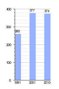 |
| Source: INDEC National Census. |
However, some unofficial surveys in 2008 suggested the population might be over a thousand people.
Most residents regularly go to the "Defensores" club, where many dances and parties are held. They also enjoy the "El Fogón" social group.
Local people have helped the community by donating money to paint the chapel, fix up the police station, and buy a patrol car and night vision goggles for the police to help fight crime in rural areas.
A group of neighbors also grows soybeans on land owned by the railroad. They do this to raise money for local groups. Soybeans are chosen because they are cheaper to grow and make more profit. Other crops like wheat can catch fire easily, and sunflowers are eaten by parrots. If they planted corn, the local people would eat it themselves! The railroad company gave them ten hectares of land for this project. A local farmer planted and harvested the soybeans, and the money earned went to the club, schools, the retirement center, and other local organizations.
Napaleofú's Economy
Farming in Napaleofú is varied. Farmers grow different crops depending on the land, soil, and market prices. They practice crop rotation, meaning they change what they plant each season. This includes winter or spring wheat, oats for grazing animals, corn for grain or animal feed, sunflower, and potatoes. This area is not just focused on growing soybeans. There are silos in the area to store summer crops. This helps farmers have food for animals in winter or to sell later, which increases how much they earn from each hectare. Farmers also use chemicals to control weeds and pests, and they use manure and fertilizers to help crops grow.
Regarding raising animals, farmers raise cows for milk or for beef. Most of the beef is sold in the Liniers Market or to cool stores. Raising sheep has become less common and is mostly done for families to eat. Dairy farms here range from large ones with modern technology to smaller ones. All of them have strict quality checks by Argentina's main dairy companies.
There are also farms that specialize in raising cattle for breeding. They sell these animals at rural fairs and shows.
In recent years, there has been a lot of tree planting. This has changed the typical treeless grassland landscape of the Pampas. Eucalyptus and acacia trees have been planted. This has also helped get rid of the tall grasses that made it hard to herd cattle.
There was also some mining activity. Stones were taken from the area to build breakwaters (walls to protect coasts) in Necochea and Quequén.
The town also produces some manufactured goods from farm products. This includes bread, pasta, pastries, sausages, cheese, and sweets. There are also workshops for artistic blacksmithing, ironwork, and lathe work.
Education in Napaleofú
Napaleofú has three schools, all managed by the Lobería School Board. These are a kindergarten, an elementary school, and a high school. Work is also being done to bring natural gas to the area.
Club Defensores de Napaleofú

This club started in 1922 as the Club Defensores de Napaleofú. It was closed for a few years between 1925 and 1927. In 1930, it reopened with a new committee led by Eduardo Varela.
Today, the main sport at the club is football (soccer). But the club also hosts many social and cultural events. These activities take place in the main building, which was built in 1960, replacing an older one made of sheet metal. In 1984, a room for meetings or small gatherings was added.
In soccer, the club is part of the "Liga Agraria Amateur." In its early days, until 1969, it was part of the "Liga Regional Agraria." Until 1979, it was a member of the "Liga Tandilense" and even won the championship in its first year! The club's money comes from selling raffle tickets, donations, and a percentage of ticket sales from the league games.
Images for kids
-
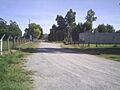
A street in Napaleofú.
See also
 In Spanish: Napaleofú para niños
