
National Register of Historic Places listings in Goshen County, Wyoming facts for kids

Have you ever wondered about old buildings and places that are super important to history? In Goshen County, Wyoming, there are several amazing spots listed on the National Register of Historic Places. This special list helps protect places that tell us stories about the past. It's like a hall of fame for historic sites!
These places are recognized because they are important to the history of the United States, Wyoming, or even just Goshen County. They could be old forts, trails, buildings, or even ancient campsites. Let's explore some of these cool historical treasures in Goshen County!
Contents
Historic Places in Goshen County
Goshen County is home to seven special places on the National Register of Historic Places. Each one has a unique story to tell.
Cheyenne-Black Hills Stage Route
- Name: Cheyenne-Black Hills Stage Route and Rawhide Buttes and Running Water Stage Stations
- Location: Near Lusk
- Listed: April 16, 1969
- Image:

This historic route was a very important trail in the old West. It was used by stagecoaches carrying people, mail, and goods between Cheyenne and the Black Hills. Imagine bumpy rides and exciting adventures! Along this route, there were "stage stations" where travelers could rest, change horses, and grab a meal. These stations were like rest stops for the stagecoaches.
Fort Laramie National Historic Site
- Name: Fort Laramie National Historic Site
- Location: Southwest of Fort Laramie
- Listed: October 15, 1966
- Image:

Fort Laramie National Historic Site is one of the most famous historic places in Wyoming. It started as a fur trading post in the 1830s. Later, it became a very important military fort. It helped protect travelers on the Oregon Trail, Mormon Trail, and California Trail. Many important treaties with Native American tribes were also signed here. Walking around Fort Laramie today feels like stepping back in time!
Fort Laramie Three-Mile Hog Ranch
- Name: Fort Laramie Three-Mile Hog Ranch
- Location: West of Fort Laramie along the Laramie River
- Listed: April 23, 1975
This site was once a busy place located just a few miles from Fort Laramie. It was a private business that served the soldiers and other people connected to the fort. It provided various services and entertainment for those living and working in the area during the frontier days.
Hell Gap Paleoindian Site
- Name: Hell Gap Paleoindian Site (48GO305)
- Location: Near Guernsey
- Listed: December 23, 2016
The Hell Gap Paleoindian Site is an amazing archaeological site. It shows evidence of very early human life in North America. Scientists have found tools and other artifacts here that are thousands of years old! This site helps us understand how ancient people lived, hunted, and survived in Wyoming a very long time ago. It's like a giant puzzle that helps us learn about the first Americans.
Jay Em Historic District
- Name: Jay Em Historic District
- Location: Main Street, Jay Em
- Listed: April 12, 1984
- Image:

The Jay Em Historic District includes several old buildings that make up the heart of the small town of Jay Em. This district shows what a typical small ranching community looked like in Wyoming many years ago. It gives us a glimpse into the daily life and architecture of a historic frontier town.
South Torrington Union Pacific Depot
- Name: South Torrington Union Pacific Depot
- Location: U.S. Route 85, Torrington
- Listed: December 31, 1974
- Image:

This old train station, or "depot," in Torrington was once a very busy place. It was part of the Union Pacific Railroad system. Train depots were important hubs for travel and trade. People would arrive and depart from here, and goods would be shipped in and out of the area. It played a big role in connecting Torrington to the rest of the country.
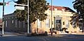
US Post Office-Torrington Main
- Name: US Post Office-Torrington Main
- Location: 2145 Main Street, Torrington
- Listed: May 19, 1987
- Image:

The main post office building in Torrington is also on the National Register. Post offices are often important community buildings. They serve as central places for sending and receiving mail, which was especially vital before the internet and phones. This building's design and history reflect the importance of postal services in the community.
Images for kids
-
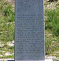
A historical marker for the Cheyenne-Black Hills Trail.
-
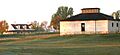
The historic grounds of Fort Laramie.
-
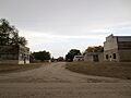
A view of the historic buildings in Jay Em.
-
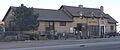
The historic South Torrington Union Pacific Depot.
-
The main post office building in Torrington.
