
National Register of Historic Places listings in Kenai Peninsula Borough, Alaska facts for kids

Imagine a special list that helps protect important old buildings, places, and even parts of nature! That's what the National Register of Historic Places is. It's like a hall of fame for places that tell us about America's past. In the Kenai Peninsula Borough in Alaska, there are 36 amazing spots on this list. These places include old churches, historic homes, important archaeological sites, and even a railroad tunnel! Two of these places are extra special and are called National Historic Landmarks.
This article will tell you about some of these fascinating historic places in the Kenai Peninsula Borough. They help us learn about the rich history of this part of Alaska, from its early Native cultures to the gold rush days and the growth of towns.
Contents
What is the National Register of Historic Places?
The National Register of Historic Places is the official list of the nation's historic places worth saving. It's managed by the National Park Service in the United States. When a place is added to this list, it means it's recognized for its importance in American history, architecture, archaeology, engineering, or culture.
Why are places listed?
Places are listed for many reasons. Some might be very old, showing us how people lived long ago. Others might be linked to important events or famous people. Some are great examples of a certain type of building or design. Being on the list helps protect these places and often makes them eligible for special grants or tax breaks to help with their care.
National Historic Landmarks
Among the many places on the National Register, some are even more important. These are called National Historic Landmarks (NHLs). They are places that have exceptional national historical significance. The Kenai Peninsula Borough is home to two of these very special landmarks.
Historic Places in Kenai Peninsula Borough
The Kenai Peninsula has a diverse history, and its listed places reflect that. You'll find sites related to early Native Alaskan life, Russian influence, gold mining, and the development of towns and transportation.
Early History and Native Culture
Some of the oldest sites on the list tell us about the people who lived in Alaska long before modern towns were built.
Chugachik Island Site
Near Homer, the Chugachik Island Site is an archaeological spot. It helps experts learn about the ancient cultures that lived on these islands and coasts.
Coal Village Site
North of Port Graham, the Coal Village Site is another important archaeological area. It gives clues about early communities and their way of life in this region.
Selenie Lagoon Archeological Site
Also near Port Graham, the Selenie Lagoon Archeological Site is a place where scientists study the remains of past human activity. These sites are like giant puzzles that help us understand history.
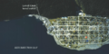
Yukon Island Main Site
One of the two National Historic Landmarks in the borough is the Yukon Island Main Site, located about 9 miles south of Homer. This site is incredibly important for understanding the history of early human settlements in the Gulf of Alaska. It shows evidence of people living there thousands of years ago.
Russian Heritage
Alaska has a strong connection to Russia, as it was once a Russian colony. This history is preserved in several places on the Kenai Peninsula.
Church of the Assumption of the Virgin Mary
In Kenai, you'll find the Church of the Assumption of the Virgin Mary. This beautiful church is a National Historic Landmark. It was built in 1895 and is a wonderful example of Russian Orthodox church architecture in Alaska. It shows the lasting influence of Russian culture in the area.
Holy Transfiguration of Our Lord Chapel
Located in Ninilchik, this chapel is another historic Russian Orthodox church. It was built in 1901 and stands as a symbol of the strong Russian heritage in the community.
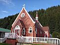
St. Nicholas Chapel
In Seldovia, the St. Nicholas Chapel is a historic Russian Orthodox church that was built in 1891. It's a key part of the town's history and religious life.
Sts. Sergius and Herman of Valaam Church
This Russian Orthodox church, built in 1930, is located in Nanwalek. It's another example of the enduring Russian influence in the region's spiritual and architectural landscape.
Gold Rush and Early Settlements
The discovery of gold brought many people to Alaska, leading to the growth of new towns and industries.
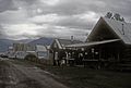
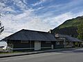
Hope Historic District
The town of Hope has a historic district that includes many buildings from its gold rush days. It's like stepping back in time to when miners flocked to the area looking for riches.
Sunrise City Historic District
East of Hope, at the mouth of Sixmile Creek, is the Sunrise City Historic District. This was once a bustling gold mining town, and its remains tell the story of that exciting era.
Hirshey Mine
Southeast of Hope, the Hirshey Mine is a reminder of the mining operations that shaped the region's economy and settlement patterns.
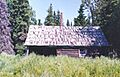
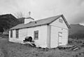
Andrew Berg Cabin
About 30 miles southeast of Soldotna, the Andrew Berg Cabin is a historic log cabin. It represents the life of early settlers and homesteaders who came to Alaska.
Victor Holm Cabin and Homestead
Southwest of Kenai, near the Kasilof River, you'll find the Victor Holm Cabin, built in 1890. This cabin and the larger Victor Holm Homestead property show what life was like for pioneering homesteaders in the late 1800s.
Seward's Historic Buildings and Structures
Seward is a city with a rich history, especially as a port and a starting point for the Alaska Railroad. Many of its buildings are on the National Register.
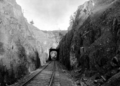
Alaska Central Railroad Tunnel No. 1
North of Seward, this tunnel is a part of the early efforts to build a railroad through Alaska's challenging terrain. It's a testament to the engineering feats of the past.
Ballaine House
Located on 3rd Avenue, the Ballaine House is a historic home in Seward. It's an example of the early residential architecture in the city.
Brown & Hawkins Store
This historic store on 4th Avenue in Seward was a key business in the early days of the town. It shows how commerce developed in the region.
Diversion Tunnel (Lowell Creek)
At Lowell Creek in Seward, this tunnel was built by the U.S. Army Corps of Engineers to divert the creek. It's an important piece of infrastructure that helped protect the town from floods.
Government Cable Office
On 6th Avenue, the Government Cable Office played a vital role in communication for Seward and beyond. It was part of the telegraph and cable network that connected Alaska to the rest of the world.
Hoben Park
Hoben Park on Railway Avenue is a historic park in Seward. It's a place where the community has gathered for many years.
Jesse Lee Home for Children
This historic home on Swetmann Avenue in Seward provided care and education for children in Alaska for many years. It has a significant place in the social history of the region.
Seward Depot
The Seward Depot on Railway Avenue was the main train station for the Alaska Railroad. It was a bustling hub for travelers and goods, connecting Seward to the interior of Alaska.
St. Peter's Episcopal Church
At 2nd Avenue and Adams Street, St. Peter's Episcopal Church is a historic religious building in Seward.
Swetman House
Another historic home in Seward, the Swetman House on 5th Avenue, adds to the city's collection of preserved buildings.
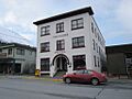
Van Gilder Hotel
The Van Gilder Hotel on Adams Street was an important hotel in Seward, serving travelers and residents. It's a landmark from the city's early development.
Other Notable Sites
The Kenai Peninsula has other interesting historic places scattered across its vast landscape.
Alaska Nellie's Homestead
Located at Mile 23 on the Seward Highway, Alaska Nellie's Homestead belonged to a famous Alaskan pioneer woman named Nellie Neal Lawing. She was known for her adventurous spirit and hospitality.
Cooper Landing Historic District
The town of Cooper Landing has a historic district along Alaska Route 1. It includes buildings and areas that tell the story of this community, which grew around mining and fishing.
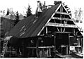
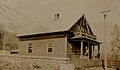
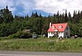
Cooper Landing Post Office
Also on the Sterling Highway in Cooper Landing, the historic post office is a small but important building that served the community for decades.
Harry A. Johnson Trapline Cabin
About 20 miles south of Hope, this trapline cabin shows the life of a trapper in the Alaskan wilderness. Trapping was a common way of life for many early Alaskans.
Lauritsen Cabin
North of Moose Pass, off the Seward Highway, the Lauritsen Cabin is another example of a historic wilderness dwelling.
Soldotna Post Office
In Soldotna, at the corner of E. Corral Street and the Kenai Spur Highway, the historic post office is a significant building in the town's development.
Thorn-Stingley House
In Homer, on East End Road, the Thorn-Stingley House is a historic residence that reflects the architectural styles and lives of early residents in the area.
Images for kids
-
Alaska Central Railroad Tunnel No. 1
-
Andrew Berg Cabin
-
Cooper Landing Post Office
-
Hope Historic District
-
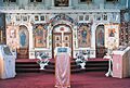
St. Nicholas Chapel interior
-
Sts. Sergius and Herman of Valaam Church
-
Government Cable Office
-
Seward Depot
-
Lowell Creek Diversion Tunnel
-
St. Peter's Episcopal Church
-
Thorn-Stingley House
-
Van Gilder Hotel
-
Yukon Island Main Site


