
National Register of Historic Places listings in Okanogan County, Washington facts for kids
The National Register of Historic Places (NRHP) is like a special list of important places in the United States. These places could be buildings, sites, structures, objects, or even entire areas that have a lot of history, special architecture, or are important to how our country developed. When a place is added to the NRHP, it means it's recognized as worth saving and protecting for future generations.
In Okanogan County, Washington, there are many cool places on this list. Let's explore some of them!
Historic Places in Okanogan County
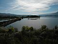
Chief Joseph Memorial

The Chief Joseph Memorial is a special place near Nespelem. It honors Chief Joseph, a famous leader of the Nez Perce people. He was known for his wisdom and his efforts to protect his people's land and way of life. This memorial helps us remember his important story and the history of Native American tribes in the area. It was added to the NRHP on May 15, 1974.
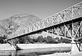
Columbia River Bridge at Bridgeport

The Columbia River Bridge at Bridgeport is a bridge that crosses the mighty Columbia River. Bridges are super important because they connect communities and help people travel and trade. This bridge is recognized for its engineering and its role in connecting different parts of Washington state. It became an NRHP site on May 31, 1995.
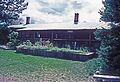
Early Winters Ranger Station Work Center

Located in the beautiful Okanogan National Forest near Winthrop, the Early Winters Ranger Station Work Center is a historic site. Ranger stations are places where forest rangers live and work, helping to manage and protect our national forests. This center shows how people used to work in these remote areas and how important it was to care for the environment. It was listed on the NRHP on April 11, 1986.
Enloe Dam and Powerplant

The Enloe Dam and Powerplant is about 4 miles (6.4 km) west of Oroville. Dams are big structures built across rivers to control water flow, often to create electricity (hydroelectric power) or to store water for irrigation. This dam and powerplant are important examples of early engineering and how communities used natural resources. It joined the NRHP on October 18, 1978.
Fort Okanogan

The Sites of Fort Okanogan are located north of Bridgeport, where the Columbia and Okanogan Rivers meet. This was a very important spot in early Washington history. It was a trading post where Native Americans, fur traders, and explorers met and exchanged goods. Learning about Fort Okanogan helps us understand the early days of settlement and trade in the Pacific Northwest. It was added to the NRHP on June 4, 1973.
Grand Coulee Bridge

The Grand Coulee Bridge spans the Columbia River near Grand Coulee. This bridge is part of a larger historical theme of important bridges and tunnels in Washington. It's a great example of how engineers built structures to help people cross large rivers and connect different areas. This bridge was listed on the NRHP on July 16, 1982.
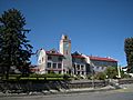
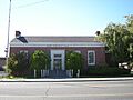
Okanogan County Courthouse

The Okanogan County Courthouse, located in Okanogan, is where many important government decisions for the county are made. Courthouses are often grand buildings that show the history of local government and justice. This building has been a central part of the community for many years. It was recognized on the NRHP on June 29, 1995.
Okanogan Project: Conconully Reservoir Dam

South of Conconully, you'll find the Conconully Reservoir Dam, which is part of the larger Okanogan Project. This project was important for managing water resources, especially for farming in the area. Dams like this help store water and provide it to farms, making dry land productive. It was added to the NRHP on September 6, 1974.
Historic Post Offices
Post offices are more than just places to send mail; they are often important community buildings.
- The U.S. Post Office – Okanogan Main in Okanogan is a historic building that has served the community for a long time. It was listed on the NRHP on May 30, 1991.
- The U.S. Post Office – Omak Main in Omak is another historic post office building. It also joined the NRHP on May 30, 1991.


Guy Waring Cabin

The Guy Waring Cabin is located in Winthrop. Cabins like this often tell stories of early settlers and pioneers who came to the area. They show us how people lived and built homes in the past, often in challenging environments. This cabin was added to the NRHP on March 19, 1982.
Images for kids
-
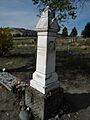
The Chief Joseph Memorial near Nespelem.
-
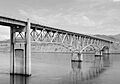
The Columbia River Bridge at Bridgeport.
-
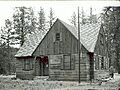
The Early Winters Ranger Station.
-
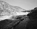
The Enloe Dam.
-
The site of Fort Okanogan.
-
The Grand Coulee Bridge.
-
The Okanogan County Courthouse.
-
The Conconully Reservoir Dam.
-

The Okanogan Main US Post Office.
-
The Omak Main US Post Office.
-
The Guy Waring Cabin.
See also
- National Register of Historic Places listings in Washington state
- Listings in neighboring counties: Chelan, Douglas, Ferry, Grant, Lincoln, Skagit, Whatcom
- Historic preservation
- History of Washington (state)
- Index of Washington-related articles
External links
- Washington Department of Archaeology and Historic Preservation, Historic Register program
- National Park Service, National Register of Historic Places site
