
National Register of Historic Places listings in Tooele County, Utah facts for kids

Have you ever wondered about the cool old buildings and places in your area? In Tooele County, Utah, there are many special spots that are part of the National Register of Historic Places. This is a list of important buildings, sites, and objects across the United States that are worth preserving because of their history, architecture, or what they mean to a community.
Tooele County has 29 places on this list, and one of them is even a National Historic Landmark! This means it's super important to the history of the whole country. Let's explore some of these amazing places and learn about their stories.
Contents
Cool Historic Places in Tooele County
Bonneville Salt Flats Race Track

Imagine a place so flat and smooth, it's like a giant mirror. That's the Bonneville Speedway, located near Wendover, Utah. This amazing natural area is famous around the world for setting land speed records! Since the early 1900s, people have brought special cars, motorcycles, and even jet-powered vehicles here to see how fast they can go. It's a truly unique place where history is made at incredible speeds.
Danger Cave

Near Wendover, there's a place called Danger Cave. It might sound a bit scary, but it's actually super important for understanding ancient history! This cave is a National Historic Landmark because archaeologists found tools, baskets, and other items left by people who lived there over 11,000 years ago. It's like a time capsule that tells us about the very first people in Utah and how they lived.
Benson Mill

The Benson Mill in Stansbury Park, Utah is a historic grist mill. What's a grist mill? It's a place where grain, like wheat or corn, is ground into flour. This mill was built a long time ago and shows us how people used to make food before modern factories. It's a cool example of early industry in Utah and how communities provided for themselves.
Iosepa Settlement Cemetery

In a quiet area called Skull Valley, you'll find the Iosepa Settlement Cemetery. This cemetery is a special reminder of a unique community. In the late 1800s, a group of Hawaiian settlers came to Utah and created a town called Iosepa. They worked hard to build a life in a very different environment. The cemetery is a tribute to their courage and their story, showing how diverse Utah's history is.
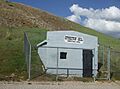
Lincoln Highway Bridge
.jpg)
Have you ever heard of the Lincoln Highway? It was one of the very first roads that stretched all the way across the United States! In Dugway Proving Ground, there's a bridge called the Lincoln Highway Bridge. This bridge is a piece of that historic road, reminding us of a time when cross-country travel was a big adventure and roads were just starting to connect the nation.
Wendover Air Force Base

The Wendover Air Force Base near Wendover, Utah played a huge role in World War II. This is where pilots trained for some of the most important missions of the war. It's a place with a lot of history, showing the efforts and sacrifices made during a critical time for the world.
Historic Buildings in Tooele City


The city of Tooele, Utah has several buildings on the National Register that tell its story:
- Tooele Carnegie Library: This beautiful building was once a library, built with money from famous businessman Andrew Carnegie. Many towns across the U.S. have Carnegie libraries, and they represent a time when public libraries were becoming very important for education.
- Tooele County Courthouse and City Hall: This building has been the center of local government for a long time. It's where important decisions for the county and city are made, and its architecture shows the style of its time.
- Tooele Valley Railroad Complex: Railroads were super important for connecting towns and moving goods and people in the past. This complex shows what a busy railroad hub looked like, with buildings related to trains and transportation.
Other Notable Historic Homes and Buildings
Many other homes and buildings in Tooele County are also on the National Register, often because of their unique architecture or the important people who lived in them. These include:
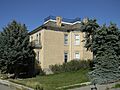
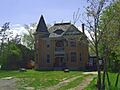
- The Anderson-Clark Farmstead and Hilda Erickson House in Grantsville, Utah, which show us what early farm life was like.
- The David E. Davis House in Rush Valley, Utah.
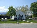
- The Grantsville First Ward Meetinghouse and Grantsville School and Meetinghouse in Grantsville, which were important community gathering places.
- The Johnson Hall-Deseret Mercantile Building and Alex and Mary Alice Johnson House in Grantsville, showing early businesses and homes.
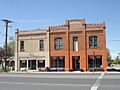
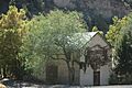
- The Lawrence Brothers and Company Store, Ophir Town Hall, and Reddick Hotel-Ophir LDS Meetinghouse in Ophir, Utah, which tell the story of this historic mining town.
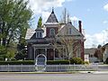
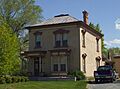
- The John T. Rich House in Grantsville and the John C. Sharp House in Vernon, Utah.
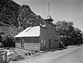
- The Stockton Jail in Stockton, Utah, a reminder of early law enforcement.
- The James and Penninah Wrathall House in Grantsville.
Each of these places has a unique story that helps us understand the history and development of Tooele County and Utah!
Images for kids
-
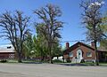
The Anderson-Clark Farmstead.
-
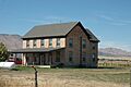
The David E. Davis House.
-
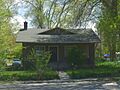
The Hilda Erickson House.
-
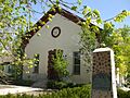
The Grantsville First Ward Meetinghouse.
-
The Grantsville School and Meetinghouse, now the Donner-Reed Museum.
-
The Johnson Hall-Deseret Mercantile Building.
-
The Alex and Mary Alice Johnson House.
-
The Lawrence Brothers and Company Store in Ophir.
-
The Ophir Town Hall.
-
The Reddick Hotel-Ophir LDS Meetinghouse.
-
The John T. Rich House.
-
The John C. Sharp House in Vernon.
-

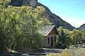
Soldier Creek Kilns (address restricted).
-
The Stockton Jail.
-
The James and Penninah Wrathall House.


