
National Register of Historic Places listings in Washington County, Utah facts for kids

Did you know that many old and important places in Washington County, Utah are officially recognized for their history? These special spots are listed on something called the National Register of Historic Places. It's like a national list of treasures that are important to America's past.
Washington County, located in Utah, has 78 places on this list! Some of these, about 25 of them, are inside Zion National Park. This article will tell you about the other 52 amazing historic places you can find in Washington County.
Contents
Exploring Washington County's Historic Places
Washington County is full of history, from old homes to important community buildings and even ancient sites. Let's explore some of these cool places!
Historic Homes and Buildings
Many of the listed places are old homes or buildings that show us how people lived long ago.
Famous Homes
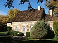
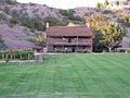
- Jacob Hamblin House: This home in Santa Clara, Utah belonged to Jacob Hamblin, an early settler who was known for his peaceful relationships with Native American tribes. It was built in 1863 and is a great example of pioneer architecture.
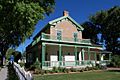
- Brigham Young Winter Home and Office: In St. George, Utah, you can find the winter home of Brigham Young, a very important leader in Utah's history. He spent his winters here, and the house shows how he lived and worked. It was built in 1871.
- Wallace Blake House: Located south of St. George, this house was added to the list in 1978. It's an example of the kind of homes built in the area during its early development.
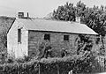
- William F. Butler House: Another historic home in St. George, listed in 1984. It helps us understand the architectural styles of the past.
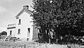
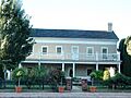
- Robert D. Covington House: This house in Washington, Utah was listed in 1978 and is a significant part of the town's history.
- George and Bertha Graff House: Found in Santa Clara, this home was added to the register in 1998. It tells a story about the families who settled the area.
- Hans George Hafen House: Also in Santa Clara, this house from 1998 is another example of the area's pioneer homes.
- Thomas Judd House: A St. George home listed in 1978.
- Lemuel and Mary Ann Leavitt House: This Santa Clara home was listed in 1999.
- Orson Pratt House: In St. George, this house belonged to Orson Pratt, another important early leader. It was listed in 1983.
- Frederick and Anna Maria Reber House: This Santa Clara home was listed in 1998.
- Frederick, Jr., and Mary F. Reber House: Another Reber family home in Santa Clara, listed in 1999.
- Emanuel and Ursella Stanworth House: This Hurricane home was listed in 1992.
- John Steele House: Located in Toquerville, Utah, this house was listed in 1988.
Community Buildings
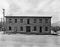
- Old Washington County Courthouse: In St. George, this beautiful old courthouse was built in 1876 and is a symbol of early government in the county. It was listed in 1970.
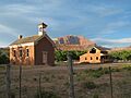
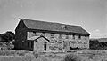
- Pine Valley Chapel and Tithing Office: This unique chapel in Pine Valley, Utah was built in 1868 and is known for its interesting design. It was listed in 1971.
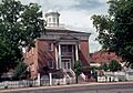
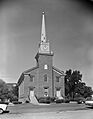
- St. George Tabernacle: A very important building in St. George, built between 1863 and 1875. It's a large, historic meeting place and was listed in 1971.
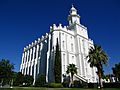
- St. George Utah Temple: This temple in St. George is a significant religious building, completed in 1877. It was listed in 1977.
- Deseret Telegraph and Post Office: In Rockville, Utah, this building was once a telegraph office and post office, connecting early settlers to the outside world. It was listed in 1972.
- Enterprise Meetinghouse: This meetinghouse in Enterprise, Utah was listed in 1993.
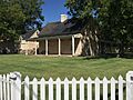
- Hurricane Library-City Hall: This building in Hurricane, Utah served as both a library and city hall and was listed in 1991.
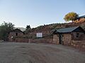
- Leeds CCC Camp Historic District: This site in Leeds, Utah was a camp for the Civilian Conservation Corps (CCC) during the Great Depression, a program that helped people find work. It was listed in 1993.
- Leeds Tithing Office: This office in Leeds was listed in 1985.
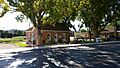
- Main Building of Dixie College: This building in St. George was an important part of Dixie College (now Utah Tech University). It was listed in 1980.
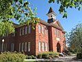
- St. George Elementary School: This old school in St. George was listed in 1985.
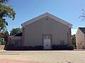
- St. George Social Hall: A place for community gatherings in St. George, listed in 1991.
- Santa Clara Relief Society House: This building in Santa Clara was used by the Relief Society, a women's organization, and was listed in 1994.
- Santa Clara Tithing Granary: A granary in Santa Clara where people stored goods as tithes, listed in 1998.
- Washington Cotton Factory: This factory in Washington was important for early cotton production in the area. It was listed in 1971.
- Washington Relief Society Hall: Another Relief Society hall, this one in Washington, listed in 1980.
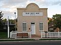
- Washington School: This old school in Washington is now a museum and was listed in 1980.
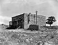
- Wells Fargo and Company Express Building: Located in Silver Reef, Utah, this building was part of the famous Wells Fargo company, listed in 1971.
- Woodward School: This school in St. George was listed in 1980.
Important Waterways and Structures
Water was (and still is!) super important for life in Washington County. Several historic canals and bridges are on the list.
- Crawford Irrigation Canal: This canal near Springdale, Utah was vital for bringing water to farms and communities. It was listed in 1987.
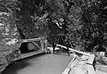
- Hurricane Canal: East of Hurricane, this canal was a huge project that helped develop the area. It was listed in 1977.
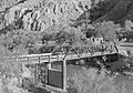
- Hurricane-LaVerkin Bridge: This bridge over the Virgin River connects Hurricane and LaVerkin and was listed in 1995.
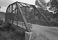
- Rockville Bridge: This bridge in Rockville crosses the East Fork of the Virgin River and was listed in 1995.
- Santa Clara Hydroelectric Power Plants Historic District: This district near Gunlock, Utah and Veyo, Utah includes old power plants that used water to create electricity. It was listed in 1989.
- Shem Dam: This dam near Ivins, Utah was listed in 2017.
Other Significant Historic Sites
Some places on the list are not buildings but important historical areas.
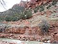
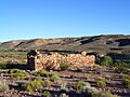
- Fort Harmony Site: East of New Harmony, Utah, this was the site of an early fort, listed in 1979.
- Fort Pearce: Southeast of Washington, this old fort site was listed in 1975.
- Grafton Historic District: This district in Rockville includes the remains of the historic town of Grafton, which was settled in the 1850s. It was listed in 2010.
- Hurricane Historic District: This area in Hurricane includes many historic buildings and was listed in 1995.
- Mountain Meadows Historic Site: This site near Enterprise is a very important historical location. It was listed in 1975 and later became a National Historic Landmark in 2011. It's a place where a tragic event happened in 1857, and it's preserved to remember the past.
- Naegle Winery: In Toquerville, this winery was listed in 1980 and shows an interesting part of the area's agricultural history.
- Southern Paiute Archeological District: This district near Washington contains important archaeological sites related to the Southern Paiute people, showing their long history in the region. It was listed in 1982.
Images for kids
-
Wallace Blake House
-
William F. Butler House
-
Robert D. Covington House
-
Crawford Irrigation Canal
-
Deseret Telegraph and Post Office
-
Fort Pearce
-
George and Bertha Graff House
-
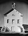
Grafton Schoolhouse in the Grafton Historic District
-

Hans George Hafen House
-
Jacob Hamblin House
-
Hurricane Canal
-
Hurricane-LaVerkin Bridge
-
Leeds CCC Camp
-
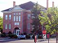
Main Building of Dixie College
-
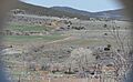
Mountain Meadows Historic Site
-
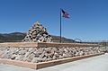
Mountain Meadows Massacre Site
-
Naegle Winery
-
Old Washington County Courthouse
-
Pine Valley Chapel
-
Orson Pratt House
-
Rockville Bridge
-
St. George Social Hall
-
St. George Tabernacle
-
St. George Temple
-
Santa Clara Relief Society House
-
Washington Cotton Factory
-
Wells Fargo and Company Express Building
-
Woodward School
-
Brigham Young Winter Home and Office


