
Needle Mountain facts for kids
Quick facts for kids Needle Mountain |
|
|---|---|

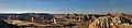
South aspect at sunset
|
|
| Highest point | |
| Elevation | 6,620 ft (2,020 m) |
| Prominence | 240 ft (73 m) |
| Isolation | 0.60 mi (0.97 km) |
| Parent peak | Cathedral Mountain (6,924 ft) |
| Geography | |

Needle Mountain
Location in Utah

Needle Mountain
Location in the United States
|
|
| Location | Capitol Reef National Park Wayne County, Utah, US |
| Parent range | Colorado Plateau |
| Topo map | USGS Cathedral Mountain |
| Geology | |
| Age of rock | Jurassic |
| Type of rock | Entrada Sandstone |
Needle Mountain is a cool peak in Capitol Reef National Park in Utah, USA. It stands tall at 6,620 feet (about 2,020 meters) high! This amazing rock formation is found in Wayne County. It's pretty far out, about 16 miles (26 km) north-northwest of the park's main visitor center.
Needle Mountain is part of the "Cathedral Valley" area. This valley got its name in 1945 from Charles Kelly. He was the first boss of Capitol Reef National Monument. The giant sandstone rocks in the valley reminded early explorers of fancy, old churches called cathedrals. Needle Mountain itself rises 240 feet (73 meters) above the ground around it. The famous explorer John C. Frémont even passed through this valley way back in 1853!
How Needle Mountain Formed
Needle Mountain is made of a type of rock called Entrada Sandstone. This sandstone started as sandy mud on a huge tidal flat. Scientists think it formed about 160 million years ago. This was during the Jurassic period, when dinosaurs roamed the Earth! Back then, this area was a giant sea of sand, the biggest one in Earth's history.
The layers of rock in Cathedral Valley look almost flat. They only tilt a little bit, about three to five degrees to the east. A long time after these sandy layers were laid down, the whole Colorado Plateau slowly lifted up. This lifting kept the rock layers mostly flat. But Capitol Reef is special because of something called the Waterpocket Fold. This is a huge bend in the rock layers, like a giant wrinkle! It formed between 50 and 70 million years ago.
Weather at Needle Mountain
The best times to visit Needle Mountain are in spring and fall. The weather is usually just right then. The area has a Cold semi-arid climate. This means the coldest month usually has an average temperature below 32°F (0°C). Also, at least half of the yearly rain falls during spring and summer.
This desert area gets less than 10 inches (250 mm) of rain each year. Snowfall in winter is usually light. The table below shows more details about the weather near Needle Mountain.
| Climate data for Capitol Reef Visitor Center, elevation 5,653 ft (1,723 m), 1981-2010 normals, extremes 1981-2019 | |||||||||||||
|---|---|---|---|---|---|---|---|---|---|---|---|---|---|
| Month | Jan | Feb | Mar | Apr | May | Jun | Jul | Aug | Sep | Oct | Nov | Dec | Year |
| Record high °F (°C) | 58.6 (14.8) |
68.3 (20.2) |
78.3 (25.7) |
84.4 (29.1) |
94.6 (34.8) |
100.2 (37.9) |
100.8 (38.2) |
97.9 (36.6) |
95.4 (35.2) |
86.1 (30.1) |
70.4 (21.3) |
61.5 (16.4) |
100.8 (38.2) |
| Mean daily maximum °F (°C) | 40.6 (4.8) |
46.4 (8.0) |
54.7 (12.6) |
65.0 (18.3) |
74.5 (23.6) |
85.3 (29.6) |
90.4 (32.4) |
87.9 (31.1) |
80.2 (26.8) |
66.1 (18.9) |
51.3 (10.7) |
40.6 (4.8) |
65.3 (18.5) |
| Mean daily minimum °F (°C) | 17.8 (−7.9) |
22.7 (−5.2) |
30.2 (−1.0) |
36.2 (2.3) |
44.7 (7.1) |
53.1 (11.7) |
60.4 (15.8) |
58.5 (14.7) |
50.4 (10.2) |
39.0 (3.9) |
27.6 (−2.4) |
18.2 (−7.7) |
38.3 (3.5) |
| Record low °F (°C) | −4.2 (−20.1) |
−11.8 (−24.3) |
9.1 (−12.7) |
18.1 (−7.7) |
27.2 (−2.7) |
34.6 (1.4) |
42.4 (5.8) |
45.1 (7.3) |
29.9 (−1.2) |
11.7 (−11.3) |
8.0 (−13.3) |
−7.5 (−21.9) |
−11.8 (−24.3) |
| Average precipitation inches (mm) | 0.52 (13) |
0.34 (8.6) |
0.53 (13) |
0.47 (12) |
0.59 (15) |
0.47 (12) |
0.91 (23) |
1.20 (30) |
0.80 (20) |
0.98 (25) |
0.49 (12) |
0.32 (8.1) |
7.62 (194) |
| Average dew point °F (°C) | 17.3 (−8.2) |
20.8 (−6.2) |
23.0 (−5.0) |
24.5 (−4.2) |
29.1 (−1.6) |
32.0 (0.0) |
40.0 (4.4) |
41.8 (5.4) |
34.8 (1.6) |
28.2 (−2.1) |
21.9 (−5.6) |
17.5 (−8.1) |
27.6 (−2.4) |
| Source: PRISM | |||||||||||||
Gallery
-
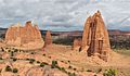
Cathedral Mountain (left), Needle Mountain (right), from the southeast
-
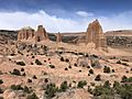
Cathedral Mountain (left), Needle Mountain (right)
-
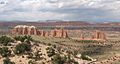
"The Cathedrals" with Needle Mountain to right
-
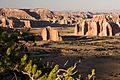
Needle Mountain left of center
-
Cathedral Valley sunset, with Needle Mountain left of center


.jpg)
