New River (Oregon) facts for kids
Quick facts for kids New River |
|
|---|---|

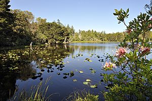
Mud Lake at New River ACEC in June
|
|
|
Location of the mouth of the New River in Oregon
|
|
| Country | United States |
| State | Oregon |
| County | Curry and Coos |
| Physical characteristics | |
| Main source | Confluence of Floras Lake outlet with Floras Creek near Langlois, Curry County, Oregon 13 ft (4.0 m) 42°54′48″N 124°29′51″W / 42.91333°N 124.49750°W |
| River mouth | Pacific Ocean south of Bandon State Natural Area, Coos County, Oregon, United States 3 ft (0.91 m) 43°00′02″N 124°27′30″W / 43.00056°N 124.45833°W |
| Length | 8 mi (13 km) |
| Discharge (location 2) |
|
| Basin features | |
| Basin size | 126 sq mi (330 km2) |
The New River is a stream about 8 miles (13 km) long. It flows along the southern coast of Oregon in the United States. This river starts slightly north of Floras Lake. It forms where the lake's water joins Floras Creek. The river then flows north, hidden behind a large sand dune, until it reaches the Pacific Ocean. Its mouth is located between the towns of Bandon and Port Orford.
The river got its name because it is quite "new"! It formed in 1890 during a big storm. Sand blocked the usual way for Floras Lake to drain. This caused a flood that carved out a new path for the water behind the sand dune. Water from Floras Creek, which is about 21 miles (34 km) long, also flows into this new channel. The New River is very flat, dropping only about 10 feet (3 m) in height from where it starts to where it meets the ocean.
Contents
How the New River Formed
The area where the New River now flows has a long history. About 8,000 years ago, long before the river existed, ancestors of the Siletz and Coquille tribes lived here. They had large villages near a river mouth, called an estuary.
On January 26, 1700, a huge tsunami hit the coast. This giant wave, about 30 feet (9 m) high, changed the landscape a lot. After this big event, strong winds blew sand around. This sand blocked streams and created new wet areas behind the sand dunes. These changes set the stage for the New River to appear much later.
Wildlife and Habitats
The area around the New River is very special for nature. It is located between Bandon to the north and Cape Blanco to the south. This region has many state, federal, and county parks. It also has places for recreation and wildlife.
One important area is the New River Area of Critical Environmental Concern (ACEC). The Bureau of Land Management (BLM) looks after this area. The BLM wants people to enjoy the 1,200-acre (486 ha) site. At the same time, they work hard to protect the homes for native plants, birds, animals, and fish.
Protecting the Dunes and Wildlife
In the early 1900s, a plant called European beachgrass was planted here. It is an invasive species, meaning it's not native to the area. It was planted to help hold the sand dunes in place. These dunes can grow as high as 30 feet (9 m). The beachgrass did help keep the river in its new channel. However, it also pushed out native plants like sand verbena. This changed the natural homes for birds and other animals.
The New River area is a unique spot for hummingbirds. It's the southernmost place where rufous hummingbirds have been seen breeding. It's also the most northern place for Allen's hummingbirds to breed. Snowy plovers live here all year long. To protect these nesting plovers, some parts of the ACEC are closed to people. This closure happens from March 15 to September 15.
Spring is a busy time for birds here. About 20,000 Aleutian cackling geese (a type of small goose) fly through. Nearly 100,000 shorebirds also visit during their migration.
Fun Activities at the New River
The New River ACEC is made up of four main parts: Storm Ranch, Floras Lake, Fourmile Creek, and Lost Lake. These areas are connected by hiking trails. You can find parking, restrooms, and a Nature Center here. River Road is a gravel path that leads from the parking area to a boat ramp on the New River. This road is great for biking, horseback riding, and walking.
Boating and Fishing
If you like canoeing or kayaking, you can start at Floras Lake. You can float down the lake's outlet and then onto the New River. There are two places to take your boat out. One is at Storm Ranch, which is about an 8-mile (13 km) trip. The other is at Lower Fourmile Road, about a mile further downstream. The Lower Fourmile takeout requires carrying your boat about 0.2 miles (0.3 km) to a parking lot. The Storm Ranch route might also need a short carry, as the gate to River Road is closed to cars from March 15 to September 15.
The New River is home to several types of fish. These include Chinook salmon and other fish that travel between fresh and salt water. Fishing for coho salmon is not allowed here. But you can fish for Chinook salmon, steelhead, and searun cutthroat trout. You can fish from the river banks or from boats without motors. Surfperch are often found near the river's mouth.
 | Janet Taylor Pickett |
 | Synthia Saint James |
 | Howardena Pindell |
 | Faith Ringgold |


