Newport, Queensland facts for kids
Quick facts for kids NewportQueensland |
|||||||||||||||
|---|---|---|---|---|---|---|---|---|---|---|---|---|---|---|---|
 |
|||||||||||||||
| Population | 5,964 (2021 census) | ||||||||||||||
| • Density | 1,491/km2 (3,860/sq mi) | ||||||||||||||
| Established | 2008 | ||||||||||||||
| Postcode(s) | 4020 | ||||||||||||||
| Area | 4.0 km2 (1.5 sq mi) | ||||||||||||||
| Time zone | AEST (UTC+10:00) | ||||||||||||||
| Location |
|
||||||||||||||
| LGA(s) | City of Moreton Bay | ||||||||||||||
| State electorate(s) |
|
||||||||||||||
| Federal Division(s) | Petrie | ||||||||||||||
|
|||||||||||||||
Newport is a coastal suburb in Queensland, Australia. It is part of the City of Moreton Bay. In 2021, Newport had a population of 5,964 people.
Contents
Exploring Newport's Location
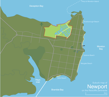
Newport is located at the northern end of the Redcliffe Peninsula. It is about 29 kilometres (18 miles) north-northeast of Brisbane. Brisbane is the capital city of Queensland, Australia.
The Story of Newport
Newport officially became a suburb on 15 August 2008. Before this, parts of Newport were actually areas of Scarborough and Kippa-Ring. The name Newport comes from the "Newport Waterways" housing area. This development started in the late 1970s. The first artificial canals in the area were filled with water in 1979.
Community and Safety
In 1985, people living in Newport formed a group called the Newport Waterways Property Owners Association (NWPOA). This group works to keep the canals and marine environment clean. In 1986, they started "Newport Watch." This program helps improve community safety and offers social services to people living near the canals.
Growing the Suburb
The first part of the Newport Waterways housing area involved changing swampy land into new areas for homes. The first two housing estates were finished by the early 1990s. These areas were north and south of Griffith Road.
Later, in the mid-to-late 1990s, new canals were built. A bridge over the main waterway, Albatross Canal, was completed in 2000. A small part of land was sold in the early 2000s for the "Isles Of Newport" estate. This area included a large park for residents.
Future Plans for Newport
The Redcliffe Peninsula railway line was built about 1.5 kilometres (0.93 miles) from the centre of Newport. Because of this, and the fast growth of the Moreton Bay Region, a company called Stockland bought a lot of land in Newport in 2014. This land will be used to complete the final stages of Newport's development. These plans include a shopping area, a large lake, and many new house lots.
Fun at Spinnaker Park
Newport is home to Spinnaker Park. This park was voted Australia's Favourite Playground in 2021. It's a great place for families and kids to have fun!
Newport's Population
In 2016, Newport had a population of 2,964 people. By 2021, the population had grown to 5,964 people.
Newport's Economy
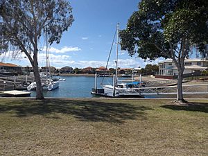
Newport is mostly known for its homes built along artificial canal waterways. It is also close to the busy seafood industry at the Scarborough Boat Harbour.
Learning in Newport
Several schools are close to Newport:
- Southern Cross Catholic College is in nearby Scarborough.
- Scarborough State School is a government primary school in Scarborough.
- Hercules Road State School is another government primary school in Kippa-Ring.
- The closest government high school is Redcliffe State High School in Redcliffe.
Community Activities and Parks
The Newport Waterways Property Owners Association (NWPOA) offers many community services. These include regular newsletters called "The Newport News." They also organize fun events like Santa visiting the canals at Christmas, "Sundowners" in the park, and "Christmas in July" gatherings.
Newport has two yacht clubs:
- Newport Cruising Yacht Club
- Moreton Bay Boat Club
These clubs have regular sailing competitions.
Newport is also home to the Newport Game Fishing Club. This club competes in both Moreton Bay and offshore waters.
There are many parks in Newport where you can play and relax:
- Ashmole Road Park (27°12′43″S 153°06′10″E / 27.2119°S 153.1029°E)
- Atlanta Court Park (27°12′32″S 153°06′13″E / 27.2088°S 153.1036°E)
- Boardman Road Park (27°13′05″S 153°05′07″E / 27.2181°S 153.0854°E)
- Cooper Park (27°12′24″S 153°06′05″E / 27.2066°S 153.1014°E)
- Hubner Park (27°12′20″S 153°05′55″E / 27.2055°S 153.0985°E)
- Jim Findlay Park (27°12′03″S 153°06′09″E / 27.2009°S 153.1024°E)
- Madeleine Court Park (27°12′38″S 153°06′12″E / 27.2105°S 153.1033°E)
- Morgan Park (27°12′27″S 153°06′06″E / 27.2074°S 153.1018°E)
- Newport Park (27°13′00″S 153°05′06″E / 27.2167°S 153.0849°E)
- Southern Cross Park (27°12′19″S 153°05′45″E / 27.2054°S 153.0959°E)
- Talobilla Park (27°13′04″S 153°05′32″E / 27.2179°S 153.0921°E)
 | Precious Adams |
 | Lauren Anderson |
 | Janet Collins |


