Kippa-Ring, Queensland facts for kids
Quick facts for kids Kippa-RingQueensland |
|||||||||||||||
|---|---|---|---|---|---|---|---|---|---|---|---|---|---|---|---|
 |
|||||||||||||||
| Population | 9,745 (2021 census) | ||||||||||||||
| • Density | 1,805/km2 (4,670/sq mi) | ||||||||||||||
| Established | 1971 | ||||||||||||||
| Postcode(s) | 4021 | ||||||||||||||
| Elevation | 6 m (20 ft) | ||||||||||||||
| Area | 5.4 km2 (2.1 sq mi) | ||||||||||||||
| Time zone | AEST (UTC+10:00) | ||||||||||||||
| Location |
|
||||||||||||||
| LGA(s) | City of Moreton Bay | ||||||||||||||
| Region | South East Queensland | ||||||||||||||
| State electorate(s) |
|
||||||||||||||
| Federal Division(s) | Petrie | ||||||||||||||
|
|||||||||||||||
Kippa-Ring is a suburb located in the City of Moreton Bay, Queensland, Australia. It's a busy place on the Redcliffe Peninsula. In 2021, about 9,745 people lived here.
Contents
Exploring Kippa-Ring's Location
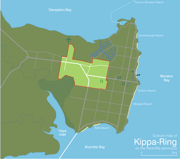
Kippa-Ring is right in the middle of the Redcliffe Peninsula. It's about 2.9 kilometers (1.8 miles) west of Redcliffe. It is also about 31.5 kilometers (19.6 miles) north-north-east of Brisbane, Queensland's capital city.
This suburb is known as the main shopping and business area for the Redcliffe region. You'll find most of the big shops and businesses here.
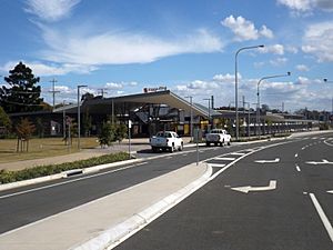
The Kippa-Ring railway station is on Hindmarsh Street. It's the last stop on the Redcliffe Peninsula railway line. This makes it easy to travel to and from Kippa-Ring.
A Look at Kippa-Ring's Past
The name Kippa-Ring comes from a mix of words. "Kippa" is a word from the Kabi language. It means a young man who has not yet been initiated. "Ring" refers to a special place called a bora ring. This was a circular area used for important ceremonies by Indigenous Australians.
Old maps used to show this bora ring as a landmark. Even before Kippa-Ring became an official suburb, this name was used for the area. For example, the swampy land in the north was called 'Kippering Swamp'. This area later became part of the Newport canal development.
Until the 1950s and 1960s, Kippa-Ring was mostly empty land. It was used for farming or small businesses. In the 1960s and 1970s, many homes were built. Kippa-Ring officially became a suburb in 1971.
Two primary schools opened in Kippa-Ring:
- Kippa-Ring State School opened on January 25, 1960.
- Hercules Road State School opened on January 27, 1976.
Who Lives in Kippa-Ring?
In 2021, Kippa-Ring had a population of 9,745 people.
- About 4.0% of the people were Aboriginal and Torres Strait Islander.
- Most people (71.5%) were born in Australia.
- Other common birthplaces included New Zealand (7.2%) and England (5.1%).
- Most people (86.5%) spoke only English at home.
- When it came to religion, many people said they had no religion (30.2%). Others were Catholic (21.3%) or Anglican (15.7%).
Important Places: Heritage Listings
Kippa-Ring has one special place listed for its history:
- Anzac Avenue (the road itself)
Learning in Kippa-Ring: Schools
Kippa-Ring has several schools for younger students.
Primary Schools
- Kippa-Ring State School is a government primary school for students from Prep to Year 6. It's located at 400 Elizabeth Avenue. In 2018, it had 355 students. It also has a special education program.
- Hercules Road State School is another government primary school for Prep to Year 6 students. It's on Hercules Road. In 2018, this school had 903 students. It also offers a special education program.
- Southern Cross Catholic College has one of its primary campuses in Kippa-Ring. This campus is for Prep to Year 6 students and is located at 110 Nottingham Street. The main campus for this college is in Scarborough.
- ACE Positive Learning Centre is a special primary school for students in Years 3 to 7. It's on Edmund Street. This center helps students who need extra support. It aims to help them return to a regular classroom or prepare for future jobs.
Secondary Schools
There are no secondary schools (high schools) directly in Kippa-Ring. Students usually go to nearby suburbs for high school. The closest government high schools are:
- Redcliffe State High School in Redcliffe
- Clontarf Beach State High School in Clontarf
- Deception Bay State High School in Deception Bay
Fun and Facilities in Kippa-Ring
Kippa-Ring is home to two of the biggest shopping centers on the Redcliffe Peninsula: Peninsula Fair and Kippa-Ring Shopping Centre. They are right next to each other, making it easy to walk between them.
- Peninsula Fair has one of the first Kmart stores in Queensland. It also has the only movie theater (multiplex cinemas) on the Redcliffe peninsula. Plus, there are about 90 other specialty stores. In 2017, Peninsula Fair was updated with new looks and seating areas.
- Kippa-Ring Shopping Centre was redeveloped in 2012. It added a Target store (which closed in 2021) and a new Woolworths. It also has about 40 other specialty stores.
Kippa-Ring also has the Peninsula Private Hospital. This is one of two hospitals on the Peninsula and the only private one.
Sports and Recreation
Talobilla Park in Kippa-Ring is a big sports hub. It's home to several sports clubs:
- The Redcliffe Padres (baseball club)
- The Redcliffe Dolphins (rugby league club)
- Redcliffe PCYC (softball)
- A club for canoe, dragon boat, and rowing sports.
The Peninsula Power football (soccer) club also plays at AJ Kelly Field.
Local Businesses
The suburb has a small industrial area near the shopping centers. This area provides many jobs for people on the Peninsula. It's one of two industrial centers in the area, the other being in Clontarf.
 | John T. Biggers |
 | Thomas Blackshear |
 | Mark Bradford |
 | Beverly Buchanan |


