
Anzac Avenue facts for kids
Quick facts for kids Anzac AvenueQueensland |
|
|---|---|
 |
|
| Mango Trees along Anzac Avenue at Mango Hill, Queensland. | |
| General information | |
| Type | Road |
| Length | 17.8 km (11 mi) |
| Route number(s) |
|
| Major junctions | |
| West end | |
|
|
| East end | |
| Location(s) | |
| Major suburbs | Petrie, Kallangur, North Lakes, Mango Hill, Rothwell, Kippa-Ring, Redcliffe |
Anzac Avenue is a special road in the Moreton Bay Region, Queensland, Australia. It's famous for its many trees and its history. The road stretches about 17.8 kilometers (11 miles) from Petrie to Redcliffe. Most of it is known as State Route 71. This road used to be the main way to get to the Redcliffe peninsula before the Hornibrook Bridge was built.
Anzac Memorial Avenue, as it was first called, opened in 1925. It is the longest World War I memorial road in Queensland. It was also the first paved road that connected Brisbane to the popular holiday spot of Redcliffe. This road shows how much car use grew in the early 1920s. It was added to the Queensland Heritage Register on February 5, 2009.
Today, Anzac Avenue helps people quickly reach the Peninsula Fair Shopping Centre. It is also the main road to the Redcliffe Hospital.
Contents
Exploring Anzac Avenue: The Route
How the Road Flows
The road starts in Petrie at a roundabout. Here, it meets State Route 58, which includes Gympie Road and Dayboro Road. Anzac Avenue then heads north and northeast through Kallangur. It crosses the Bruce Highway near North Lakes.
After passing the Westfield North Lakes shopping center, it continues northeast through areas like Mango Hill. It crosses Hays Inlet at Saltwater Creek. Then, it meets State Route 26 at Deception Bay Road. From there, it turns east through Rothwell and Kippa-Ring. It becomes only Route 71 at Elizabeth Avenue. Finally, it reaches Redcliffe, crosses State Route 27 at Oxley Avenue, and ends at a roundabout with Redcliffe Parade by the water.
Key Road Crossings
The entire road is located in the Moreton Bay Region.
| Location | km | mi | Destinations | Notes |
|---|---|---|---|---|
| Petrie | 0 | 0.0 | Roundabout; western start of Anzac Avenue and State Route 71 | |
| Kallangur | 5.6 | 3.5 | Interchange | |
| Kippa-Ring | 10.4 | 6.5 | Where State Route 26 joins Anzac Avenue | |
| Redcliffe | 14.6 | 9.1 | Where State Route 26 leaves Anzac Avenue and continues south | |
| 17.1 | 10.6 | State Route 71 eastern end | ||
| 17.8 | 11.1 | Redcliffe Parade north – Scarborough / Marine Parade south – Margate | Roundabout; Anzac Avenue eastern end | |
| 1.000 mi = 1.609 km; 1.000 km = 0.621 mi | ||||
The Story of Anzac Avenue
| Anzac Memorial Avenue | |
|---|---|
| Lua error in Module:Location_map at line 420: attempt to index field 'wikibase' (a nil value). | |
| Location | Anzac Avenue, Redcliffe, Moreton Bay Region, Queensland, Australia |
| Design period | 1919 - 1930s (interwar period) |
| Official name: Anzac Memorial Avenue (former) | |
| Type | state heritage (landscape, built) |
| Designated | 5 February 2009 |
| Reference no. | 602693 |
| Significant period | 1920s (fabric) 1920s-ongoing (historical use) |
| Significant components | tree groups - avenue of, road/roadway |
Getting to Redcliffe Peninsula Long Ago
The very first path along this route was an Aboriginal track. It led to Kippa Ring, where an important meeting place called a bora ring was located.
In 1859, Tom Petrie guided a group to Redcliffe from North Pine. By the early 1860s, a road from Bald Hills to Redcliffe existed, but it was hard to use. Tom Petrie helped survey a better road in the early 1870s. This road, known as the "Brisbane Road," became the main way to reach the Redcliffe Peninsula by land.
Redcliffe became a popular seaside resort from the late 1870s. People believed sea air and saltwater bathing were good for health. By the late 1880s, Redcliffe was the biggest tourist spot between Sandgate and Noosa Heads. Many guest houses and hotels were built for visitors.
However, the road was often in poor condition, especially in wet weather. This made trips between Brisbane and Redcliffe difficult. People tried for years to get a railway line built, but it didn't happen. By the 1920s, getting to Brisbane from Redcliffe could take up to four hours. Redcliffe needed a better connection to Brisbane to grow.
A Road as a Memorial
After World War I, many communities built memorials to remember those who lost their lives. Some memorials were statues, while others were useful things like hospitals or roads. These roads often provided jobs for soldiers returning from the war. Anzac Avenue is one such example. Over 200 "Avenues of Honour" were planted with trees across Australia as memorials.
Anzac Memorial Avenue was Queensland's largest project of this kind. People donated money to help build it. Most war memorials honored soldiers from a specific area. But Anzac Memorial Avenue was for everyone, including people from Brisbane who helped fund it.
In the early 1920s, more and more people started driving cars. This led to calls for better roads. In 1920, the Queensland government created the Main Roads Board. This board helped local councils build and manage roads.
Thomas James Rothwell, who was the President of the Royal Automobile Club of Queensland (RACQ), was key to creating Anzac Memorial Avenue. He wanted a good road for car touring near Brisbane. He also saw a chance to help unemployed soldiers returning from the war. He thought building a good road and planting trees along it would be a great way to honor soldiers and provide jobs.
The idea was presented to the Queensland Minister for Lands in 1922. He agreed the road would be important and suggested the name "Anzac Memorial Avenue." A committee was formed to raise money. They aimed to collect £20,000 to pay the soldiers working on the road. The Main Roads Board would pay for materials.
The public was asked to donate. A special board in Brisbane showed how much money was raised. "Anzac Avenue Badge Day" was held to sell car badges and collect funds. The Australian Government also helped by giving £12,000 for the Redcliffe road. This meant the goal of £20,000 was almost reached quickly.
The road was officially named "Redcliffe Road" in October 1922. It was one of the first roads built by the Main Roads Board to encourage car tourism. It was seen as the best road to a tourist resort from Brisbane at the time.
By December 1922, 25 returned soldiers began working on the road. By March 1923, there were 50. They cleared land, built bridges, and prepared materials. The road was paved with a special material called trachyte.
Anzac Memorial Avenue was officially opened on December 5, 1925. The acting Premier, William Forgan Smith, opened it. There was a big celebration in Petrie and Redcliffe. The road was praised as the best road to a tourist resort in Queensland.

After the road opened, efforts focused on planting trees. A committee was formed to choose suitable trees. They estimated that 1760 trees were needed for every 10 miles. The cost was less than £1 per tree. They chose a mix of native and introduced trees.
The first trees were planted in Petrie on February 28, 1925. Two Cocos palms were planted by Governor Nathan. These trees were donated by Elizabeth Petrie, whose husband, Tom Petrie, was a local pioneer. Donors could get a certificate for their contribution.
On July 7, 1926, another ceremony was held in Redcliffe. The Australian Governor-General, Lord Stonehaven, planted the first Hoop Pine tree. He hoped local school children would become "guardians of the trees."
By mid-1927, 1000 trees had been planted. However, some trees were damaged by fires, animals, or pests. By 1933, 2000 trees were planted, but some had not survived. The committee faced challenges with funding to extend the planting.
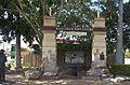
Thomas Rothwell, who was so important to the project, passed away in 1928. A monument was unveiled in his honor in 1933. It was placed at the intersection of Anzac Memorial Avenue and Deception Bay Road. Later, it moved to a nearby park.
Anzac Avenue Today
Anzac Memorial Avenue helped Redcliffe become a popular seaside resort. In 1928, people noted how much traffic passed through Petrie. The opening of the Hornibrook Bridge in 1935 made it even easier to get to Redcliffe.
For many years, the area around Anzac Memorial Avenue was mostly rural. Farms sold produce by the roadside. Over time, more houses were built, and the area became suburban. In 1971, the suburb of Rothwell was named after Thomas Rothwell.
The road has been widened over the years to handle more cars. Some trees were removed during these changes, which caused some debate. In 1993, a section of the road was officially reopened. In 2006, more trees were removed for a transit lane. However, new memorial trees were planted in Henry Pieper Park.
While the road was originally called Anzac Memorial Avenue, it is now commonly known as Anzac Avenue. Some of the original trees have not survived. But the Cocos palms planted in Petrie in 1925 and the Hoop Pine planted in Redcliffe in 1926 are still there.
New trees have been planted over time, keeping the idea of a memorial avenue alive. The section near Mango Hill is famous for its 700-meter stretch of Mango trees. There are also many Slash Pines between Kippa Ring and Rothwell.
Since the 1990s, new memorials have been added along the road. These honor Australian involvement in wars after 1945. Even with the Hornibrook Bridge, traffic on Anzac Avenue grew, leading to more road widening.
Today, Anzac Avenue is more than just a tourist drive. It's a busy road for residents in new suburbs like Rothwell and North Lakes. The road was added to the Queensland Heritage Register in 2009.
What Makes Anzac Avenue Special
The important parts of Anzac Avenue include its route, the views you see along the way, and the special trees planted there.
Anzac Memorial Avenue is about 18 kilometers long. It goes from Gympie Road in Petrie to the roundabout at Redcliffe Parade in Redcliffe. It travels northeast through Kallangur, North Lakes, and Mango Hill. Then it turns east through Kippa-Ring and continues straight to Redcliffe.
The road today includes the original path but has been widened for modern traffic. It has bridges and culverts (tunnels for water). It also has the memorial to Thomas Rothwell and other memorials for different wars. These other structures are not part of the heritage listing.
Special Trees Along the Avenue
The Avenue has many memorial trees and other plantings. Here are some notable ones:
- Two Cocos palms (Syagrus romanzoffiana) at the entrance to the North Pine School of Arts.
- Eucalyptus trees to the east and west of Lerose Avenue.
- A 700-meter section of Mango trees (Mangifera indica) between the Bruce Highway and Kinsellas Road in Mango Hill.
- Slash Pines (Pinus elliottii) at and near the intersection with Deception Bay Road.
- Norfolk Island Pines (Araucaria cunninghamii) along the Avenue through Rothwell.
- Cotton trees and Eucalyptus trees in the middle strip through Kippa Ring.
- Slash Pines west of Bremner Road.
- Pine trees in the middle strip from Nathan Street to the Klingner Road intersection.
- A Hoop Pine (Araucaria cunninghamii) on the west side of the corner with Humpybong Street.
- Poinciana trees (Delonix regia) along the road through Redcliffe.
- The Fig tree at the roundabout where Anzac Memorial Avenue ends in Redcliffe.
- Firewheel Trees (Stenocarpus sinuatus).
Amazing Views from the Road
Driving along Anzac Avenue offers many beautiful views. You can see east from Tilley Street towards Redcliffe Parade and Moreton Bay. You can also look west from Ashmole Street over the low area of Hay's Inlet and Pine Rivers towards Mount D'Aguilar, Mt Samson, and Brisbane Forest Park.
Why Anzac Avenue is a Heritage Site
Anzac Memorial Avenue (its former name) was added to the Queensland Heritage Register on February 5, 2009. This means it is important for several reasons:
- It shows how Queensland's history changed.
* Opened in 1925, Anzac Memorial Avenue was one of the first roads built by the Main Roads Board. This board was created to handle the increase in cars in the 1920s. The Avenue shows how Queensland's road network developed. * It was the first paved road from a big city to a beach resort. This shows how car tourism grew in Queensland in the 1920s. It helped Redcliffe become a major resort. * The road was built to help develop areas and boost the economy, showing how important tourism was. It received a lot of government funding compared to other roads at the time. * As the longest World War I memorial road in Queensland, it remembers Queenslanders' part in a big world event. It continues to be a memorial site with new additions for later wars. * It was built by soldiers returning from the war. This shows a big effort to help unemployed soldiers after World War I. It highlights how government, groups, and the public worked together.
- It shows what a memorial avenue is like.
* With its planned route and evenly spaced trees, Anzac Memorial Avenue clearly shows the features of a memorial avenue.
- It has great beauty.
* Anzac Memorial Avenue is a famous road in southeast Queensland. It offers beautiful views as you drive along. The sections with poincianas, pines, cotton trees, eucalypts, and lush mango trees are especially striking.
- It is linked to important people or groups in Queensland's history.
* Anzac Memorial Avenue is strongly connected to Thomas Rothwell and the Royal Automobile Club Queensland (RACQ). The RACQ has done a lot for driving in Queensland. Thomas Rothwell, as president of the RACQ, was the main person behind building the Avenue. A monument and a nearby suburb are named after him to honor his work.
Images for kids
-
Memorial at Kallangur, 2016
