
Nobleford facts for kids
Quick facts for kids
Nobleford
|
|
|---|---|
| Town of Nobleford | |

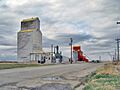
Nobleford's now demolished grain elevators
|
|
| Motto(s):
Home of the Noble Blade
|
|

Nobleford
Location in Alberta
|
|
| Country | Canada |
| Province | Alberta |
| Region | Southern Alberta |
| Census Division | No. 2 |
| Municipal district | Lethbridge County |
| Founded | 1909 |
| Incorporated | |
| • Village | February 28, 1918 |
| • Town | February 28, 2018 |
| Area
(2021)
|
|
| • Land | 1.69 km2 (0.65 sq mi) |
| Elevation | 985 m (3,232 ft) |
| Population
(2021)
|
|
| • Total | 1,438 |
| • Density | 848.6/km2 (2,198/sq mi) |
| Time zone | UTC−7 (MST) |
| • Summer (DST) | UTC−6 (MDT) |
| Highways | 23 519 |
Nobleford is a small town in southern Alberta, Canada. It's about 32 kilometers (20 miles) northwest of the City of Lethbridge. Many people who live in Nobleford travel to Lethbridge for work or school, making it a "bedroom community" – a place where people sleep but often work elsewhere.
Contents
History of Nobleford
How Nobleford Started
The area was first settled in 1909 and called Noble. It was named after Charles S. Noble. He owned a lot of land there and helped build many of the first buildings. In 1910, Charles Noble and his family moved to the area.
Becoming a Village and Town
In 1913, the name was changed to Nobleford. This was to avoid confusion with another community in Ontario. On February 28, 1918, Nobleford officially became a village. Charles Noble was its first mayor. Exactly one hundred years later, on February 28, 2018, Nobleford became a town.
The Noble Blade Factory
From the 1930s until 1998, a big employer in Nobleford was a factory. It was started by Charles Noble and made farm equipment called the Noble blade. This special plow was designed to cut weed roots underground. It helped farmers keep the soil from drying out in Alberta's windy climate.
People and Population
How Many People Live Here?
Nobleford has grown quite a bit over the years! In the 2021 Census, 1,438 people lived in Nobleford. This was a good increase from 1,278 people in 2016. The town covers about 1.69 square kilometers (0.65 square miles). This means there are about 848 people living in each square kilometer.
Getting Around Nobleford
Nobleford is easy to reach by car. It is located right on Highway 519. This highway is just east of Highway 23. The town also has train service.
Education in Nobleford
Noble Central School
Kids in Nobleford go to Noble Central School. This public school teaches students from kindergarten all the way to grade 12. It opened in 1949 and has about 15 teachers. The school provides education for children in the town and the farms nearby.
Fun Things to Do
Community Complex Activities
The Community Complex is a popular spot for fun in Nobleford. It has a curling rink, a big meeting room, and an auditorium. People use it for dances, weddings, and different sports events.
Outdoor Fun Spots
Nobleford also has lots of outdoor places to play. You can find three baseball diamonds and two soccer fields. There's also a climbing wall, a tennis court, and a skating rink. For skateboarders, there's a skate park. You can also enjoy a picnic shelter and barbecue area.
Keho Lake Adventures
Nearby Keho Lake is a great place for outdoor activities. It's very popular for windsurfing and kiteboarding. The lake is also important for farmers, as it stores water for their crops. If you like fishing, you can catch northern pike, walleye, and burbot there. Next to the lake, there's a nine-hole golf course.
Images for kids
-
Nobleford's now demolished grain elevators
