
Billings County, North Dakota facts for kids
Quick facts for kids
Billings County
|
|
|---|---|

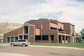
Billings County Courthouse in Medora, North Dakota
|
|

Location within the U.S. state of North Dakota
|
|
 North Dakota's location within the U.S. |
|
| Country | |
| State | |
| Founded | February 10, 1879 (created) May 4, 1886 (organized) |
| Named for | Frederick H. Billings |
| Seat | Medora |
| Largest city | Medora |
| Area | |
| • Total | 1,153 sq mi (2,990 km2) |
| • Land | 1,149 sq mi (2,980 km2) |
| • Water | 4.6 sq mi (12 km2) 0.4% |
| Population
(2020)
|
|
| • Total | 945 |
| • Estimate
(2022)
|
1,018 |
| • Density | 0.8196/sq mi (0.31645/km2) |
| Time zone | UTC−7 (Mountain) |
| • Summer (DST) | UTC−6 (MDT) |
| Congressional district | At-large |
Billings County is a county in the state of North Dakota. In 2020, about 945 people lived there. This makes it the second smallest county in North Dakota by population. The main town and county seat is Medora.
The county was officially created on February 10, 1879. It was named after Frederick H. Billings. He was the president of the Northern Pacific Railway. The county officially started operating on May 4, 1886. Over the years, the county's borders changed many times. Some parts were used to create new counties. These new counties included Bowman County in 1907. Golden Valley County was formed in 1912. Slope County was formed in 1914.
Contents
Geography of Billings County
The Little Missouri River flows through the western part of the county. It flows towards the north. Bullion Creek also flows into the Little Missouri River.
The western part of Billings County has rugged, dry hills. The eastern part has flatter land. The highest point in the county is about 2,523 feet (769 meters) above sea level. This high point is along the western border.
Billings County covers a total area of 1,153 square miles (2,986 square kilometers). Most of this area, 1,149 square miles (2,976 square kilometers), is land. Only a small part, 4.6 square miles (12 square kilometers), is water. The South Unit of Theodore Roosevelt National Park is in the middle of the county. It is just north of Medora.
Main Roads
 Interstate 94
 U.S. Highway 85
Neighboring Counties
- McKenzie County – north
- Dunn County – northeast
- Stark County – east
- Slope County – south
- Golden Valley County – west
Protected Natural Areas
- Little Missouri National Grassland (part of it)
- Rough Rider State Park
- Theodore Roosevelt National Park (South Unit)
People of Billings County
In 2020, the county had 945 people living there. This was counted during the census.
In 2010, there were 783 people in the county. There were 358 households and 223 families. Most people were white (98.6%). A small number were Asian or American Indian. The average age of people in the county was 48.6 years old.
Fun Things to Do
The Bully Pulpit Golf Course is a great place to play golf. It is located three miles south of Medora. The Maah Daah Hey Trail is a long trail for biking and hiking. It starts 30 miles south of Medora.
Towns and Areas
City
- Medora (This is the county seat, or main town)
Unorganized Territories
Billings County does not have townships. Instead, it has two "unorganized territories." These are areas that do not have their own local government.
- North Billings is the area north of I-94. In 2020, 566 people lived there.
- South Billings is the area south of I-94, not including Medora. In 2020, 258 people lived there.
Other Small Communities
Images for kids
-
Billings County Courthouse in Medora, North Dakota
See also
 In Spanish: Condado de Billings para niños
