North Coast Roadside Rest Areas facts for kids
Quick facts for kids North Coast Roadside Rest Areas |
|
|---|---|

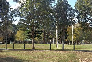
Grassed area, Petrie Road Rest Area, 2016
|
|
| Location | Gympie Road, Petrie, Moreton Bay Region; Steve Irwin Way, Glenview, Sunshine Coast Region; Nambour Connection Road, Woombye, Sunshine Coast Region, all in Queensland, Australia |
| Official name: North Coast Roadside Rest Areas, Petrie Road Rest Area, Jowarra Road Rest Area, Paynter's Creek Rest Area, Wyllie Park | |
| Type | state heritage (landscape, built) |
| Designated | 5 February 2009 |
| Reference no. | 602698 |
| Significant period | Post-war mass motoring |
| Lua error in Module:Location_map at line 420: attempt to index field 'wikibase' (a nil value). | |
The North Coast Roadside Rest Areas are three special places in Queensland, Australia. They are like parks where people can stop and rest during a long drive. These rest areas are very old and important, so they are protected as "heritage-listed" sites.
The three rest areas are:
- Petrie Road Rest Area (also called Wyllie Park) in Petrie (27°16′22″S 152°58′49″E / 27.2728°S 152.9804°E)
- Jowarra Road Rest Area in Glenview (26°46′25″S 153°02′16″E / 26.7735°S 153.0379°E)
- Paynter's Creek Rest Area in Woombye (26°39′20″S 152°58′04″E / 26.6556°S 152.9679°E)
These rest areas were added to the Queensland Heritage Register on 5 February 2009. This means they are recognized for their historical importance.
Why Are These Rest Areas Special?
These rest areas were built by the Main Roads Commission (MRC) starting in the early 1950s. They were placed along the old Bruce Highway and other important roads. They show how travel and tourism changed in Queensland after World War II.
The Rise of Cars
In the early 1920s, more and more people in Queensland started owning cars. In 1921, about 8,000 cars were registered. By 1923, this number grew to nearly 17,000. At first, only rich people owned cars. But as cars became more common, there was a big need for better roads.
The Queensland Government created the Queensland Main Roads Board in 1920. Before this, local councils had to pay for roads, but they often didn't have enough money or skills. The new Board worked with councils to build and maintain roads. Their first goal was to build roads that connected to railway lines and helped new towns grow.
Roads and Tourism
Better roads helped tourism grow, especially along the North Coast, which is now called the Sunshine Coast. In the 1920s, several key roads were built with help from Main Roads. These included roads to Maleny, Montville, and coastal towns like Maroochydore and Caloundra.
The Bruce Highway was a very important road. The first part of it, between Rothwell and Eumundi, opened in December 1934. By then, there were almost 92,000 vehicles in Queensland. The highway was first called a "tourist" road. It helped seaside resorts like Maroochydore and Caloundra become very popular.
Building the Bruce Highway
People wanted the Bruce Highway to connect northern and southern Queensland. But the government thought railways were enough for travelers. Slowly, the highway grew longer. By 1942, the road between Brisbane and Eumundi was covered in bitumen.
During World War II, road building slowed down. Main Roads focused on roads for defence. After the war ended in 1945, it took a few years for road work to pick up again. By 1962, the Bruce Highway was fully bitumen-sealed all the way from Brisbane to Cairns.
Why Rest Areas Became Important
In the 1950s, more people could afford cars. Petrol rationing ended, and people had longer paid holidays. This led to a huge increase in car tourism. Australia became one of the top countries for car ownership. In Queensland, car ownership jumped from 100,000 to over 240,000 between 1950 and 1960.
Because so many people were driving, "off the road" areas, or rest areas, became very important. These places allowed drivers to stop, rest, and relax. Early guides for the North Coast listed rest areas at Petrie, Burpengary Creek, and Paynter's Creek.
In 1952, Main Roads said that rest areas were "much appreciated" by drivers. They also started planting trees along roads and at rest areas. This showed that Main Roads wanted to make journeys better, not just build roads.
Growing Popularity
Rest areas became even more popular in 1953. Drivers wrote letters to thank Main Roads for providing them. The areas were meant for daytime use. But some people started using them for overnight camping.
Many rest areas had concrete or stone fireplaces. These allowed travelers to "boil the billy" (make tea) safely. Parks near Brisbane, like Petrie Park, were very busy. One Sunday, 192 cars were counted at Petrie Park.
By 1955, Main Roads noted that rest areas were "extremely" popular. They were especially liked by people traveling long distances. The report said that drivers used the areas to take breaks in hot weather. This helped them drive better and reduced accidents. It also meant fewer bushfires from makeshift roadside fires.
What Rest Areas Offered
The facilities at rest areas depended on their size. Smaller areas had a table, seats, and a fireplace. Larger areas offered tables and seats, sometimes under "rustic" shelters. They also had water tanks, rubbish bins, and toilets. Many areas were planted with trees to make them more attractive.
Rest areas quickly became popular for caravan tourists. Caravans started appearing more often in the 1950s. Not many places had special facilities for caravans back then. So, rest areas became important places for caravanners to stop. Paynter's Creek and Pine River rest areas were used by caravanners.
By 1955, so many caravans were using certain rest areas that Main Roads limited stays to 48 hours. This made sure there was space for everyone.
Keeping Rest Areas Maintained
Because rest areas were used so much, they needed constant care. Main Roads crews and local councils helped maintain them. In 1954, Paynter's Creek had toilets, rubbish bins, and new trees.
Between 1957 and 1970, the Bruce Highway between Brisbane and Nambour was rebuilt. Traffic increased a lot during this time. New bridges and road sections were built. By the 1970s, the Bruce Highway was mainly for through traffic heading north.
By 1971, Queensland had 130 Main Roads rest areas. They started upgrading these areas. They wanted new structures and more sites. They decided that rest areas should be at least three acres in size. The most important facilities were septic toilets, water, and covered rubbish bins.
Upgrades continued through the 1970s and early 1980s. Main Roads wanted to make rest areas good enough to encourage drivers to stop. The 48-hour stay limit remained in 1980. Main Roads also started giving out brochures with rest area locations and facilities.
Modern Changes
Between 1980 and the mid-1990s, parts of the old Bruce Highway were replaced. New sections bypassed towns like Nambour and Cooroy. The older parts of the highway became "tourist drives."
Today, service station food courts and "Driver Reviver" stops offer breaks on the current Bruce Highway. But the old rest areas are still popular. Even though their facilities have been updated, their purpose is the same. They offer drivers a nice, park-like place to rest. This helps reduce tired driving accidents and makes travel more enjoyable.
In 2008, only the Petrie, Matthew Flinders, Jowarra, and Paynter's Creek rest areas were left. The Matthew Flinders rest area was later removed for a railway project.
What Do They Look Like?
Petrie Rest Area
The Petrie Road Rest Area is a wooded park in Petrie. It's shaped like a triangle. Gympie Road is on one side, the North Coast railway line on another, and the North Pine River on the third. You can enter from Gympie Road.
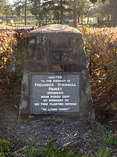
Two tall green wooden posts mark the entrance. A bitumen road with wooden posts loops through the park. Near the entrance, there's a granite monument for Frederick Stanwell Parkes, an engineer.
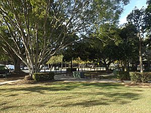
The road goes around a garden with a shelter, barbeque, and playground. There are tables and seats next to the electric barbeque. The playground is nearby. The shelter is shaped like a hexagon.
The northern part of the park is for campers and caravans. It's a grassy area with lots of trees. There's also a cream-colored toilet block.
The southern part of the park is a big, grassy area with some trees. You'll find picnic spots and another shelter here. Concrete paths run through this area, and one path crosses a small wooden bridge over a gully.
Jowarra Rest Area
The Jowarra Road Rest Area is next to Steve Irwin Way, south of the Bruce Highway's Caloundra Road exit. It's near the Beerwah Forest Reserve. An access road runs next to Steve Irwin Way. It leads to a paved car park for about 50 vehicles and a gravel area for 9 vans. There are also parking spots along the access road. A sign says "maximum stay 20 hours" for vans.
This park has tall, old trees that provide lots of shade. The grassy area between the car park and the van area has a picnic shelter, a toilet block, a concrete water tank, and picnic tables. It's also the entrance to the Jowarra Walking Tracks.
The picnic shelter has stone walls and a metal roof. A timber sign on the roof says "MRD Jowarra Park 1960." Inside, there are modern picnic tables. An information board about the Great North Road is nearby.
The entrance to the walking tracks has two stone pillars. Another information board with a small roof is also close by.
Paynter's Creek Rest Area
Paynter's Creek Road Rest Area is a long, narrow park with many old trees. It's located below the west side of Nambour Connection Road, about three kilometers south of Nambour. Cobbs Road is to the north, a private property to the west, and Paynter Creek to the south. You can get into the park from Cobbs Road.
A paved road with timber posts forms a U-shape through the park. Grassy areas in the middle and along the road have wooden picnic tables and seats. One set of tables is under a gabled roof. There's a quiet camping area and a car parking area off the internal road.
Why Are They Heritage Listed?
The North Coast Roadside Rest Areas were added to the Queensland Heritage Register on 5 February 2009. This means they are important parts of Queensland's history and culture.
Showing History
These rest areas (Petrie, Jowarra, and Paynter's Creek) were built between 1951 and 1960. They are some of the oldest rest areas on what was then Queensland's most important tourist road. They show how Queensland's road network and tourism changed. In the early 1950s, more people started taking long car trips. These rest areas were built to help these travelers.
The rest areas also show the early days of caravanning. When caravans became popular in the 1950s, there weren't many places for them to stop. So, these rest areas became important short-term spots for caravanners.
Showing Key Features
Petrie, Jowarra, and Paynter's Creek rest areas are great examples of this type of place. They were designed for travelers to stop, eat, and rest. They are easy to reach from the road and have parking for vehicles. They also offer picnic tables and barbeque facilities. Petrie and Jowarra also have camping spots, van parking, and toilets.
Aesthetic Value
These rest areas are valued for their beauty and peacefulness. They are shady, calm places where travelers can relax. They offer a chance to enjoy picnics and other fun activities in a pleasant outdoor setting.
 | William L. Dawson |
 | W. E. B. Du Bois |
 | Harry Belafonte |


