North Fork American River facts for kids
Quick facts for kids North Fork American River |
|
|---|---|

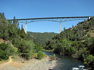
Foresthill Bridge over the North Fork
|
|

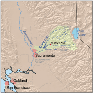
Map of the American River watershed including the North Fork
|
|
| Country | United States |
| State | California |
| Physical characteristics | |
| Main source | Mountain Meadow Lake Sierra Nevada, Placer County 7,935 ft (2,419 m) 39°13′04″N 120°16′28″W / 39.21778°N 120.27444°W |
| River mouth | Folsom Lake Auburn, Placer County 469 ft (143 m) 38°42′42″N 121°08′44″W / 38.71167°N 121.14556°W |
| Length | 88 mi (142 km) |
| Basin features | |
| Basin size | 996 sq mi (2,580 km2) |
The North Fork American River is the longest branch of the American River in Northern California. It stretches about 88 miles (142 km) from its starting point high in the Sierra Nevada mountains to where it joins Folsom Lake. This lake is located northeast of Sacramento. Before the Folsom Dam was built, the river was even longer, reaching about 97 miles (156 km).
Contents
Journey of the North Fork American River
The North Fork American River begins at Mountain Meadow Lake. This lake is found near the 9,008 ft (2,746 m) peak of Granite Chief in the Tahoe National Forest.
From Mountains to Foothills
When the river first starts, it flows towards the northwest. Soon, it turns west and carves a deep valley or gorge. This gorge runs alongside an area called the Forest Hill Divide. A stream named Big Granite Creek then joins the North Fork from the right side.
As the river continues, the canyon becomes less deep. The river then turns southwest, cutting through the lower hills of the Sierra Nevada. It makes a sharp turn south near the town of Colfax.
Meeting Lake Clementine
About 4 miles (6.4 km) downstream from Colfax, another stream called Shirttail Creek flows into the North Fork from the left. After this, the river flows into Lake Clementine. This lake is also known as North Fork Lake. It was created by the North Fork Dam, which was built in 1939. The dam was originally built to hold back dirt and rocks from an old mining method called hydraulic mining.
Flowing into Folsom Lake
Below the North Fork Dam, the river bends south again. It passes under the Foresthill Bridge, which is the tallest bridge in California. Then, the Middle Fork American River, the largest stream that feeds into the North Fork, joins it from the left.
The valley around the river gets wider as it flows south past the city of Auburn. Soon after Auburn, the North Fork empties into the northern part of Folsom Lake. This large reservoir was formed in 1955 by the Folsom Dam. The waters of the North Fork mix with those from the South Fork American River in Folsom Lake. Together, they form the main American River, which then flows into the Sacramento River.
External links
- North Fork American Wild and Scenic River - BLM page
 | Kyle Baker |
 | Joseph Yoakum |
 | Laura Wheeler Waring |
 | Henry Ossawa Tanner |

