
Middle Fork American River facts for kids
Quick facts for kids Middle Fork American River |
|
|---|---|

Middle Fork flowing through the Auburn State Recreation Area
|
|

Map of the American River drainage basin
|
|
| Country | United States |
| State | California |
| Physical characteristics | |
| Main source | Granite Chief Wilderness Placer County 8,382 ft (2,555 m) 39°11′39″N 120°16′49″W / 39.19417°N 120.28028°W |
| River mouth | North Fork American River near Auburn 538 ft (164 m) 38°54′55″N 121°02′14″W / 38.91528°N 121.03722°W |
| Length | 62.3 mi (100.3 km) |
| Basin features | |
| Basin size | 616 sq mi (1,600 km2) |
| Tributaries |
|
The Middle Fork American River is one of three main branches that form the American River in Northern California. It flows through a large area in the high Sierra Nevada mountains. This river is located west of Lake Tahoe and northeast of Sacramento. It runs through Placer and El Dorado Counties. The Middle Fork is found between the North Fork American River and South Fork American River. It joins the North Fork near Auburn. Even though the Middle Fork carries more water, the river continues downstream to Folsom Lake as the North Fork.
The Middle Fork was a very rich area for gold mining in the 1850s. People still search for gold here today as a hobby. The river has many dams. These dams are used to create hydroelectricity (power from water) and provide drinking water. While some parts of the Middle Fork have less water due to these diversions, the section in the Auburn State Recreation Area is popular for whitewater rafting. The Middle Fork canyon also has many trails for hiking and riding. One famous trail is the Western States Trail, which is 100 miles (160 km) long and goes from Auburn to Lake Tahoe.
Contents
Where Does the Middle Fork American River Flow?
The Middle Fork starts from a spring in the Granite Chief Wilderness. This is in eastern Placer County, west of the Squaw Valley Ski Resort. The starting point is 8,382 ft (2,555 m) above sea level, about 10 miles (16 km) west of Lake Tahoe. The river's beginnings are in a rocky area with many small streams. One stream flows from Little Needle Lake. The river flows west, then turns southwest after Talbot Creek joins it. It passes through the French Meadows valley. You can find several campgrounds and trails along this upper part of the river.
About 12 miles (19 km) from its source, the river reaches French Meadows Reservoir. This reservoir is 5,223 ft (1,592 m) above sea level. It was formed by the L.L. Anderson Dam. Most of the river's water here is sent away to make electricity. This means the river right below the dam becomes very small, almost a trickle, unless there's a lot of snow melting.
Below Anderson Dam, the Middle Fork forms the border between the Tahoe National Forest to the north and the Eldorado National Forest to the south. This continues almost all the way to where it meets the North Fork. The river turns south-southwest and flows through a very steep canyon. It drops about 1,600-foot (490 m) in 10 miles (16 km). It then meets Duncan Creek at 3,379 ft (1,030 m) above sea level. The Middle Fork's canyons are often more than 2,000 ft (610 m) deep. They are surrounded by high ridges like Red Star and Chipmunk Ridges.
From Duncan Creek, the Middle Fork turns west. It winds through its rugged canyon and flows into the small Interbay Reservoir. Here, more water is taken out for power. Big Mosquito Creek joins from the right. The river then makes a big curve around Tanner Point. The Middle Fork continues west towards Ralston Ridge. Here, its largest branch, the Rubicon River, joins it. The Rubicon River is actually longer than the Middle Fork above their meeting point. Its drainage area is also larger. Like the upper Middle Fork, most of the Rubicon's water is used to make power. This water returns to the Middle Fork at Ralston Afterbay (Oxbow Reservoir). This is right below where the Middle Fork and Rubicon River meet, at 1,168 ft (356 m) elevation.
A short distance below the dam, the Middle Fork is joined by its second largest branch. This is the North Fork Middle Fork American River. This branch drains a large area along the Forest Hill Divide. The North Fork Middle Fork flows freely, without any major dams or diversions. Just downstream, the Middle Fork flows through Tunnel Chute. Here, the river rushes through a tunnel that was blasted out during the California Gold Rush. This was done to dry out part of the riverbed for mining. The Middle Fork marks the border between Placer County (north) and El Dorado County (south) from Oxbow Dam until it meets the North Fork.
Near Foresthill, the Middle Fork leaves the national forests. It enters the Auburn State Recreation Area in the Sierra Nevada foothills. Its canyon becomes wider, less steep, and covered in thick forests. The canyon is about 1,000 to 1,500 ft (300 to 460 m) deep from the top to the river. Many smaller creeks and canyons join it here. These include Volcano Canyon, Otter Creek, and Canyon Creek. Even though the river flows less steeply here, its most dangerous rapid is Ruck-A-Chucky Falls. This is just north of Greenwood. Below Ruck-A-Chucky, the Middle Fork turns sharply south. Then it turns west-southwest again, joining the North Fork at "The Confluence." This meeting point is at 538 ft (164 m) elevation. It's just east of Auburn, below the Foresthill Bridge.
What is the Middle Fork American River Watershed Like?

The Middle Fork American River watershed covers 616 square miles (1,600 km2). This is about one-third of the entire American River drainage basin above Folsom Lake. The Rubicon River has the largest tributary watershed, at 315.4 sq mi (817 km2). This is almost three times bigger than the Middle Fork's own area above where they meet. Most of the watershed is covered in forests. The highest parts near the Sierra Crest are alpine (like mountains above the tree line). Some areas in the foothills have grasslands and shrubs.
The land ranges from 538 ft (164 m) at the river's mouth to over 9,900 ft (3,000 m) at the Rubicon River's source. More than half of the watershed is 5,000 ft (1,500 m) or higher. The land is very rugged, with thin, rocky soils. This means there's a high risk of erosion. Water generally flows southwest between long, parallel ridges. The Forest Hill Divide forms the northern border of the watershed. Major ridges to the south include Deadwood, Mosquito, Red Star, Ralston/Chipmunk, and Nevada Point Ridges. The only exception is the Rubicon River's source, which flows northwest before turning southwest.
Few people live in the watershed. The biggest towns are Georgetown and Foresthill. In 2010, Georgetown had 2,367 people, and Foresthill had 1,483. There are also smaller communities like Todd Valley, Michigan Bluff, and Volcanoville. All of these started as mining camps during the Gold Rush. The closest large city is Auburn, with about 13,000 people. It's one of the northernmost communities in the Sacramento metropolitan area. About 75 percent of the watershed is managed by the U.S. Forest Service. The rest is split between the U.S. Bureau of Land Management, the state of California, and private landowners. In the lower part of the watershed, about half the land is privately owned. It is used for homes and some logging.
The Middle Fork watershed gets a lot of rain and snow. It averages 50 inches (1,300 mm) of precipitation each year. This can range from 40 to 70 inches (1,000 to 1,800 mm) from the foothills to the mountains. Since the area has a Mediterranean climate, most of the rain and snow falls between November and March. At elevations higher than 5,000 ft (1,500 m), most precipitation is snow. Areas above 6,000 ft (1,800 m) often have snow until late May or early June. Water flow in the upper Middle Fork and Rubicon Rivers comes mostly from melting snow. The North Fork Middle Fork is affected by both snowmelt and rainfall. Tributaries of the lower Middle Fork depend mostly on rainfall.
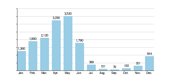
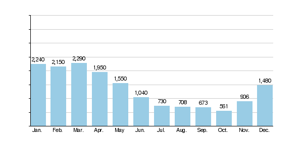
Dams and diversions have greatly changed the water flow in the Middle Fork. High flows in late spring and early summer are stored in reservoirs. This water is used to make hydropower later in the year when natural water levels are low. The charts below show how dams have changed the river's monthly flow. French Meadows and Hell Hole reservoirs were built in 1964 and 1996.
Middle Fork monthly mean discharge at Auburn, 1911–1966 (cfs)
Middle Fork monthly mean discharge at Auburn, 1966–1986 (cfs)
Plants and Animals of the Middle Fork
The Middle Fork watershed has many different types of plant life. A study in 2011 found five main forest types in the upper Middle Fork area.
- Mixed conifer forests make up 51 percent of the area. These are mostly found below 5,000 feet (1,500 m). They include trees like ponderosa pine, sugar pine, Jeffrey pine, incense-cedar, white fir, Douglas fir, black oak, and live oak. Some of these are hardwood-conifer forests, with more oaks.
- White fir forests are the second largest group, covering about 22 percent.
- Red fir forests cover about 13 percent, mostly at higher elevations.
- Hardwood forests cover about 11 percent at lower elevations, often on hillsides.
- Some south-facing slopes at lower elevations have chaparral (dense shrubs) and grasslands.
The Placer County Grove is a special place. It's just northwest of where the Middle Fork and Duncan Creek meet. This grove has the northernmost giant sequoia trees in California. There are six trees, believed to be 1,000 to 2,000 years old. The Joffre Tree is the tallest, standing 250 feet (76 m) high.
.jpg)
For a long time, fires have been stopped in these forests. This has caused white fir trees to grow more, while some pines, like yellow pine and sugar pine, have decreased. There's now more "fuel" (dead plants and wood) in the forests. This means when fires do happen, they are bigger and more intense. Human activities have also affected the plant life. These include grazing animals, mining, building roads, and cutting down large trees.
The riparian habitat (plants along the river banks) is limited along the Middle Fork. This is because of the rocky ground, a lot of sediment, and frequent floods that clear out the river channel. However, many smaller streams that flow into the Middle Fork have healthy riparian zones. The Middle Fork is generally a wide river with a gravel bottom. It has a mix of shallow, fast-moving areas (riffles) and deeper, slower areas (pools). The water quality is generally good. However, dams and water diversions have reduced places for fish to lay their eggs.
The Middle Fork is home to many fish species. You can find rainbow trout, brown trout, Sacramento sucker, and Sacramento pikeminnow along the whole river. Smallmouth bass live in most of the main reservoirs and lakes. Fish found only in the lower parts of the river include hardhead, riffle sculpin, and prickly sculpin. At higher elevations, you can find brook trout. Cutthroat trout, lake trout, and kokanee salmon also live at higher elevations. They have only been seen in Hell Hole Reservoir and the Rubicon River upstream from there.
Many other wild animals live along the Middle Fork. These include deer, black bears, mountain lions, bobcats, river otters, golden eagles, and bald eagles. More than 20 species that are endangered, threatened, or sensitive have been found here. These include the Sierra Nevada yellow-legged frog, California red-legged frog, and California spotted owl.
How Has the Middle Fork American River Been Used by People?

The Middle Fork canyon was first home to the Nisenan people. Their land covered much of the American and lower Feather River areas. This stretched from the Sacramento River east into the western Sierra Nevada. The Washoe people lived east of the Sierra Crest. But they sometimes came into the high parts of the Middle Fork to hunt in summer. The Nisenan had permanent homes on the ridges above the Middle Fork, especially along the Forest Hill and Georgetown Divides. They gathered plants at lower elevations. Their main food was black oak acorns. They also used many native grasses, roots, herbs, seeds, and berries. They used controlled fires to clear brush. This helped with hunting and oak growth. The Middle Fork and Rubicon River canyons were important travel routes for summer hunting in the high Sierra. Besides animals like deer, quail, and rabbits, the rivers were a major food source. Salmon would migrate up the rivers in spring and fall.
Europeans likely first explored the upper American River area in 1827. This was during Jedediah Smith's expedition. After gold was found on the South Fork American River in 1848, miners quickly came to the Middle and North Forks. Less than two years later, almost 10,000 miners had claimed land on the Middle Fork. Some of the richest spots were Ford's Bar, Maine Bar, Murderer's Bar, and Spanish Bar. In the 1850s, the "Grand Flume" was built along the Middle Fork. This diverted water from a 6-mile (9.7 km) section of the riverbed. This allowed miners to dig for gold in the dry riverbed. North of the Middle Fork, the Michigan Bluff to Last Chance Trail was built. This was a "toll trail" used by mules carrying supplies to mining camps.
In 1850, miners blasted a tunnel through a ridge. This diverted the Middle Fork away from a long bend called Horseshoe Bar. This allowed them to mine the riverbed for gold. This was the first mining tunnel in California. Over time, the river dug its own bed deeper. This exposed a rock ledge that blocked the tunnel. The river then flowed back through the old bend. To force the river back into the tunnel, a narrow channel was blasted through the ledge. This created the difficult rapid known as Tunnel Chute. Horseshoe Bar was one of the richest gold spots on the Middle Fork. About $2.5 million in gold was taken from just 1.5 miles (2.4 km) of riverbed. The Middle Fork was one of the richest gold-bearing streams in the Mother Lode region. A report from 1890 estimated that about $1 million of placer gold was found per mile from 1849 to 1863. The Middle Fork continued to produce a lot of gold into the 1880s. This was more than 20 years after most nearby streams were exhausted.
Miners exploring the side canyons found that the gold-bearing gravels came from about 2,000 ft (610 m) above the river. These gravels were actually old riverbeds from millions of years ago. Over time, these old beds eroded, creating the gold deposits in the modern river. Hydraulic mining (using powerful water jets) and hard-rock mining (digging into rock) spread along the Middle Fork canyon. Georgetown, founded in 1849, became a center for this mining. Mines in Georgetown and other camps were high above the river. So, they couldn't use water directly from the Middle Fork. They built many flumes and ditch systems to bring water from smaller streams. The California Water Company operated many hydraulic mines. By 1874, they owned 300 miles (480 km) of ditches, flumes, and pipes. Much of this water came from Pilot Creek, a branch of the Rubicon River. Many of these ditches were abandoned after the Gold Rush. But some are still used for irrigation, and others have become hiking trails.
Mining greatly impacted the Middle Fork and beyond. Entire hillsides, loosened by hydraulic mining, slid into the river. They were then carried into the Sacramento Valley during winter floods. This damage to river navigation and flood control led the state to ban hydraulic mining in 1884. But sediment continued to flow. A debris dam to hold sediment on the Middle Fork was first considered in 1891. By 1900, an estimated 10 to 15 million cubic yards (7.6–11.5 million m3) of sediment had built up in the Middle Fork. In 1935, the U.S. Army Corps of Engineers was allowed to build dams in the American River basin to trap sediment. The North Fork was dammed in 1938–39 to form Lake Clementine. On the Middle Fork, the Army Corps started building the Ruck-a-Chucky dam. But work stopped in 1940 due to landslides. The start of World War II further delayed this project.

In 1906, John C. Hawver, a dentist, found large limestone caves along the lower Middle Fork canyon. These caves were about 700 feet (210 m) above the river. About 400 specimens were taken from the site. These included fossils of saber-toothed tigers, mastodons, and giant ground sloths. They also found human remains from the Ice Age. Many of these are now at the University of California, Berkeley. By 1912, the Pacific Portland Cement Company operated a limestone quarry nearby. The 7-mile (11 km) Mountain Quarries Railroad ran through the lower Middle Fork and North Fork canyons. It connected to the Southern Pacific main line south of Auburn. To reach the quarry, a tunnel was dug under the cave system near the river. The cave itself was left untouched. The railroad was abandoned in 1939. But most of its path, including the famous Mountain Quarries Bridge ("No Hands Bridge"), is now part of the Western States Trail. In the early 2000s, Hawver Cave was blocked off due to repeated vandalism.
In 1863, William Brewer crossed the Sierra Nevada using the Middle Fork and Squaw Valley. This was something Jedediah Smith had tried and failed to do earlier. The old Native American trail Brewer followed was later used by some miners during the silver boom in Nevada. But it was too rugged and lacked water, so it didn't become a major crossing. This route, which included the Michigan Bluff to Last Chance Trail, an old mining ditch path, and the Mountain Quarries Railroad path, became known as the Western States Trail. This 100-mile (160 km) long trail gained new attention in 1955. Wendell T. Robie and friends rode its entire length from Squaw Valley to Auburn in one day. Robie helped start the Western States Trail Ride, now known as the Tevis Cup. This is an annual endurance ride along this course. Part of the trail in the Auburn State Recreation Area is named the Wendell T. Robie Trail. In 1974, Gordon Ainsleigh ran the course in 24 hours. The first Western States Endurance Run was held in 1977.
The Middle Fork Project was built by the Placer County Water Agency (PCWA). It provides water and hydropower. It was approved in 1963. L.L. Anderson (French Meadows) Dam, finished in 1964, was the first big structure. Hell Hole Dam on the Rubicon River was still being built when a huge flood hit northern California. More than 22 inches (560 mm) of rain fell in five days. On December 23, the unfinished dam was destroyed by the water. A 60-foot (18 m) wall of water rushed down the Rubicon and Middle Fork canyons. It caused landslides, uprooted trees, and destroyed buildings and bridges. However, no one lived permanently in the canyon, so no lives were lost. The floodwaters were held back by Folsom Lake, saving Sacramento from damage. The flood surge of 260,000 cubic feet per second (7,400 m3/s) might have been bigger than any natural flood since the Pleistocene Ice Age. The dam was rebuilt and finished in 1966.
In 1965, the U.S. Bureau of Reclamation was allowed to build the Auburn Dam. This dam would have flooded parts of the North and Middle Forks for about 40 miles (64 km). It would have covered most of the Auburn State Recreation Area. It would have submerged parts of the Western States Trail, American Canyon, and Ruck-a-Chucky Falls. During early work on the dam, a unique curved bridge was planned to cross the Middle Fork arm of the reservoir. Instead of using support piers, the bridge cables would have been anchored directly to the canyon walls. But due to worries about earthquakes and strong public opposition, Auburn Dam was never finished. The bridge project also ended.
How is the Middle Fork American River Modified?

The Middle Fork has dams in its upper parts as part of the Middle Fork Project (MFP). The Placer County Water Agency (PCWA) runs this project. It provides drinking water and power to communities like Auburn and Roseville. The project makes about 1,030,000 megawatt hours (MWh) of electricity each year. It uses 452,000 acre-feet (558,000 ML) of water from the Middle Fork and Rubicon rivers. There are five powerhouses that can produce 224 megawatts (MW) of power. The most power made in one year was 1,815,000 MWh in 1983. The least was 211,000 MWh in 1977. All the electricity goes to Pacific Gas & Electric Company.
French Meadows Reservoir is the highest reservoir in the MFP. It holds up to 134,993 acre-feet (166,511 ML) of water from the upper Middle Fork. This water is sent through the French Meadows-Hell Hole Tunnel to Hell Hole Reservoir. Hell Hole Reservoir holds 207,590 acre-feet (256,060 ML) of water from the Rubicon River. Almost all the water from both the Middle Fork and Rubicon Rivers, except for a small amount released for fish, goes through the Hell Hole–Middle Fork Tunnel. At the end of this tunnel, water drops 1,479 ft (451 m) to the Middle Fork Powerhouse. This powerhouse makes 122.4 MW of power. It is located at Interbay Reservoir, about 15 miles (24 km) downstream from French Meadows.
Interbay Reservoir collects water from smaller streams that join the Middle Fork below French Meadows. This water, along with water from Hell Hole, goes into the Middle Fork-Ralston Tunnel. It then drops another 1,105 ft (337 m) to the Ralston Powerhouse. This powerhouse makes 79.2 MW of power. It is located at Oxbow Reservoir, where the Middle Fork and Rubicon Rivers meet. Oxbow Reservoir (Ralston Afterbay) helps control the water flow. It allows the power plants to make electricity when needed, while releasing a steady flow downstream. Besides the two main powerhouses, there are smaller ones below Hell Hole and Ralston Afterbay dams. There are no dams on the Middle Fork below Oxbow.
PCWA has rights to use up to 120,000 acre-feet (150,000 ML) of water from the Middle Fork. As of 2007, it was contracted to deliver 84,000 acre-feet (104,000 ML). Its main customers are the U.S. Bureau of Reclamation, San Juan Water District, the city of Roseville, and the Sacramento Suburban Water District. Water is delivered from the American River Pump Station. PCWA must keep a minimum flow of 75 cu ft/s (2.1 m3/s) below the station at all times. In dry years, the California Department of Water Resources may ask PCWA to release more water to keep flows in the lower American River. However, PCWA thinks that water demand might be higher than its supply before 2057 due to population growth.
The Upper American River Project also diverts a lot of water from the upper Rubicon River. This project is owned by the Sacramento Municipal Utility District. It sends water to a separate hydroelectric system along the South Fork of the American River. It operates several reservoirs in the upper Rubicon area, with Loon Lake being the largest. About 180,000 acre-feet (220,000 ML) of water is diverted from the Rubicon River each year.
Fun Activities on the Middle Fork American River

The Western States Trail is a winding 100-mile (160 km) path. It goes through the canyons of the Middle Fork and its branches from Auburn to Squaw Valley. The first third of the trail, from Auburn to Foresthill, follows the Middle Fork canyon closely. Parts of the trail were built on old mining ditches, so they are fairly flat. East of Foresthill, the trail goes up into the North Fork Middle Fork area. It then rejoins the Middle Fork at the top of Red Star Ridge, overlooking French Meadows Reservoir. It then follows the northern ridge of the Middle Fork valley through the river's source at the Sierra Crest, before reaching Squaw Valley. The trail also connects to the American River Parkway at its western end. This allows hikers and horseback riders to travel all the way from Sacramento. Many other trails lead from the canyon rim down to different spots along the river. About 50 miles (80 km) of the trail has been named a National Recreation Trail.
You can go whitewater rafting on the Middle Fork below Oxbow Reservoir. Thanks to an agreement, water is released year-round for boating, except during very dry periods. Water releases of 1,000 cubic feet per second (28 m3/s) or more usually start at 7:00 am in the summer. They are slowly reduced in the evening. Without the dams, the river flow in late summer would naturally be around 300 cubic feet per second (8.5 m3/s). There are 15 miles (24 km) of Class III–V (intermediate to difficult) rapids and 9 miles (14 km) of Class II (moderate) rapids on this part of the river. The Class VI Ruck-A-Chucky Falls is the most dangerous rapid. It's about halfway between Oxbow Reservoir and the North Fork confluence. All commercial rafting companies and most private boaters carry their boats around it (portage).
The Mammoth Bar OHV Area is next to the river near Auburn. This popular area for motorcycles and ATVs was created in 1993.
The Middle Fork is still a place for recreational gold panning. However, it's not as popular as the South Fork. There are about 400 active mining claims on the Middle Fork. The river is open all year, but using equipment like metal detectors is restricted.
