Folsom Dam facts for kids
- For the settlement formerly called Folsom Dam, see Morgans Landing, California.
Quick facts for kids Folsom Dam |
|
|---|---|
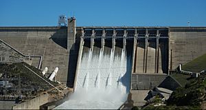
Folsom Dam release
|
|
| Location | Folsom, California |
| Coordinates | 38°42′28″N 121°09′23″W / 38.7077°N 121.1565°W |
| Construction began | 1948 |
| Opening date | 1956 |
| Construction cost | US$81.5 million |
| Operator(s) | U.S. Bureau of Reclamation |
| Dam and spillways | |
| Impounds | American River |
| Height | 340 ft (100 m) |
| Length | 1,400 ft (430 m) |
| Reservoir | |
| Creates | Folsom Lake |
| Total capacity | 977,000 acre⋅ft (1.205 km3) |
| Inactive capacity | 83,000 acre⋅ft (0.102 km3) |
| Catchment area | 1,875 sq mi (4,860 km2) |
| Surface area | 11,930 acres (4,830 ha) |
| Power station | |
| Commission date | 1955 |
| Hydraulic head | 300 ft (91 m) (rated) |
| Turbines | 3x Francis |
| Installed capacity | 198.7 MW |
| Annual generation | 528,427,000 KWh (2001–2012) |
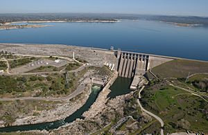
Folsom Dam is a huge concrete dam on the American River in Northern California, United States. It's about 25 miles (40 km) northeast of Sacramento. The dam is 340 feet (104 m) tall and 1,400 feet (427 m) long. It also has long earthen walls on its sides. The dam was finished in 1955 and officially opened in 1956.
The dam sits where the north and south forks of the American River meet. It was built by the United States Army Corps of Engineers. After it was finished, it was handed over to the United States Bureau of Reclamation. The dam and its lake, Folsom Lake, are part of the Central Valley Project. This project helps control floods, makes hydroelectricity (power from water), and provides water for farms and cities.
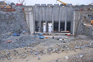
To better protect Sacramento from floods, the U.S. Army Corps of Engineers built an extra spillway. This was finished in October 2017. It helps dam operators release more water when needed. This stops the lake from getting too high. Another dam from the Central Valley Project, Nimbus Dam, is located further down the river.
Contents
How Folsom Dam Works
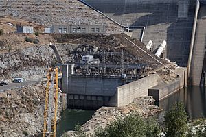
Folsom Dam is just north of the city of Folsom. It's a hollow concrete dam, 340 feet (104 m) high and 1,400 feet (427 m) long. It used 1,170,000 cubic yards (894,500 m³) of material to build. On its sides, there are two long earthen walls called wing dikes. There are also nine smaller dams, called saddle dams, that help hold the lake in place.
The wing dikes are 8,800 feet (2,682 m) long. The saddle dams are 16,530 feet (5,038 m) long combined. All together, the dam and its walls stretch for more than 5 miles (8 km). When there's too much water, floodwaters are released through a spillway. This spillway has eight gates that can let out a lot of water very quickly. There are also other openings that can release more water.
Folsom Lake: The Reservoir
The water held back by the dam forms Folsom Lake. When the lake is full, it can hold 977,000 acre-feet (1.2 km³) of water. It can even hold an extra 110,000 acre-feet (0.14 km³) during floods. The lake used to hold a bit more water, but some space has been lost because of sedimentation (dirt and sand settling at the bottom).
At its highest level, the lake covers 11,930 acres (4,828 ha). It has about 75 miles (121 km) of shoreline. The dam and lake control water from an area of 1,875 square miles (4,856 km²). This is most of the American River watershed. On average, 2,700,000 acre-feet (3.3 km³) of water flow into the lake each year. About 1,700,000 acre-feet (2.1 km³) of this water is released to help control floods.
Making Electricity at Folsom Dam
The Folsom Power Plant is on the north side of the river, at the bottom of the dam. It has three large Francis turbines. These turbines work together to make 198.72 megawatts (MW) of electricity. This is more than the original 162 MW it could make when it first opened.
The power plant usually runs during the day. This is when people need the most electricity, and it costs more. On average, the plant produces 691,358,000 kilowatt hours of electricity every year.
History of Folsom Dam
People first suggested building Folsom Dam in the 1930s. This was part of California's State Water Plan. It was needed because Sacramento often had serious floods. The risk of flooding grew after the 1850s due to hydraulic mining (a type of mining that used powerful water jets) and the building of levees. These changes made the Sacramento and American Rivers less able to handle large amounts of water.
The U.S. Congress first approved the dam in 1944. It was meant to be a 355,000 acre-foot (0.44 km³) flood control project. In 1949, it was approved again as a larger, 1,000,000 acre-foot (1.2 km³) project with many purposes.
Earlier Dam and Construction
The current Folsom Dam replaced an older, smaller dam. That dam was built in 1893 by Horatio Gates Livermore. The older dam powered the Folsom Powerhouse. This powerhouse sent electricity to Sacramento through a 22-mile (35 km) long line. This was the longest electrical distribution system in the world at that time. You can still see parts of the old dam downstream from the Folsom Lake Crossing.
Building the new dam started in 1951. Workers first dug out the area for the Folsom Power Plant. The main building contract was given to Savin Construction Corp. and Merritt-Chapman & Scott. The U.S. Army Corps of Engineers oversaw the work. On October 29, 1952, the first concrete was poured.
Flooding caused problems in 1953, washing out temporary dams three times. This delayed work and damaged Nimbus Dam, which was also being built. Water began filling Folsom Lake in February 1955. The last concrete for the main dam was poured on May 17, 1955. The dam started making electricity in September of that year. To make space for the lake, the government had to move families from 142 properties. This included the towns of Mormon Island and Salmon Falls.
Even before it was fully finished, the dam proved useful. In December 1955, record storms filled Folsom Lake in just a few weeks. This prevented about $20 million in property damage. The dam was officially opened on May 5, 1956. Its operation was then given to the Bureau of Reclamation on May 14.
Spillway Gate Problem in 1995
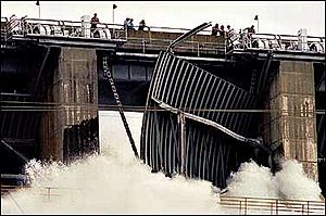
On July 17, 1995, a spillway gate at Folsom Dam had a problem. The power plant was shut down, and Gate 3 was opened to let water flow into the American River. As the gate opened, a part called a diagonal brace broke. This caused nearly 40 percent of Folsom Lake's water to be released without control. A large flood of 40,000 cubic feet per second (1,133 m³/s) rushed down the American River.
This unusual rush of freshwater into San Francisco Bay in summer confused fish like Pacific salmon and striped bass. They thought the fall rains had started and began their yearly migration months early.
After a year of looking into it, the Bureau of Reclamation said the problem was a design flaw. The Corps of Engineers, who designed the dam, didn't think about friction in a certain part of the gate. However, this was one of five identical gates that had worked fine for almost 40 years. This suggested that something changed over time. There was a slow increase in friction where the gate parts met.
Normally, maintenance should increase as a gate gets older. But the Bureau of Reclamation actually did less maintenance and lubrication because of budget cuts. Also, the lubricant they used was different from the original design. It was a new, "environmentally friendly" lubricant that wasn't waterproof enough. This allowed water to get in, causing rust and more friction.
Luckily, no one was hurt in this incident. It led to an important change in the dam industry. There was a new focus on checking and maintaining these types of gates. Many gates were updated to make them stronger and ensure they were properly lubricated.
Safety at Folsom Dam
Security Measures
After the terrorist attacks in 2001, the Bureau of Reclamation looked at dams to see if they were safe from possible threats. Folsom Dam was a big concern because 500,000 people live nearby. Because of this, the road over Folsom Dam was closed.
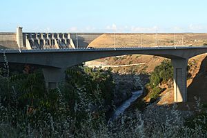
This road was a main route for the city of Folsom. Its closure caused a lot of traffic jams. Residents and city officials asked the government to reopen the road. But security concerns kept it closed. A new bridge, called Folsom Lake Crossing, was built instead. It opened on March 28, 2009.
Flood Protection
In December 1964, during a very bad storm, the water flowing into Folsom Lake was extremely high. The dam released 115,000 cubic feet (3,256 m³) of water per second.
In February 1986, almost 500,000 people were at risk of flooding. Engineers at Folsom Dam had to open the spillway gates after heavy rains. The flooding got worse because a temporary dam upstream, the Auburn Dam cofferdam, failed. This released an extra 100,000 acre-feet (0.12 km³) of water into the American River.
A huge amount of water, 250,000 cubic feet per second (7,079 m³/s), flowed into Folsom Lake. This forced dam operators to open all the spillway gates. They released 130,000 cubic feet per second (3,681 m³/s) into the American River. This was more than the downstream levees could safely handle.
Even though the dam and the Sacramento levee system held, changes were made. The amount of space kept empty for flood control in winter was increased by 50%. This was to protect against future floods. Also, about 33,000 acre-feet (0.04 km³) of sediment from the mountains settled in Folsom Lake. This reduced its capacity to store water for summer use. Folsom Dam may have prevented as much as $4.7 billion in damages in 1986 alone.
The New Year's Day storm of 1997 was the worst in recent history. Over five days, 1 million acre-feet (1.2 km³) of water flowed in. This is equal to the entire capacity of Folsom Lake. However, this time the Bureau of Reclamation was able to limit releases to less than 110,000 cubic feet per second (3,115 m³/s).
The 1997 storm was a "rain on snow" event. A warm tropical storm melted existing snow, which doubled the amount of water flowing into the lake. Before this storm, December 1996 had also been one of the wettest winters ever. The ground was already soaked, and there was a lot of snow.
The Bureau of Reclamation's Safety of Dams Program found that Sacramento was one of the most at-risk communities in the U.S. for flooding.
Two projects are currently underway to improve flood protection. One project will raise the surrounding dikes by 7 feet (2.1 m). The second is a new spillway. This spillway is designed to handle large storms and floods from melting snow. Its gates are 50 feet (15 m) lower than the old spillway. This allows for faster release of water before floods happen.
 | Claudette Colvin |
 | Myrlie Evers-Williams |
 | Alberta Odell Jones |


