
North Toowoomba, Queensland facts for kids
Quick facts for kids North ToowoombaToowoomba, Queensland |
|||||||||||||||
|---|---|---|---|---|---|---|---|---|---|---|---|---|---|---|---|

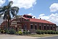
The Downs Co-operative Dairy Association Limited Factory, 2014
|
|||||||||||||||

North Toowoomba
Location in Queensland
|
|||||||||||||||
| Population | 3,332 (2021 census) | ||||||||||||||
| • Density | 1,670/km2 (4,300/sq mi) | ||||||||||||||
| Postcode(s) | 4350 | ||||||||||||||
| Area | 2.0 km2 (0.8 sq mi) | ||||||||||||||
| Time zone | AEST (UTC+10:00) | ||||||||||||||
| Location |
|
||||||||||||||
| LGA(s) | Toowoomba Region | ||||||||||||||
| State electorate(s) | Toowoomba North | ||||||||||||||
| Federal Division(s) | Groom | ||||||||||||||
|
|||||||||||||||
North Toowoomba is a suburb located in the city of Toowoomba, Queensland, Australia. It's part of the wider Toowoomba Region. In 2021, about 3,332 people lived here.
Contents
Exploring North Toowoomba's Location
North Toowoomba is found just north of the main city area of Toowoomba.
A major road called the New England Highway runs through North Toowoomba along Ruthven Street. It comes from the north (from a place called Harlaxton) and goes south towards the city centre.
The main railway line also passes through North Toowoomba. It enters from the north (Harlaxton) and leaves to the south (Toowoomba city centre). Another railway line, the Western line, enters from the south and heads north-west. It forms the border between Rockville and Harlaxton. There are no train stations in North Toowoomba today. However, in the past, there were special railway tracks for factories, like the old dairy factory.
A Look Back: North Toowoomba's History
Early Schools in North Toowoomba
In 1869, two separate schools opened in the area: Toowoomba North Boys State School and Toowoomba North Girls and Infants State School. Later, in 1937, these two schools joined together to form Toowoomba North State School. Even though it has "North" in its name, this school is actually located in Toowoomba City, not North Toowoomba itself.
St Thomas' Anglican Church
St Thomas' Anglican Church was officially opened on 21 December 1920. The church building was moved from Ruthven Street to its new spot at 2 Allan Street. It was no longer needed at its old location. The church closed on 3 February 2008 and has since been changed into a private home.
Understanding the Population of North Toowoomba
The number of people living in North Toowoomba has changed over the years:
- In 2006, there were 3,062 people.
- In 2011, the population was 3,049 people.
- In 2016, it was 2,953 people.
- By 2021, the population had grown to 3,332 people.
Special Places: Heritage Listings
North Toowoomba has some buildings and sites that are important because of their history. These are called heritage-listed sites. One example is:
- 57 Brook Street: This is the site of the The Downs Co-operative Dairy Association Limited Factory.
Learning Opportunities: Education
There are no government schools directly within North Toowoomba. However, there are several schools nearby:
- The closest primary schools are Harlaxton State School in Harlaxton (to the north), Toowoomba East State School in East Toowoomba (to the south-east), and Toowoomba North State School in Toowoomba City (to the south).
- The nearest high school is Toowoomba State High School in Mount Lofty (to the east).
Fun and Facilities: Amenities
Martin Klein Park, also known as North Toowoomba Park, is a great place to visit. You can find it at 130-136 Jellicoe Road. The park has a cricket oval where you can play sports, a playground for kids, and picnic areas where families can enjoy a meal outdoors.
Images for kids
-
The Downs Co-operative Dairy Association Limited Factory, 2014
