Oilton, Oklahoma facts for kids
Quick facts for kids
Oilton, Oklahoma
|
|
|---|---|

Location within Creek County, and the state of Oklahoma
|
|
| Country | United States |
| State | Oklahoma |
| County | Creek |
| Area | |
| • Total | 1.13 sq mi (2.93 km2) |
| • Land | 1.13 sq mi (2.93 km2) |
| • Water | 0.00 sq mi (0.00 km2) |
| Elevation | 794 ft (242 m) |
| Population
(2020)
|
|
| • Total | 885 |
| • Density | 783.19/sq mi (302.32/km2) |
| Time zone | UTC-6 (Central (CST)) |
| • Summer (DST) | UTC-5 (CDT) |
| ZIP code |
74052
|
| Area code(s) | 539/918 |
| FIPS code | 40-54000 |
| GNIS feature ID | 2411307 |
Oilton is a city located in Creek County, Oklahoma, in the United States. In 2020, about 885 people lived there. This number was a bit lower than the 1,013 people who lived there in 2010.
History of Oilton
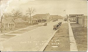
Oilton started to grow when the Cushing-Drumright Oil Field was being developed. The very first land lots were sold in early 1915 by Walter Eaton and Ed Dunn. A post office was set up on May 5, 1915.
In the same year, the First State Bank opened its doors. A local newspaper called the Oilton Gusher also began publishing. Railways soon connected Oilton to nearby towns like Jennings, Cushing, and Drumright.
By 1920, Oilton's population reached its highest point with 2,231 people. It officially became a city on April 18, 1921. Even though oil production slowed down in the 1920s and 1930s, Oilton managed to keep going. Many other oil boom towns did not survive.
Geography of Oilton
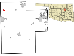
Oilton is found in the northwestern part of Creek County. It sits on the south side of the Cimarron River. This area is also close to where Keystone Lake begins to spread out.
Oklahoma State Highway 99 runs through Oilton. This highway goes north about 7 miles (11 km) to Jennings. It also goes south about 7 miles (11 km) to Drumright. The city of Tulsa is about 38 miles (61 km) to the east. Stillwater is about 30 miles (48 km) to the west.
The United States Census Bureau says that Oilton covers a total area of about 1.13 square miles (2.93 km2). All of this area is land.
Population Changes
| Historical population | |||
|---|---|---|---|
| Census | Pop. | %± | |
| 1920 | 2,231 | — | |
| 1930 | 1,518 | −32.0% | |
| 1940 | 1,225 | −19.3% | |
| 1950 | 1,109 | −9.5% | |
| 1960 | 1,100 | −0.8% | |
| 1970 | 1,087 | −1.2% | |
| 1980 | 1,244 | 14.4% | |
| 1990 | 1,060 | −14.8% | |
| 2000 | 1,099 | 3.7% | |
| 2010 | 1,013 | −7.8% | |
| 2020 | 885 | −12.6% | |
| U.S. Decennial Census | |||
In 2000, there were 1,099 people living in Oilton. These people lived in 447 households. About 291 of these households were families. The population density was about 1,690 people per square mile (653 per km2).
The average household in Oilton had about 2.46 people. The average family had about 3.11 people. In 2000, about 29.1% of the people were under 18 years old. About 15.0% were 65 years old or older. The average age of people in Oilton was 34 years.
Oilton's Economy
Oil production in Oilton has slowly gone down over time. Today, the local economy mostly depends on farming.
Most people who live in Oilton and have jobs travel to work. About 91% of employed residents commute to jobs in other towns. These towns include Bristow, Sapulpa, and Sand Springs.
See also
 In Spanish: Oilton (Oklahoma) para niños


