Okmulgee County, Oklahoma facts for kids
Quick facts for kids
Okmulgee County
|
|
|---|---|

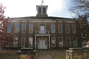
Muscogee (Creek) Council House in downtown Okmulgee.
|
|

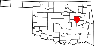
Location within the U.S. state of Oklahoma
|
|
 Oklahoma's location within the U.S. |
|
| Country | |
| State | |
| Founded | 1907 |
| Seat | Okmulgee |
| Largest city | Okmulgee |
| Area | |
| • Total | 702 sq mi (1,820 km2) |
| • Land | 697 sq mi (1,810 km2) |
| • Water | 5.0 sq mi (13 km2) 0.7%% |
| Population
(2020)
|
|
| • Total | 36,706 |
| • Density | 52.29/sq mi (20.188/km2) |
| Congressional district | 2nd |
Okmulgee County is a county in the U.S. state of Oklahoma. As of the 2020 census, about 36,706 people live here. The main city and county seat is Okmulgee.
This county is part of the Muscogee Nation Reservation. It was created in 1907 when Oklahoma became a state. The name Okmulgee comes from the Hitchita (Lower Creek) word okimulgi, which means "boiling waters." Okmulgee County is also part of the larger Tulsa metropolitan area.
Contents
History of Okmulgee County
The Creek Nation's Journey
The Creek Nation was forced to move to this area, then called Indian Territory, during the Trail of Tears. This happened after they signed treaties in 1826 and 1832, giving up their lands in Georgia and Alabama. The difficult move took place between 1827 and 1836.
Okmulgee as Capital
The Creek Nation government, led by Chief Samuel Checote, updated its rules in 1867. They chose Okmulgee as their capital city in 1868. A U.S. Post Office opened in Okmulgee on April 29, 1869. The Creek Nation built their first capitol building, made of logs, in 1869. This building was later rebuilt with stone in 1878.
County Formation and Growth
Okmulgee County was officially formed on July 16, 1907, from land that belonged to the Muskogee. At that time, about 14,362 people lived there. The county government offices were in the Creek Council House until 1916. That's when the current Okmulgee County Courthouse was built. The old council building was then used for other purposes. The county's population grew from 21,115 in 1910 to a high of 56,558 by 1930.
Railroads Arrive
Railroads came to the area starting in 1900. The St. Louis, Oklahoma and Southern Railway built a line through Okmulgee. Another line from Muskogee to Okmulgee was built in 1902–03. Other railways also served the county, helping people and goods move around.
Boundary Changes
In 1918, the border between Okmulgee County and McIntosh County was changed. This moved the towns of Grayson and Hoffman into Okmulgee County.
The Creek Council House Today
The Creek Council House is still standing today. The City of Okmulgee sold the building back to the Muscogee (Creek) Nation in 2010. Now, it is the Creek Council House Museum. It shows artifacts and exhibits about the history of the Muscogee tribe and other Native American cultures.
Geography
Okmulgee County covers a total area of about 702 square miles. Most of this (697 square miles) is land, and about 5.0 square miles (0.7%) is water.
Lakes and Rivers
Several lakes are found in the county, including Lake Henryetta, Okmulgee Lake, and Nichols Lake. Most of Dripping Springs Lake and a small part of Oklahoma's largest lake, Lake Eufaula, are also here. The Deep Fork of the North Canadian River is the main waterway in the county.
Natural Areas
The eastern part of the county has lowlands, while the western part has plains. Okmulgee Park and Dripping Springs Park are located west and southwest of the city of Okmulgee. The Deep Fork National Wildlife Refuge is in the southern part of the county. The High Spring Mountains are in the eastern part, extending south into McIntosh County.
Adjacent counties
- Tulsa County (north)
- Wagoner County (northeast)
- Muskogee County (east)
- McIntosh County (southeast)
- Okfuskee County (southwest)
- Creek County (northwest)
Population Information
| Historical population | |||
|---|---|---|---|
| Census | Pop. | %± | |
| 1910 | 21,115 | — | |
| 1920 | 55,072 | 160.8% | |
| 1930 | 56,558 | 2.7% | |
| 1940 | 50,101 | −11.4% | |
| 1950 | 44,561 | −11.1% | |
| 1960 | 36,945 | −17.1% | |
| 1970 | 35,358 | −4.3% | |
| 1980 | 39,169 | 10.8% | |
| 1990 | 36,490 | −6.8% | |
| 2000 | 39,685 | 8.8% | |
| 2010 | 40,069 | 1.0% | |
| 2020 | 36,706 | −8.4% | |
| U.S. Decennial Census 1790-1960 1900-1990 1990-2000 2010 |
|||
As of the census in 2000, there were 39,685 people living in Okmulgee County. The population density was about 22 people per square mile. In 2020, the population decreased to 36,706.
The county's population is diverse. In 2000, about 69.73% of residents were White, 10.20% Black or African American, and 12.85% Native American. About 1.95% of the population was Hispanic or Latino.
There were about 15,300 households in 2000. About 32% of these households had children under 18 living with them. The average household had about 2.53 people.
Communities
Historic Places (NRHP Sites)
Many places in Okmulgee County are listed on the National Register of Historic Places. This means they are important historical sites. Here are some of them:
- Creek National Capitol, Okmulgee
- Eastside Baptist Church, Okmulgee
- First Baptist Central Church, Okmulgee
- Harmon Athletic Field, Okmulgee
- Hugh Henry House, Henryetta
- Isparhecher House and Grave, Beggs
- Lake Okmulgee Dam Spillway Cascade, Okmulgee
- Nuyaka Mission, Okmulgee
- Okmulgee Armory, Okmulgee
- Okmulgee Black Hospital, Okmulgee
- Okmulgee County Courthouse, Okmulgee
- Okmulgee Downtown Historic District
- Okmulgee Public Library, Okmulgee
- Okmulgee Stock Pavilion, Okmulgee
- Severs Block, Okmulgee
- St. Anthony's Catholic Church, Okmulgee
- Wilson School, Henryetta
See also
 In Spanish: Condado de Okmulgee para niños
 | Percy Lavon Julian |
 | Katherine Johnson |
 | George Washington Carver |
 | Annie Easley |

