Orangevale, California facts for kids
Quick facts for kids
Orangevale
|
|
|---|---|
 |
|
| Country | |
| State | |
| County | Sacramento |
| Area | |
| • Total | 11.646 sq mi (30.16 km2) |
| • Land | 11.515 sq mi (29.82 km2) |
| • Water | 0.131 sq mi (0.34 km2) 1.13% |
| Elevation | 240 ft (73 m) |
| Population
(2020)
|
|
| • Total | 35,569 |
| • Density | 3,054.18/sq mi (1,179.23/km2) |
| Time zone | UTC-8 (PST) |
| • Summer (DST) | UTC-7 (PDT) |
| ZIP code |
95662
|
| Area code(s) | 916, 279 |
| FIPS code | 06-54092 |
| GNIS feature ID | 1656200 |
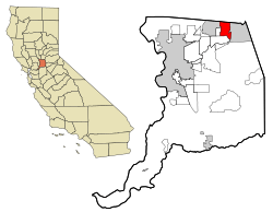
Orangevale is a community in Sacramento County, California, United States. It's a special kind of place called a census-designated place (CDP). This means it's a community that the government counts for population, but it's not officially a city.
Orangevale is part of the larger Sacramento region. In 2020, about 35,569 people lived there. It is located about 25 miles (40 km) northeast of Sacramento.
This community is known for its gently rolling hills. These hills offer great views of the Sierra Nevada mountains. Even though it's near a big city, Orangevale still feels like a rural area. Some homes in Orangevale are even set up for horses or have fruit orchards.
Contents
Where is Orangevale?
Orangevale is located at 38°40′55″N 121°12′50″W / 38.68194°N 121.21389°W. It covers a total area of about 11.6 square miles (30.0 square kilometers). Most of this area is land, with only a small part being water.
The area is mostly made up of rolling hills. These hills are close to the bottom of the Sierra Nevada mountains.
A Look at Orangevale's History
Orangevale started as a community called Orange Vale Colony. This area was once part of a large land grant from Mexico in 1844 called Rancho San Juan.
In the past, Orangevale was a very rural place. It had many orange groves, which is how it got its name. There were also olive orchards, and you can still find some of the original olive trees along streets like Chestnut, Orangevale, Main, and Walnut Avenues. Large oak trees were also common, and you can still see some in Orangevale Park today. Long before, Maidu Native Americans made trails through this area.
Who Lives in Orangevale?
In 2010, Orangevale had a population of 33,960 people. The community is home to people from many different backgrounds.
Most people in Orangevale live in family homes. In 2010, there were over 12,800 households. Many of these households (about 33%) had children under 18 living there. The average household had about 2.6 people.
The ages of people in Orangevale vary. About 23% of the population was under 18 years old. Around 13% of the people were 65 years old or older. The average age in Orangevale was about 40.7 years.
Most homes in Orangevale are owned by the people who live in them. About 73.5% of homes were owner-occupied in 2010.
Schools in Orangevale
Public schools in Orangevale are managed by the San Juan Unified School District.
Orangevale has several elementary schools, including:
- Trajan Fundamental Elementary
- Green Oaks Fundamental Elementary
- Oakview Elementary
- Pershing Elementary
- Twin Lakes Elementary
- Ottomon Elementary
For middle school, students attend Louis Pasteur Junior High or Andrew Carnegie Junior High.
The main high school for the area is Casa Roble Fundamental High School. Some students who live in the southern part of Orangevale might go to Bella Vista High School in nearby Fair Oaks.
Getting Around Orangevale
You can reach Orangevale from major highways:
- Interstate 80: Take the Greenback Lane exit (Exit 98) or the Sierra College Boulevard exit (Exit 109).
- U.S. Route 50: Take the Hazel Avenue exit (Exit 21).
Public transportation in Orangevale is provided by the Sacramento Regional Transit.
- There is a local bus route (Route 24) that runs Monday to Friday from Sunrise Mall in Citrus Heights.
- An express bus (Route 109) also runs Monday to Friday, going directly to Downtown Sacramento. These buses are usually busiest during morning and afternoon commute times.
- The closest light rail stations are the Historic Folsom station and Hazel station.
You can also take Folsom Stage Lines from the Historic Folsom light rail station to a bus stop that connects with Sacramento Regional Transit's Route 24.
Famous People from Orangevale
Some well-known people have lived in Orangevale:
- Ryan Cordell: A baseball player.
- Devin Dawson: A singer.
- Steve Lamson: A former professional motocross racer who won national championships.
- Jim McClarin: A politician.
- Eric Stuteville: A basketball player.
- Mary Whipple: A coxswain for the U.S. women's rowing team. She won gold and silver medals at the Olympics!
Nearby Communities
Orangevale is surrounded by several other communities:
 |
Placer County (Roseville) | Placer County (Roseville, Granite Bay) | Placer County (Granite Bay) |  |
| Citrus Heights | Folsom | |||
| Fair Oaks | Fair Oaks | Fair Oaks, Folsom |
See also
 In Spanish: Orangevale para niños
 | James B. Knighten |
 | Azellia White |
 | Willa Brown |

