
Oxford, Alabama facts for kids
Quick facts for kids
Oxford
|
||
|---|---|---|

Downtown Oxford
|
||
|
||
| Nickname(s):
Crossroads to the Future
|
||

Location of Oxford in Calhoun County and Talladega County, Alabama.
|
||
| Country | United States | |
| State | Alabama | |
| Counties | Calhoun, Talladega, Cleburne | |
| Area | ||
| • Total | 32.19 sq mi (83.36 km2) | |
| • Land | 31.82 sq mi (82.42 km2) | |
| • Water | 0.36 sq mi (0.94 km2) | |
| Elevation | 686 ft (209 m) | |
| Population
(2020)
|
||
| • Total | 22,069 | |
| • Density | 693.49/sq mi (267.76/km2) | |
| Time zone | UTC-6 (Central) | |
| • Summer (DST) | UTC-5 (Central) | |
| ZIP code |
36203, 36201, 36207, 36253
|
|
| Area code(s) | 256/938 | |
| FIPS code | 01-57576 | |
| GNIS feature ID | 0160330 | |

Oxford is a city in the state of Alabama, United States. It is located across three counties: Calhoun, Talladega, and Cleburne. In 2020, about 22,069 people lived there. Oxford is the biggest city in Calhoun County by population. It is also one of the main cities in the Anniston-Oxford Metropolitan Area.
Contents
History of Oxford
Oxford was founded in the early 1850s. It was the first city in Calhoun County to become an official town in 1852. The city got its name "Oxford" because there was a narrow spot in Chocolocco Creek. Farmers could easily ford (cross) their cattle from one side of the creek to the other.
Since 1970, Oxford has grown a lot. It has added large areas of land to its south and west. This includes places like Coldwater and Bynum. Originally, Oxford was only in Calhoun County. But now, it also includes parts of Talladega County and Cleburne County.
Hobson City's Story
A smaller town called Hobson City used to be part of Oxford. This area was known as the Mooree Quarter. It is about one square mile in size. Hobson City became its own official town on August 16, 1899. It was named after a naval hero from the Spanish–American War.
Hobson City was very special. It became only the second town in the United States to have a government made up entirely of Black leaders. The first was Eatonville, Florida. At first, almost everyone living in Hobson City was Black.
Geography of Oxford
Oxford covers a total area of about 83.3 square kilometers (32.19 square miles). Most of this area, about 82.15 square kilometers (31.82 square miles), is land. The rest, about 0.9 square kilometers (0.36 square miles), is water.
Oxford is located among the rolling hills at the southern end of the Blue Ridge Mountains. Close by is Cheaha Mountain, which is the highest point in Alabama. From Cheaha Mountain, you can see amazing views of the wild nature around and the city below. A big part of Oxford's southern edge is next to the Talladega National Forest.
Waterways in Oxford
Important bodies of water in Oxford include:
- Oxford Lake
- Choccolocco Park Lake
- Lake Hillabee
- Snow Creek
- The Choccolocco Creek, which flows right through the city.
Getting Around Oxford
Oxford is mainly in the southern part of Calhoun County. It is located along Interstate 20. This major highway runs through the southern part of the city. You can get on or off I-20 at exits 179, 185, 188, and 191.
- If you drive west on I-20, you can reach Birmingham in about 62 miles (100 km).
- If you drive east on I-20, you can reach Atlanta in about 88 miles (142 km).
U.S. Route 78 also goes through Oxford. It runs parallel to I-20 and connects Oxford to Cleburne County. Alabama State Route 21 connects Oxford to the city of Talladega, which is about 21 miles (34 km) southwest.
Oxford's Climate
Oxford has a humid subtropical climate. This means it has hot, humid summers and mild winters. It gets rain throughout the year.
| Climate data for Oxford, 1991–2020 simulated normals (653 ft elevation) | |||||||||||||
|---|---|---|---|---|---|---|---|---|---|---|---|---|---|
| Month | Jan | Feb | Mar | Apr | May | Jun | Jul | Aug | Sep | Oct | Nov | Dec | Year |
| Mean daily maximum °F (°C) | 54.0 (12.2) |
58.1 (14.5) |
66.4 (19.1) |
74.3 (23.5) |
81.0 (27.2) |
87.1 (30.6) |
90.0 (32.2) |
89.4 (31.9) |
85.1 (29.5) |
75.6 (24.2) |
64.8 (18.2) |
56.7 (13.7) |
73.5 (23.1) |
| Daily mean °F (°C) | 43.2 (6.2) |
46.6 (8.1) |
54.0 (12.2) |
61.5 (16.4) |
69.4 (20.8) |
76.5 (24.7) |
79.7 (26.5) |
79.0 (26.1) |
73.9 (23.3) |
63.0 (17.2) |
52.2 (11.2) |
45.7 (7.6) |
62.1 (16.7) |
| Mean daily minimum °F (°C) | 32.2 (0.1) |
35.1 (1.7) |
41.4 (5.2) |
48.7 (9.3) |
57.9 (14.4) |
65.8 (18.8) |
69.4 (20.8) |
68.5 (20.3) |
62.6 (17.0) |
50.5 (10.3) |
39.6 (4.2) |
34.7 (1.5) |
50.5 (10.3) |
| Average precipitation inches (mm) | 5.27 (133.88) |
5.48 (139.26) |
5.50 (139.60) |
4.78 (121.33) |
4.27 (108.49) |
4.76 (120.98) |
4.61 (117.05) |
3.78 (96.00) |
3.11 (78.90) |
3.44 (87.38) |
4.45 (112.92) |
5.16 (131.15) |
54.61 (1,386.94) |
| Average dew point °F (°C) | 33.8 (1.0) |
36.3 (2.4) |
41.9 (5.5) |
49.6 (9.8) |
59.4 (15.2) |
66.9 (19.4) |
70.2 (21.2) |
69.3 (20.7) |
63.9 (17.7) |
53.4 (11.9) |
42.4 (5.8) |
37.2 (2.9) |
52.0 (11.1) |
| Source: Prism Climate Group | |||||||||||||
People of Oxford
| Historical population | |||
|---|---|---|---|
| Census | Pop. | %± | |
| 1880 | 780 | — | |
| 1890 | 1,473 | 88.8% | |
| 1900 | 1,372 | −6.9% | |
| 1910 | 1,090 | −20.6% | |
| 1920 | 1,108 | 1.7% | |
| 1930 | 1,206 | 8.8% | |
| 1940 | 1,393 | 15.5% | |
| 1950 | 1,697 | 21.8% | |
| 1960 | 3,603 | 112.3% | |
| 1970 | 4,361 | 21.0% | |
| 1980 | 8,939 | 105.0% | |
| 1990 | 9,362 | 4.7% | |
| 2000 | 14,592 | 55.9% | |
| 2010 | 21,348 | 46.3% | |
| 2020 | 22,069 | 3.4% | |
| U.S. Decennial Census 2018 Estimate |
|||
The population of Oxford has grown a lot over the years. In 2020, there were 22,069 people living in the city. The city is home to many different groups of people.
Diversity in Oxford
The table below shows the different racial and ethnic groups living in Oxford, based on the 2020 census.
| Race | Num. | Perc. |
|---|---|---|
| White (non-Hispanic) | 15,309 | 69.37% |
| Black or African American (non-Hispanic) | 3,645 | 16.52% |
| Native American | 69 | 0.31% |
| Asian | 377 | 1.71% |
| Pacific Islander | 9 | 0.04% |
| Other/Mixed | 910 | 4.12% |
| Hispanic or Latino | 1,750 | 7.93% |
In Oxford, about 25.2% of the people are under 18 years old. The average age in the city is about 37.8 years.
Economy of Oxford
Oxford's economy has grown a lot recently. This is mainly because of Interstate 20. Oxford is located right between two big cities, Atlanta and Birmingham. This makes it a great place for businesses.
The Quintard Mall is a large shopping center in Oxford. It is the only fully enclosed mall between Birmingham and Douglasville, Georgia. There are also many other shopping areas in Oxford. One of the newest is the Oxford Commons, located near exit 188 on Interstate 20.
Arts and Culture in Oxford
Oxford offers several places for arts and culture:
- Oxford Performing Arts Center: A place where you can watch live shows and performances.
- Quintard Mall: A large shopping mall that also serves as a community gathering spot.
Education in Oxford
The public schools in Oxford are managed by the Oxford City School System. The city has:
- Four elementary schools
- One middle school
- One high school
A new building for Oxford High School opened in August 2010. A new Technical Building also opened at the same time, offering special classes.
Media in Oxford
Oxford has several local media options:
- Radio Stations:
- WTBJ-FM 91.3 (Christian Radio)
- WTDR-FM 92.7 (Country music)
- WVOK-FM 97.9 (Adult Contemporary music)
- WTAZ 1580 (Oldies music)
- Television:
- WEAC-CD TV 24 (Local TV station)
- Newspapers:
- The Anniston Star (a daily newspaper)
- Oxford Independent (a weekly newspaper)
- Insight (a paper about entertainment and events in Oxford and Calhoun County, published every two months)
Transportation in Oxford
The Areawide Community Transportation System provides bus service in Oxford. Buses run on an hourly schedule. Several major highways pass through the city, making it easy to travel to and from Oxford.
 Interstate 20
 U.S. Highway 78 (Hamric Drive)
 U.S. Highway 431 (Leon Smith Parkway)
 State Route 21 (Quintard Drive)
 State Route 202
Notable People from Oxford
Many interesting people have come from Oxford, Alabama. Here are a few:
- Kwon Alexander, a professional football player for the New Orleans Saints.
- The Bridges, a folk rock band.
- K. J. Britt, a professional football player for the Tampa Bay Buccaneers.
- Rick Burgess, known from the nationally syndicated radio show Rick and Bubba.
- Tae Davis, a professional football player for the Cleveland Browns.
- Trae Elston, a professional football player for the Miami Dolphins.
- Chris Hammond, a former professional baseball pitcher.
- Terry Henley, a former professional football running back.
- Vic Henley, a professional comedian.
- Maud McLure Kelly, the first woman lawyer in Alabama.
- Lash LeRoux, a cartoonist and former professional wrestler.
- Bobby McCain, a professional football player for the Miami Dolphins.
- Felton Snow, a baseball player in the Negro leagues.
- Jackson Stephens, a professional baseball pitcher for the Atlanta Braves.
- Jim Stephens, a former professional baseball catcher.
- Roc Thomas, a professional football player for the Minnesota Vikings.
Images for kids
-
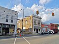
Downtown Oxford
-
Seal of Oxford, Alabama
-
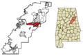
Location of Oxford in Calhoun County and Talladega County, Alabama.
See also
 In Spanish: Oxford (Alabama) para niños
