Pahute Mesa (landform) facts for kids
Quick facts for kids Pahute Mesa |
|
|---|---|

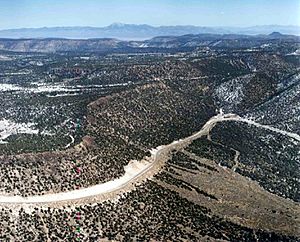
A section of Pahute Mesa (southeast, at the Test Site)
|
|
| Location | Beatty, NV, Nye, (southwest)-Great Basin region) ((north)-Mojave Desert border), Nevada, United States |
| Coordinates | 37°16′07″N 116°48′33″W / 37.268547°N 116.809234°W |
| Length | 60 mi (97 km) |
| Width | 25 mi (40 km) |
| River | Amargosa River |
The Pahute Mesa is a very large, flat-topped hill, also known as a mesa. It is about 60 miles (97 km) long and is located in southern Nye County, Nevada. A part of this mesa, in the southeast, is inside the Nevada Test Site. This area is used for special testing and is also called Pahute Mesa. It is one of the main sections of the test site.
The middle and some southeastern parts of Pahute Mesa are where the Amargosa River begins. This river flows south past Beatty and the Bare Mountains. The river then enters the Amargosa Desert and Valley just south of Beatty. It eventually flows into the southern part of Death Valley.
What is Pahute Mesa Like?
Pahute Mesa changes in width, but it is usually between 20 and 25 miles (32 to 40 km) wide. It stretches from the northwest to the southeast. On its eastern side, it joins with the Eleana Range, which is in the north-central part of the Nevada Test Site.
The mesa also forms the southwestern edge of the Nellis Air Force Range. This is a large area used by the military for training. The Nellis Range border then turns north towards Tonopah, which is about 65 mi (105 km) away.
High Points of the Mesa
The highest point on the northwest side of Pahute Mesa is Tolicha Peak, which is 7,054 feet (2,150 m) tall. Nearby, about 3 mi (5 km) to the east, is Quartz Mountain, standing at 6,945 feet (2,117 m). There are other high points in the southeast where the mesa connects with the Eleana Range.
How to Get to Pahute Mesa
U.S. Route 95 runs along the southwestern edge of Pahute Mesa. This road goes from Beatty to Goldfield, Nevada.
Since Pahute Mesa and the areas to its north are part of the Nellis Air Force Range, public access is limited. If you were to approach from the north, you would typically come from Tonopah using U.S. Route 6 in Nevada. This route goes through Gold Flat and other areas south of the Cactus Range, which marks the northwest corner of the Air Force Range.
 | Sharif Bey |
 | Hale Woodruff |
 | Richmond Barthé |
 | Purvis Young |


