
Palouse to Cascades State Park Trail facts for kids


The Palouse to Cascades State Park Trail is a super long trail in Washington State. It used to be called the John Wayne Pioneer Trail and the Iron Horse Trail. This trail follows an old railway line for about 300 miles (480 km). It stretches across two-thirds of the state, from the Cascade Mountains all the way to the Idaho border.
The land for this trail used to belong to the Chicago, Milwaukee, St. Paul & Pacific Railroad. The state of Washington took ownership of this land. Now, it's a trail for walking, biking, and horse riding. It's managed by the Washington State Parks and Recreation Commission and the Washington State Department of Natural Resources. The trail's path is "railbanked," which means it could become a railroad again someday if needed.
Contents
History of the Trail
The Palouse to Cascades Trail was once a busy railroad line. But the railroad stopped using it in 1980. After that, many people wanted to turn the old tracks into a public trail. A big supporter was Chic Hollenbeck. He started the John Wayne Pioneer Wagons and Riders Association in the 1980s.
Starting in 1981, Chic and his group organized yearly horse and wagon rides along the trail. They wanted to make sure the land stayed public. Some private landowners nearby were trying to take over parts of the land for themselves. When the trail was officially created, the eastern part was named "John Wayne Trail." This was after the group that worked hard for it. The group itself was named after the famous actor John Wayne. The western 100 miles (160 km) of the trail, from Cedar Falls to the Columbia River, was called the "Iron Horse Trail." This part became Iron Horse State Park.
In 2002, the trail got a special honor. It was named a National Recreation Trail.
In 2015, there was an attempt to close about 130 miles (209 km) of the trail. This section was east of the Columbia River. But a mistake in the wording of the plan stopped it from happening.
In April 2018, Washington State Parks suggested changing the trail's name. The old names caused some confusion. Also, the names didn't quite fit the rules for state park names. In May 2018, the Washington State Parks and Recreation Commission chose a new name: the Palouse to Cascades State Park Trail.
Cool Trail Features
Getting on the Trail (Iron Horse Park Access)
You can get onto the developed part of the trail at several spots. These spots are managed by Washington State Parks:
- Rattlesnake Lake, Cedar Falls – This is the very start of the trail on the west side. It also connects to the Snoqualmie Valley Regional Trail.
- Twin Falls
- Hyak – From here, you can get to the 2.3-mile (3.7 km) long Snoqualmie Tunnel. This tunnel goes through the top of the Cascade Mountains. In winter, this spot is great for sledding and cross-country skiing.
- Easton – As you go down the eastern side of the Cascades.
- Cle Elum – This spot gives you access to the Upper Yakima River Canyon.
- Thorp – Close to the old Thorp Mill.
- Kittitas, Washington – In the open farm valley east of Ellensburg, Washington.
- Army West – At the western edge of the trail that goes through a military training area called the Yakima Training Center.
- Army East – At the eastern edge of the trail through the Yakima Training Center, where it reaches the Columbia River.
Amazing Tunnels
The trail has six tunnels! One of them, the Snoqualmie Tunnel, is super long. It's about 11,894 feet (3,625 m) long. That's over two miles! It's one of the longest trail tunnels in the world. The other five tunnels are Boylston, Thorp, Picnic Area, Easton, and Whittier.
Wild and Undeveloped Sections

Some parts of the trail are not formally open to the public yet. These sections are managed by the Washington State Department of Natural Resources. But these parts of the trail are really cool for seeing unique natural features. They go through the Channeled Scablands. This area has amazing rock formations created by huge floods long ago. These were called the Missoula Floods. They swept across eastern Washington during the Ice Age.
At Malden, where there was once a huge railroad turntable, Washington State Parks is planning a new trailhead.
Images for kids
-
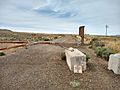
Army West Trailhead near Beverly Washington

