Kittitas, Washington facts for kids
Quick facts for kids
Kittitas, Washington
|
|
|---|---|

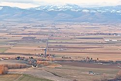
Kittitas, Washington viewed from U.S. Highway 97
|
|

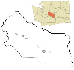
Location of Kittitas, Washington
|
|
| Country | United States |
| State | Washington |
| County | Kittitas |
| Area | |
| • Total | 0.78 sq mi (2.02 km2) |
| • Land | 0.78 sq mi (2.02 km2) |
| • Water | 0.00 sq mi (0.00 km2) |
| Elevation | 1,647 ft (502 m) |
| Population
(2020)
|
|
| • Total | 1,438 |
| • Density | 1,844/sq mi (711.9/km2) |
| Time zone | UTC-8 (Pacific (PST)) |
| • Summer (DST) | UTC-7 (PDT) |
| ZIP Code |
98934
|
| Area code(s) | 509 |
| FIPS code | 53-36045 |
| GNIS feature ID | 1506003 |
Kittitas is a city located in Kittitas County, Washington, in the United States. In 2020, about 1,438 people lived there. It's also part of the larger Ellensburg area.
Contents
What Does the Name Kittitas Mean?
The name Kittitas comes from the language of the Native American Kittitas people, called Sahaptin. There are many ideas about what the name means.
One idea is that it refers to a gravel bank in the Yakima River. Other meanings suggested include 'white chalk', 'shale rock', 'shoal people', or even 'land of beauty'. Most experts agree that all these ideas might be true, depending on the specific dialect of the language spoken.
History of Kittitas
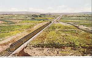
Kittitas was first settled in 1883. It officially became a city on December 9, 1931. The city grew as the Chicago, Milwaukee, St. Paul and Pacific Railroad expanded westward across the country.
The Railroad's Role
The Kittitas Yard and Depot became the main center of the community. Kittitas was one of many small farming towns that grew along the railroad lines. The railroad helped farmers and businesses sell their products in other towns and cities. This connected Kittitas to the rest of the country.
Around the small depot, a post office, stores, a church, and farm warehouses were built. The Kittitas Yard also had buildings for storage, maintenance, and a water tower. These were all needed to keep a major cross-country railroad running.
The Historic Depot
Today, the depot is the only important building left at the Kittitas Yard. It is a great example of railroad architecture from the late 1800s and early 1900s. Because of its history, it was added to the National Register of Historic Places in 1992. The Washington State Parks and Recreation Commission now owns and manages the depot.
The Milwaukee Road
The Chicago, Milwaukee, St. Paul, and Pacific Railroad, often called the Milwaukee Road, started in 1847. It first served areas from Mississippi to Wisconsin. Within 50 years, it became one of the most successful railroads in the United States.
In 1905, the Milwaukee Road decided to expand west from Chicago to Seattle. They also chose to use electricity for their trains through the western mountains. This made operations more efficient. However, the high costs of this expansion and competition from other railroads and ships using the new Panama Canal caused financial problems. In 1980, the last Milwaukee train traveled over the Cascades. After that, the system only served the Midwest.
The John Wayne Pioneer Trail
The Milwaukee Road once connected small towns in Washington. Today, it still connects these communities, but in a new way. People can now hike, bike, or ride horses along the old railroad route.
This path is called the John Wayne Pioneer Trail. It stretches over 250 miles (400 km) from Cedar Falls near North Bend to Tekoa near the Idaho border. The trail goes through tunnels, over mountains, along rivers and lakes, and through dry, sagebrush areas.
Geography and Climate
Kittitas is located in the eastern part of Kittitas County. Interstate 90 runs through the southern part of the city. You can get to Kittitas from Exit 115 on I-90. I-90 goes west about 115 miles (185 km) to Seattle and east about 166 miles (267 km) to Spokane. Ellensburg, the county seat of Kittitas County, is about 7 miles (11 km) to the west.
The city covers a total area of about 0.76 square miles (2.0 square kilometers), and all of it is land.
What is the Climate Like?
Kittitas has warm and dry summers. The average monthly temperatures do not go above 71.6°F (22°C). This type of weather is known as a warm-summer Mediterranean climate.
Population of Kittitas
| Historical population | |||
|---|---|---|---|
| Census | Pop. | %± | |
| 1920 | 200 | — | |
| 1930 | 244 | 22.0% | |
| 1940 | 501 | 105.3% | |
| 1950 | 586 | 17.0% | |
| 1960 | 536 | −8.5% | |
| 1970 | 637 | 18.8% | |
| 1980 | 782 | 22.8% | |
| 1990 | 843 | 7.8% | |
| 2000 | 1,105 | 31.1% | |
| 2010 | 1,381 | 25.0% | |
| 2020 | 1,438 | 4.1% | |
| U.S. Decennial Census | |||
Population in 2010
According to the 2010 census, there were 1,381 people living in Kittitas. These people lived in 543 households. The city had about 1,817 people per square mile (701 people per square kilometer).
Most residents were White (86.7%). A smaller number were Hispanic or Latino (13.1%). The population also included small percentages of African American, Native American, and Asian people, as well as people of two or more races.
The average age in the city was 33.3 years old. About 28.4% of the residents were under 18 years old. About 12.7% were 65 years or older. The population was almost evenly split between males (50.4%) and females (49.6%).
See also
 In Spanish: Kittitas (Washington) para niños
 | William M. Jackson |
 | Juan E. Gilbert |
 | Neil deGrasse Tyson |


