Pampas, Queensland facts for kids
Quick facts for kids PampasQueensland |
|||||||||||||||
|---|---|---|---|---|---|---|---|---|---|---|---|---|---|---|---|

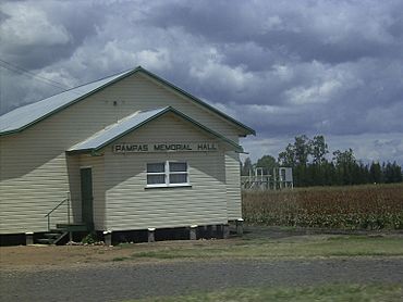
Pampas Memorial Hall, 2009
|
|||||||||||||||
| Population | 78 (2021 census) | ||||||||||||||
| • Density | 0.976/km2 (2.53/sq mi) | ||||||||||||||
| Postcode(s) | 4352 | ||||||||||||||
| Area | 79.9 km2 (30.8 sq mi) | ||||||||||||||
| Time zone | AEST (UTC+10:00) | ||||||||||||||
| Location |
|
||||||||||||||
| LGA(s) | Toowoomba Region | ||||||||||||||
| State electorate(s) | Southern Downs | ||||||||||||||
| Federal Division(s) | Maranoa | ||||||||||||||
|
|||||||||||||||
Pampas is a small, quiet area in the countryside of Queensland, Australia. It's part of the Toowoomba Region. In 2021, only 78 people lived here, making it a very small community!
Contents
About Pampas
Where is Pampas?
Pampas is located between two parts of the Condamine River, which act like natural borders. A railway line and a main road called the Gore Highway also run through Pampas. Another road, the Pampas–Horrane Road, heads north-west towards Cecil Plains.
Most of the land in Pampas is used for farming. People grow crops and practice horticulture, which is like gardening on a bigger scale.
A Look Back in Time
Pampas got its name because of the large amount of kangaroo grass that grows there. This grass is very common in the area.
There used to be a train station called Pampas railway station. It was on the Millmerran railway line, but it is no longer used today.
A school called Dry Paddock Provisional School opened in 1897. Later, in 1909, it changed its name to Pampas State School. However, the school closed its doors in 1957.
The Pampas Memorial Hall was built in late 1954. This hall is a special place for the community.
Who Lives in Pampas?
In 2016, there were 62 people living in Pampas. By 2021, the population had grown a little bit to 78 people. This shows it's a very small and close-knit community.
Local Life and Learning
There are no schools directly in Pampas. Most primary school students go to Brookstead State School in the nearby area of Brookstead. For high school, students usually travel to Millmerran State School (which goes up to Year 10) in Millmerran or Pittsworth State High School in Pittsworth.
The Pampas Memorial Hall is an important community building. You can find it at 6179 Gore Highway. It's a place where people in Pampas can gather for events and activities.
 | Misty Copeland |
 | Raven Wilkinson |
 | Debra Austin |
 | Aesha Ash |


