Paralowie, South Australia facts for kids
Quick facts for kids ParalowieSouth Australia |
|||||||||||||||
|---|---|---|---|---|---|---|---|---|---|---|---|---|---|---|---|

Houses adjacent to Port Wakefield Road
|
|||||||||||||||
| Postcode(s) | 5108 | ||||||||||||||
| Area | 18.4 km2 (7.1 sq mi) | ||||||||||||||
| LGA(s) | City of Salisbury | ||||||||||||||
| State electorate(s) | Ramsay | ||||||||||||||
| Federal Division(s) | Spence | ||||||||||||||
|
|||||||||||||||
Paralowie is a suburb located north of Adelaide, South Australia. It's about 21.4 kilometers (13.3 miles) from the city center. Most of Paralowie is made up of homes where people live.
Contents
History of Paralowie
Paralowie got its official name on November 27, 1980. The name comes from Aboriginal words: "para" means river, and "owie" means water.
People started settling here in the late 1800s. Back then, the land was mostly used for farms and "market gardens." These were places where vegetables and fruits were grown to sell.
The area didn't really grow much until after World War II. Then, from the 1980s to the mid-1990s, Paralowie grew very quickly. More homes were built, and the number of people living here increased.
Who Lives in Paralowie?
In 2021, a count of people (called a Census) showed that 17,816 people lived in Paralowie. About half were male and half were female.
Most people (65.9%) living in Paralowie were born in Australia. Other common birthplaces include England (3.8%), Vietnam (3.3%), and Afghanistan (3.2%).
The most common language spoken at home is English (64.7%). Other languages often heard include Vietnamese (4.7%) and Khmer (4.1%).
About 3% of people in Paralowie identify as Aboriginal and/or Torres Strait Islander.
The average age of people in Paralowie in 2021 was 35 years old. This is a bit younger than the average age for all Australians, which was 38.
Important Places in Paralowie
Burton Primitive Methodist Cemetery
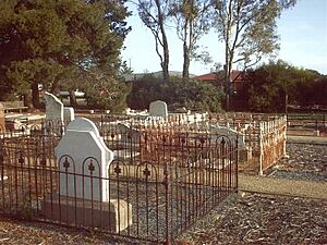
This old cemetery is on Bolivar Road in Paralowie. It's now closed, but it reminds us of the old Burton Methodist Church. That church was built in 1915 and closed in 1950. It was later taken down, and now there's a memorial stone there.
The first person buried here was George Diment in 1866. Burials continued until 1971. People have tried to fix the old headstones because this cemetery is an important historical site.
Settler's Court Farmhouse
The old farmhouse at 8 Settler's Court in Paralowie is a special historical place. It's listed on the South Australian Heritage Register. The Burdett family lived here and raised cattle. They also helped shape local events.
This farmhouse is an important example of the large farms that were common in the area before many houses were built after World War II.
Paralowie House and Grounds
This beautiful house at 94 Waterloo Corner Road was built in 1894. It's also listed as a special historical place. It shows what the area was like before it became part of the city of Adelaide. Back then, it was more like the countryside with big estates.
The house is a great example of popular architecture from the late 1800s and is still in excellent condition. Today, the house is used for a program that helps young people who don't have a stable home.
Paralowie R-12 School
Located on Whites Road, Paralowie R-12 School is a large school. It has about 1488 students, from the youngest kids in Reception all the way up to Year 12.
 | DeHart Hubbard |
 | Wilma Rudolph |
 | Jesse Owens |
 | Jackie Joyner-Kersee |
 | Major Taylor |


